 |
|
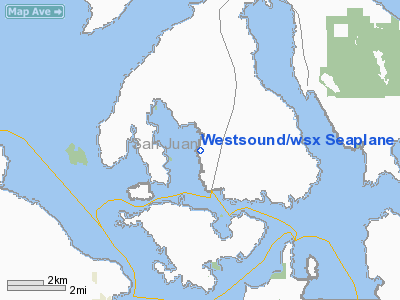
Westsound/wsx Seaplane Base Airport |
Location & QuickFacts
| FAA Information Effective: | 2008-09-25 |
| Airport Identifier: | WA83 |
| Airport Status: | Operational |
| Longitude/Latitude: | 122-57-09.6560W/48-37-04.3680N
-122.952682/48.617880 (Estimated) |
| Elevation: | 0 ft / 0.00 m (Estimated) |
| Land: | 0 acres |
| From nearest city: | 0 nautical miles N of Westsound, WA |
| Location: | San Juan County, WA |
| Magnetic Variation: | 20E (1990) |
Owner & Manager
| Ownership: | Privately owned |
| Owner: | Westsound Marina |
| Address: | Po Box 19
Orcas Island, WA 98280 |
| Phone number: | 206-376-2314 |
| Address: |
|
Airport Operations and Facilities
| Airport Use: | Private |
| Segmented Circle: | No |
| Control Tower: | No |
| Landing fee charge: | Yes |
| Sectional chart: | Seattle |
| Region: | ANM - Northwest Mountain |
| Boundary ARTCC: | ZSE - Seattle |
| Tie-in FSS: | SEA - Seattle |
| FSS on Airport: | No |
| FSS Toll Free: | 1-800-WX-BRIEF |
Runway Information
Runway 10/28
| Dimension: | 4000 x 500 ft / 1219.2 x 152.4 m |
| Surface: | WATER, |
| |
Runway 10 |
Runway 28 |
| Traffic Pattern: | Right | Left |
|
Runway 18/36
| Dimension: | 5000 x 500 ft / 1524.0 x 152.4 m |
| Surface: | WATER, |
| |
Runway 18 |
Runway 36 |
| Traffic Pattern: | Left | Left |
|
Radio Navigation Aids
| ID |
Type |
Name |
Ch |
Freq |
Var |
Dist |
| FHR | NDB | Friday Harbor | | 284.00 | 20E | 6.2 nm |
| OPZ | NDB | Lopez Island | | 356.00 | 21E | 8.4 nm |
| YJ | NDB | Victoria | | 200.00 | 21E | 17.8 nm |
| AP | NDB | Active Pass | | 378.00 | 21E | 20.4 nm |
| BVS | NDB | Skagit/bay View | | 240.00 | 21E | 23.1 nm |
| MB | NDB | Mill Bay | | 293.00 | 21E | 23.4 nm |
| WC | NDB | White Rock | | 332.00 | 21E | 24.7 nm |
| XX | NDB | Abbotsford | | 344.00 | 21E | 30.2 nm |
| VR | NDB | Vancouver | | 266.00 | 21E | 33.6 nm |
| V | NDB | Victor | | 368.00 | 22E | 36.1 nm |
| CL | NDB | Elwha | | 515.00 | 22E | 40.1 nm |
| LU | NDB | Cultus | | 214.00 | 22E | 43.2 nm |
| YCD | NDB | Nanaimo | | 251.00 | 21E | 47.5 nm |
| NUW | TACAN | Whidbey Island | 085X | | 21E | 19.6 nm |
| YYJ | VOR/DME | Victoria | 084X | 113.70 | 21E | 22.1 nm |
| CVV | VOR/DME | Penn Cove | 119X | 117.20 | 19E | 24.2 nm |
| PAE | VOR/DME | Paine | 043X | 110.60 | 20E | 49.9 nm |
| HUH | VORTAC | Whatcom | 077X | 113.00 | 20E | 24.6 nm |
| YVR | VORTAC | Vancouver | 44 | 115.90 | 21E | 28.7 nm |
Remarks
- NOISE SENSITIVE AREA - STAY OVER WATER; AVOID OVERFLIGHTS OF HOUSES ON SURROUNDING LAND. NO STEP TAXI EAST OF PICNIC ISLAND.
Images and information placed above are from
http://www.airport-data.com/airport/WA83/
We thank them for the data!
| General Info
|
| Country |
United States
|
| State |
WASHINGTON
|
| FAA ID |
WA83
|
| Latitude |
48-37-04.368N
|
| Longitude |
122-57-09.656W
|
| Elevation |
0 feet
|
| Near City |
WESTSOUND
|
We don't guarantee the information is fresh and accurate. The data may
be wrong or outdated.
For more up-to-date information please refer to other sources.
|
|


