 |
|
| A.J. Eisenberg Airport |
| IATA: ODW – ICAO: KOKH – FAA LID: OKH |
| Summary |
| Airport type |
Public |
| Owner |
A.J. Eisenberg Airport LLC |
| Serves |
Oak Harbor, Washington |
| Elevation AMSL |
193 ft / 59 m |
| Coordinates |
48°15′06″N 122°40′25″W / 48.25167°N 122.67361°W / 48.25167; -122.67361 |
| Website |
OakHarborAirport.com |
| Runways |
| Direction |
Length |
Surface |
| ft |
m |
| 7/25 |
3,265 |
995 |
Asphalt |
| Statistics (2009) |
| Aircraft operations |
16,224 |
| Based aircraft |
24 |
| Source: Federal Aviation Administration |
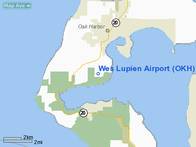
A.J. Eisenberg Airport (IATA: ODW, ICAO: KOKH, FAA LID: OKH, formerly 76S) is a public use airport located three nautical miles (6 km) southwest of the central business district of Oak Harbor, a city in Island County, Washington, United States. It is privately owned by A.J. Eisenberg Airport LLC. It was formerly known as Wes Lupien Airport and owned by Air International LLC. The airport previously had scheduled passenger service provided by Kenmore Air, which ceased operations to Oak Harbor on December 31, 2008.
Although most U.S. airports use the same three-letter location identifier for the FAA and IATA, this airport is assigned OKH by the FAA and ODW by the IATA (which assigned OKH to RAF Cottesmore in Oakham, Rutland, England).
Facilities and aircraft
The airport covers an area of 54 acres (22 ha) at an elevation of 193 feet (59 m) above mean sea level. It has one runway designated 7/25 with an asphalt surface measuring 3,265 by 25 feet (995 x 8 m).
As of July 20, 2009 A J Eisenberg Airport of Oak Harbor, WA is selling 100LL avfuel and 92 octane ethanol-free motor gas.
For the 12-month period ending May 30, 2009, the airport had 16,224 aircraft operations, an average of 44 per day: 99% general aviation and 1% air taxi. At that time there were 24 aircraft based at this airport: 87.5% single-engine and 12.5% multi-engine.
The above content comes from Wikipedia and is published under free licenses – click here to read more.
Location & QuickFacts
| FAA Information Effective: | 2008-09-25 |
| Airport Identifier: | OKH |
| Airport Status: | Operational |
| Longitude/Latitude: | 122-40-25.2000W/48-15-05.5000N
-122.673667/48.251528 (Estimated) |
| Elevation: | 193 ft / 58.83 m (Surveyed) |
| Land: | 54 acres |
| From nearest city: | 3 nautical miles SW of Oak Harbor, WA |
| Location: | Island County, WA |
| Magnetic Variation: | 19E (2000) |
Owner & Manager
| Ownership: | Privately owned |
| Owner: | Air International Llc |
| Address: | 1140 Monroe Landing Road
Oak Harbor, WA 98277 |
| Phone number: | 206-479-3333 |
| Manager: | Peter Morgan |
| Address: | 1140 Monroe Landing Road
Oak Harbor, WA 98277 |
| Phone number: | 360-929-6802 |
Airport Operations and Facilities
| Airport Use: | Open to public |
| Wind indicator: | Yes |
| Segmented Circle: | Yes |
| Control Tower: | No |
| Lighting Schedule: | DUSK-DAWN
ACTVT NSTD LIRL RY 07/25 - CTAF. PAPI RYS 07 & 25 OPER 24 HRS. |
| Beacon Color: | Clear-Green (lighted land airport) |
| Landing fee charge: | Yes
LANDING FEE FOR COMMERCIAL ACFT. |
| Sectional chart: | Seattle |
| Region: | ANM - Northwest Mountain |
| Boundary ARTCC: | ZSE - Seattle |
| Tie-in FSS: | SEA - Seattle |
| FSS on Airport: | No |
| FSS Toll Free: | 1-800-WX-BRIEF |
| NOTAMs Facility: | 76S (NOTAM-d service avaliable) |
Airport Communications
| CTAF: | 122.800 |
| Unicom: | 122.800 |
Airport Services
| Airframe Repair: | MINOR |
| Power Plant Repair: | MINOR |
| Bottled Oxygen: | NONE |
| Bulk Oxygen: | NONE |
Runway Information
Runway 07/25
| Dimension: | 3265 x 25 ft / 995.2 x 7.6 m |
| Surface: | ASPH, Poor Condition
RWY 07/25 SEVERELY CRACKED, SPALLING IN SOME AREAS. |
| Weight Limit: | Single wheel: 5000 lbs. |
| Edge Lights: | Non-standard lighting system
NSTD LIRL ONLY W 2604 FT FM RY LIGHTS. |
| |
Runway 07 |
Runway 25 |
| Longitude: | 122-40-49.3459W | 122-40-01.1066W |
| Latitude: | 48-15-05.5573N | 48-15-05.4135N |
| Elevation: | 141.00 ft | 193.00 ft |
| Alignment: | 90 | 127 |
| Traffic Pattern: | Right | Left |
| Markings: | Numbers only, Fair Condition | Numbers only, Fair Condition |
| Displaced threshold: | 507.00 ft | 0.00 ft |
| VASI: | 2-light PAPI on left side | 2-light PAPI on left side |
| Visual Glide Angle: | 4.50° | 4.50° |
| Obstruction: | 5 ft fence, 235.0 ft from runway, 7:1 slope to clear
APCH RATIO 50:1 FM DSPLCD THR.
ROAD AT 32 FT; 8 FT BRUSH & FENCE AT 65 FT. | 60 ft tree, 700.0 ft from runway, 100 ft left of centerline, 8:1 slope to clear
RWY 25 APCH RATIO 14:1 FM DSPLCD THR.
5' FENCE 29' FM THR 30L & R. |
|
Radio Navigation Aids
| ID |
Type |
Name |
Ch |
Freq |
Var |
Dist |
| BVS | NDB | Skagit/bay View | | 240.00 | 21E | 16.6 nm |
| OPZ | NDB | Lopez Island | | 356.00 | 21E | 16.9 nm |
| FHR | NDB | Friday Harbor | | 284.00 | 20E | 21.8 nm |
| YJ | NDB | Victoria | | 200.00 | 21E | 37.3 nm |
| CL | NDB | Elwha | | 515.00 | 22E | 40.4 nm |
| MB | NDB | Mill Bay | | 293.00 | 21E | 42.7 nm |
| AP | NDB | Active Pass | | 378.00 | 21E | 44.7 nm |
| WC | NDB | White Rock | | 332.00 | 21E | 45.2 nm |
| PWT | NDB | Kitsap | | 206.00 | 20E | 45.8 nm |
| XX | NDB | Abbotsford | | 344.00 | 21E | 46.5 nm |
| RNT | NDB | Renton | | 353.00 | 20E | 49.1 nm |
| NUW | TACAN | Whidbey Island | 085X | | 21E | 6.2 nm |
| CVV | VOR/DME | Penn Cove | 119X | 117.20 | 19E | 2.1 nm |
| PAE | VOR/DME | Paine | 043X | 110.60 | 20E | 25.5 nm |
| YYJ | VOR/DME | Victoria | 084X | 113.70 | 21E | 43.1 nm |
| HUH | VORTAC | Whatcom | 077X | 113.00 | 20E | 41.9 nm |
| BFI | VOT | Boeing Field | | 108.60 | | 46.0 nm |
Remarks
- TREES, BRUSH, SIGN & PARKED ACFT IN PRIM SFC.
- ULTRALIGHTS & GLIDERS PROHIBITED.
- REMAIN OUTSIDE AIRLINE SECURITY AREA IN FRONT OF TERMINAL & EAST SIDE OF FUEL STAND. SECURITY AREA MKD WITH DOUBLE YELLOW STRIPES.
Images and information placed above are from
http://www.airport-data.com/airport/OKH/
We thank them for the data!
|
|


