 |
|
Coordinates: 47°39′22″N 120°03′23″W / 47.65611°N 120.05639°W / 47.65611; -120.05639
| Waterville Airport |
| IATA: none – ICAO: none – FAA LID: 2S5 |
| Summary |
| Airport type |
Public |
| Owner |
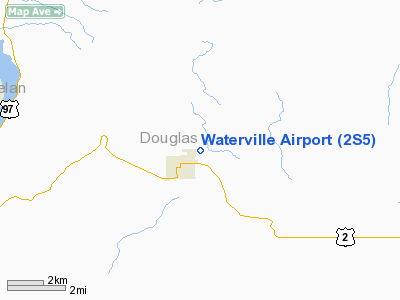
Port of Douglas County |
| Serves |
Waterville, Washington |
| Elevation AMSL |
2,645 ft / 806 m |
| Runways |
| Direction |
Length |
Surface |
| ft |
m |
| 7/25 |
2,978 |
908 |
Asphalt |
| Statistics (2005) |
| Aircraft operations |
1,000 |
| Source: Federal Aviation Administration |
Waterville Airport (FAA LID: 2S5) is a public airport located one mile (2 km) northeast of the central business district of Waterville, a town in Douglas County, Washington, United States. It is owned by the Port of Douglas County.
Facilities and aircraft
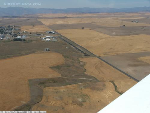
Waterville Airport covers an area of 20 acres (8 ha) which contains one runway designated 7/25 with a 2,978 x 50 ft (908 x 15 m) asphalt pavement. For the 12-month period ending December 31, 2005, the airport had 1,000 general aviation aircraft operations.
The above content comes from Wikipedia and is published under free licenses – click here to read more.
 |
(Click on the photo to enlarge) |
Location & QuickFacts
| FAA Information Effective: | 2008-09-25 |
| Airport Identifier: | 2S5 |
| Airport Status: | Operational |
| Longitude/Latitude: | 120-03-23.2660W/47-39-21.6160N
-120.056463/47.656004 (Estimated) |
| Elevation: | 2645 ft / 806.20 m (Estimated) |
| Land: | 20 acres |
| From nearest city: | 1 nautical miles NE of Waterville, WA |
| Location: | Douglas County, WA |
| Magnetic Variation: | 20E (1985) |
Owner & Manager
| Ownership: | Publicly owned |
| Owner: | Port Of Douglas County |
| Address: | 3306 5th Street Se
East Wenatchee, WA 98802 |
| Phone number: | 509-884-4700 |
| Manager: | Patrick Haley |
| Address: | 3306 5th Street Se
East Wenatchee, WA 98802 |
| Phone number: | 509-884-4700 |
Airport Operations and Facilities
| Airport Use: | Open to public |
| Wind indicator: | Yes
LIGHTED WIND TEE, UNLIGHTED WIND CONE. |
| Segmented Circle: | No |
| Control Tower: | No |
| Lighting Schedule: | DUSK-DAWN |
| Beacon Color: | Clear-Green (lighted land airport) |
| Landing fee charge: | No |
| Sectional chart: | Seattle |
| Region: | ANM - Northwest Mountain |
| Boundary ARTCC: | ZSE - Seattle |
| Tie-in FSS: | SEA - Seattle |
| FSS on Airport: | No |
| FSS Toll Free: | 1-800-WX-BRIEF |
| NOTAMs Facility: | SEA (NOTAM-d service avaliable) |
Airport Communications
Airport Services
| Fuel available: | 100LL |
| Airframe Repair: | NONE |
| Power Plant Repair: | NONE |
| Bottled Oxygen: | NONE |
| Bulk Oxygen: | NONE |
Runway Information
Runway 07/25
| Dimension: | 2978 x 50 ft / 907.7 x 15.2 m |
| Surface: | ASPH, Good Condition |
| Weight Limit: | Single wheel: 5000 lbs. |
| Edge Lights: | Medium
FIRST 272 FT OF WEST END RY 07/25 UNLGTD. |
| |
Runway 07 |
Runway 25 |
| Longitude: | 120-03-45.0190W | 120-03-01.5130W |
| Latitude: | 47-39-21.6880N | 47-39-21.5420N |
| Traffic Pattern: | Left | Left |
| Markings: | Basic, Good Condition | Basic, Good Condition |
| Displaced threshold: | 270.00 ft | 0.00 ft |
| VASI: | | 2-light PAPI on left side |
| Visual Glide Angle: | 0.00° | 3.00° |
| Obstruction: | 18 ft road, 200.0 ft from runway, 134 ft left of centerline
APPROACH SLOPE 26:1 TO DISPLCD THLD; 0:1 FM DSPLCD THLD TO ROAD @ 0 FT, 117 FT L.
+8 FT FENCE 160 FT FM THLD; 10 FT SIGN 82 FT L, 40 FT FM THLD; 8 FT POST 10 FT, 116 FT L; ACCESS ROAD 60 FT. | 21 ft pole, 1188.0 ft from runway, 171 ft right of centerline, 47:1 slope to clear
+15' HILL 125'L. |
|
Radio Navigation Aids
| ID |
Type |
Name |
Ch |
Freq |
Var |
Dist |
| EAT | FAN MARKER | Malaga | | | 21E | 18.1 nm |
| MW | NDB | Pelly | | 408.00 | 18E | 45.5 nm |
| EAT | VOR/DME | Wenatchee | 047X | 111.00 | 19E | 16.6 nm |
| MWH | VOR/DME | Moses Lake | 097X | 115.00 | 18E | 40.3 nm |
| EPH | VORTAC | Ephrata | 073X | 112.60 | 21E | 30.6 nm |
| ELN | VORTAC | Ellensburg | 126X | 117.90 | 21E | 41.3 nm |
Remarks
- HILL ON S SIDE OF RY IN TRAN SFC.
- RWY SHOULDERS SOFT IN WET WEATHER.
- ESTABD PRIOR TO 15 MAY 1959.
Images and information placed above are from
http://www.airport-data.com/airport/2S5/
We thank them for the data!
| General Info
|
| Country |
United States
|
| State |
WASHINGTON
|
| FAA ID |
2S5
|
| Latitude |
47-39-14.475N
|
| Longitude |
120-03-19.242W
|
| Elevation |
2640 feet
|
| Near City |
WATERVILLE
|
We don't guarantee the information is fresh and accurate. The data may
be wrong or outdated.
For more up-to-date information please refer to other sources.
|
|


