 |
|
| Tri-Cities Airport |
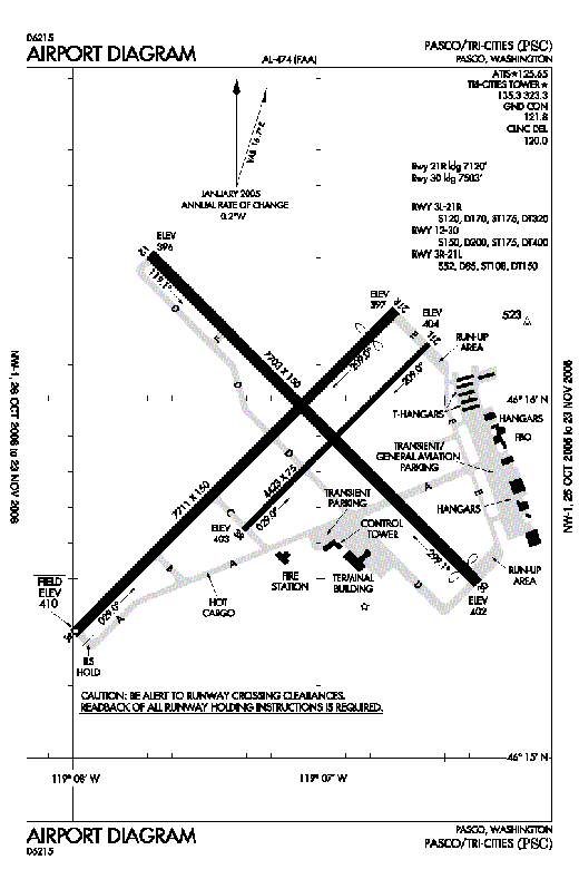 |
| FAA Airport Diagram of KPSC |
| IATA: PSC – ICAO: KPSC |
| Summary |
| Airport type |
Public |
| Operator |
Port of Pasco, Washington |
| Location |
Tri-Cities, Washington |
| Elevation AMSL |
407 ft / 124.1 m |
| Coordinates |
46°15′52.84″N 119°07′08.5″W / 46.2646778°N 119.119028°W / 46.2646778; -119.119028Coordinates: 46°15′52.84″N 119°07′08.5″W / 46.2646778°N 119.119028°W / 46.2646778; -119.119028 |
| Runways |
| Direction |
Length |
Surface |
| ft |
m |
| 12/30 |
7,700 |
2,347 |
Asphalt |
| 3L/21R |
7,700 |
2,347 |
Asphalt |
| 3R/21L |
4,425 |
1,349 |
Asphalt |
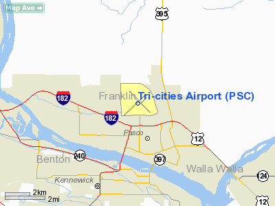
Tri-Cities Airport (IATA: PSC, ICAO: KPSC) is a public airport located 2 miles (3 km) northwest of Pasco, in Franklin County, Washington, USA. It is the third largest commercial airport in the State of Washington, and has three runways. History
The Tri-Cities Airport (then the Pasco Airport) was site of the first air mail contract flight between Elko, Nevada and Pasco, Washington made by Varney Airlines, (later United Airlines) in 1926. The airport was relocated to its present site and became known as the Franklin County Airport. The United States Navy built a naval air training station in the early 1940’s and ownership transferred to the City of Pasco when the Navy left after the war. During the first part of the war, the field was used to train beginning pilots for combat training. During the last half of the war, the mission shifted to training established pilots returning from battle in the use of newer aircraft. After the war, the Navy sold the field to the city of Pasco, but still retains training privileges. Several Navy aircraft, especially the P-3 Orion, use the field for landing and take-off training. The Port of Pasco then took ownership in 1963 and opened doors to a new Terminal Building in 1966.
In 1955, the old administration building became the home of the newly-established Columbia Basin College, which it remained until the current facility near Interstate 182 was constructed in 1966. The building later was leased to the Pasco School District #1, for use as Pasco Alternative High School (now New Horizons High School) until it was destroyed by fire in the mid 1980's. The new school is now sited near Columbia Basin College.
A substantial expansion and remodel project took place in 1986 that included access roads, parking lots, aircraft parking apron and more than doubling the size of the terminal building.
In 2003, the airport underwent another expansion and remodel that added an additional 3,000 square feet (280 m) to the ticket lobby and boarding area.
Current use
The airport's terminal at the south end of the field is currently the property of the Port of Pasco, and is the northern terminus of North 20th Avenue. Firefighting services, however, is handled by the City of Pasco. A new fire station has recently been built on the terminal grounds. The old Navy station buildings on the north end of the airport are currently being used by other firms, most notably Bergstrom Aircraft, which specializes in general aviation flight lessons.
The airport is currently undergoing a major resurfacing of the runways, which is funded by the American Recovery and Reinvestment Act.
Airlines and destinations
| Airlines |
Destinations |
| Allegiant Air |
Las Vegas, Los Angeles, Phoenix-Mesa |
| Delta Connection operated by Mesaba Airlines |
Minneapolis/St. Paul, Salt Lake City |
| Delta Connection operated by SkyWest Airlines |
Salt Lake City |
| Horizon Air |
Seattle/Tacoma |
| United Express operated by SkyWest Airlines |
Denver, San Francisco |
The above content comes from Wikipedia and is published under free licenses – click here to read more.
Location & QuickFacts
| FAA Information Effective: | 2008-09-25 |
| Airport Identifier: | PSC |
| Airport Status: | Operational |
| Longitude/Latitude: | 119-07-08.5000W/46-15-52.9000N
-119.119028/46.264694 (Estimated) |
| Elevation: | 410 ft / 124.97 m (Surveyed) |
| Land: | 2235 acres |
| From nearest city: | 2 nautical miles NW of Pasco, WA |
| Location: | Franklin County, WA |
| Magnetic Variation: | 20E (1980) |
Owner & Manager
| Ownership: | Publicly owned |
| Owner: | Port Of Pasco |
| Address: | 3601 N 20th Ave
Pasco, WA 99301 |
| Phone number: | 509-547-6352 |
| Manager: | Jim Morasch |
| Address: | 3601 N 20th Ave
Pasco, WA 99301 |
| Phone number: | 509-547-6352 |
Airport Operations and Facilities
| Airport Use: | Open to public |
| Wind indicator: | Yes |
| Segmented Circle: | Yes |
| Control Tower: | Yes |
| Lighting Schedule: | DUSK-DAWN
WHEN ATCT CLSD HIRL RY 03L/21R AND MIRL RY 12/30 PRESET ON LOW INTST TO INCREASE INTST AND ACTVT MALSR RY 21R & ODALS RY 30 - CTAF. |
| Beacon Color: | Clear-Green (lighted land airport) |
| Landing fee charge: | No |
| Sectional chart: | Seattle |
| Region: | ANM - Northwest Mountain |
| Traffic Pattern Alt: | 1000 ft |
| Boundary ARTCC: | ZSE - Seattle |
| Tie-in FSS: | SEA - Seattle |
| FSS on Airport: | No |
| FSS Toll Free: | 1-800-WX-BRIEF |
| NOTAMs Facility: | PSC (NOTAM-d service avaliable) |
| Certification type/date: | I B S 05/1973
PPR UNSKED ACR OPNS WITH MORE THAN 30 PSGR SEATS CALL AMGR 509-547-6352. |
| Federal Agreements: | NGPY |
Airport Communications
| CTAF: | 135.300 |
| Unicom: | 122.950 |
Airport Services
| Fuel available: | 100LLA1+
AFTER HOURS FUEL CALL (509) 547-6271. CALL-OUT FEE. |
| Airframe Repair: | MAJOR |
| Power Plant Repair: | MAJOR |
| Bottled Oxygen: | NONE |
| Bulk Oxygen: | LOW |
Runway Information
Runway 03L/21R
| Dimension: | 7711 x 150 ft / 2350.3 x 45.7 m |
| Surface: | ASPH, Good Condition |
| Surface Treatment: | Saw-cut or plastic Grooved |
| Weight Limit: | Single wheel: 120000 lbs.
Dual wheel: 170000 lbs.
Dual tandem wheel: 320000 lbs. |
| Edge Lights: | High |
| |
Runway 03L |
Runway 21R |
| Longitude: | 119-08-00.5725W | 119-06-41.9914W |
| Latitude: | 46-15-21.4447N | 46-16-14.5749N |
| Elevation: | 410.00 ft | 401.00 ft |
| Alignment: | 45 | 127 |
| ILS Type: | | ILS
|
| Traffic Pattern: | Left | Right |
| Markings: | Non-precision instrument, Good Condition | Precision instrument, Good Condition |
| Crossing Height: | 50.00 ft | 54.00 ft |
| Displaced threshold: | 0.00 ft | 600.00 ft |
| VASI: | 4-light PAPI on left side | 4-light PAPI on left side |
| Visual Glide Angle: | 3.00° | 3.00° |
| RVR Equipment: | | touchdown |
| Approach lights: | | MALSR |
| Runway End Identifier: | Yes | |
| Obstruction: | 61 ft tree, 2550.0 ft from runway, 750 ft right of centerline, 38:1 slope to clear | 49 ft pole, 1900.0 ft from runway, 450 ft left of centerline, 34:1 slope to clear
+81' TWR 3036' & 900'L 37:1 BASED ON DSPLCD THR. |
| Decleard distances: | Take off run available 7711.00 ft
Take off distance available 7711.00 ft
Actual stop distance available 7711.00 ft
Landing distance available 7711.00 ft
| Take off run available 7711.00 ft
Take off distance available 7711.00 ft
Actual stop distance available 7711.00 ft
Landing distance available 7111.00 ft
|
|
Runway 03R/21L
| Dimension: | 4423 x 75 ft / 1348.1 x 22.9 m |
| Surface: | ASPH, Fair Condition |
| Weight Limit: | Single wheel: 52000 lbs.
Dual wheel: 85000 lbs.
Dual tandem wheel: 150000 lbs. |
| |
Runway 03R |
Runway 21L |
| Longitude: | 119-07-19.2713W | 119-06-34.1856W |
| Latitude: | 46-15-38.3544N | 46-16-08.8258N |
| Elevation: | 403.00 ft | 404.00 ft |
| Alignment: | 45 | 127 |
| Traffic Pattern: | Right | Left |
| Markings: | Basic, Good Condition | Basic, Good Condition |
| Obstruction: | , 50:1 slope to clear | 79 ft tower, 2445.0 ft from runway, 77 ft left of centerline, 28:1 slope to clear |
| Decleard distances: | Take off run available 4423.00 ft
Take off distance available 4423.00 ft
Actual stop distance available 4423.00 ft
Landing distance available 4423.00 ft
| Take off run available 4423.00 ft
Take off distance available 4423.00 ft
Actual stop distance available 4423.00 ft
Landing distance available 4423.00 ft
|
|
Runway 12/30
| Dimension: | 7703 x 150 ft / 2347.9 x 45.7 m |
| Surface: | ASPH, Good Condition |
| Surface Treatment: | Saw-cut or plastic Grooved |
| Weight Limit: | Single wheel: 150000 lbs.
Dual wheel: 200000 lbs.
Dual tandem wheel: 400000 lbs. |
| Edge Lights: | Medium |
| |
Runway 12 |
Runway 30 |
| Longitude: | 119-07-40.6838W | 119-06-24.1721W |
| Latitude: | 46-16-24.5059N | 46-15-30.0461N |
| Elevation: | 396.00 ft | 402.00 ft |
| Alignment: | 127 | 127 |
| Traffic Pattern: | Left | Left |
| Markings: | Non-precision instrument, Good Condition | Non-precision instrument, Good Condition |
| Crossing Height: | 56.00 ft | 54.00 ft |
| Displaced threshold: | 0.00 ft | 200.00 ft |
| VASI: | 4-box on left side | 4-light PAPI on left side |
| Visual Glide Angle: | 3.00° | 3.00° |
| Approach lights: | | ODALS |
| Runway End Identifier: | Yes | |
| Obstruction: | , 50:1 slope to clear | 30 ft tree, 1312.0 ft from runway, 177 ft left of centerline, 37:1 slope to clear |
| Decleard distances: | Take off run available 7703.00 ft
Take off distance available 7703.00 ft
Actual stop distance available 7503.00 ft
Landing distance available 7503.00 ft
| Take off run available 7703.00 ft
Take off distance available 7703.00 ft
Actual stop distance available 7703.00 ft
Landing distance available 7503.00 ft
|
|
Radio Navigation Aids
| ID |
Type |
Name |
Ch |
Freq |
Var |
Dist |
| PD | NDB | Foris | | 230.00 | 20E | 37.9 nm |
| PSC | VOR/DME | Pasco | 021X | 108.40 | 20E | 0.2 nm |
| ALW | VOR/DME | Walla Walla | 111X | 116.40 | 20E | 36.0 nm |
| PDT | VORTAC | Pendleton | 094X | 114.70 | 20E | 34.9 nm |
Remarks
- BIRD HAZARD; SEE SPECIAL NOTICE FOR WASHINGTON IN AIM PART 3A.
- TPA 1500' TURBINE PWRD ACFT; ALL OTRS 1000'.
- RY 03R/21L IS AVBL FOR ACR ACFT FOR TAXIING DURING DALGT AND VFR CONDITIONS ONLY.
- RY 21L & 03R NOT AVBL AS MOVEMENT AREA FOR ACR ACFT WITH MORE THAN 9 PSGR SEATS OR GREATER FOR LNDG AND TKOF.
- WATER FOWL ON & INVOF ARPT SPRING & FALL.
- ESTAB PRIOR TO 15 MAY 1959.
Images and information placed above are from
http://www.airport-data.com/airport/PSC/
We thank them for the data!
| General Info
|
| Country |
United States
|
| State |
WASHINGTON
|
| FAA ID |
PSC
|
| Latitude |
46-15-52.849N
|
| Longitude |
119-07-08.505W
|
| Elevation |
407 feet
|
| Near City |
PASCO
|
We don't guarantee the information is fresh and accurate. The data may
be wrong or outdated.
For more up-to-date information please refer to other sources.
|
|


