|
|
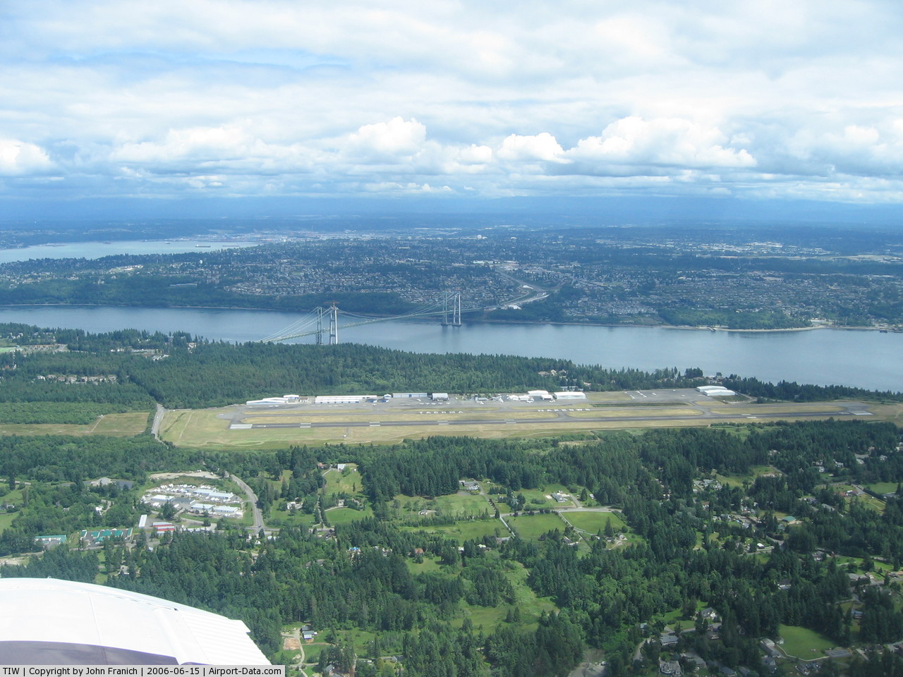
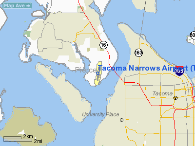
| Tacoma Narrows Airport |
 |
| IATA: TIW – ICAO: KTIW – FAA LID: TIW |
| Summary |
| Airport type |
Public |
| Operator |
City of Tacoma |
| Location |
Gig Harbor, Washington |
| Elevation AMSL |
292 ft / 89 m |
| Coordinates |
47°16′05″N 122°34′41″W / 47.26806°N 122.57806°W / 47.26806; -122.57806Coordinates: 47°16′05″N 122°34′41″W / 47.26806°N 122.57806°W / 47.26806; -122.57806 |
| Runways |
| Direction |
Length |
Surface |
| ft |
m |
| 17/35 |
5,002 |
1,525 |
Asphalt / Aggregate |
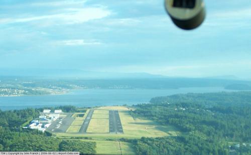
Tacoma Narrows Airport (IATA: TIW, ICAO: KTIW, FAA LID: TIW) is a public airport located four miles (6.4 km) west of Tacoma, serving Pierce County, Washington, USA. The airport is mostly used for general aviation.
Facilities
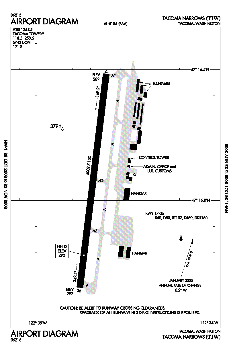
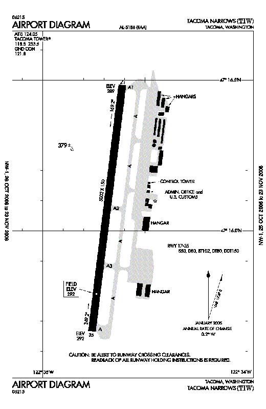
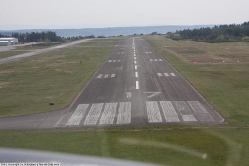
Tacoma Narrows Airport covers 644 acres (261 ha) and has one runway:
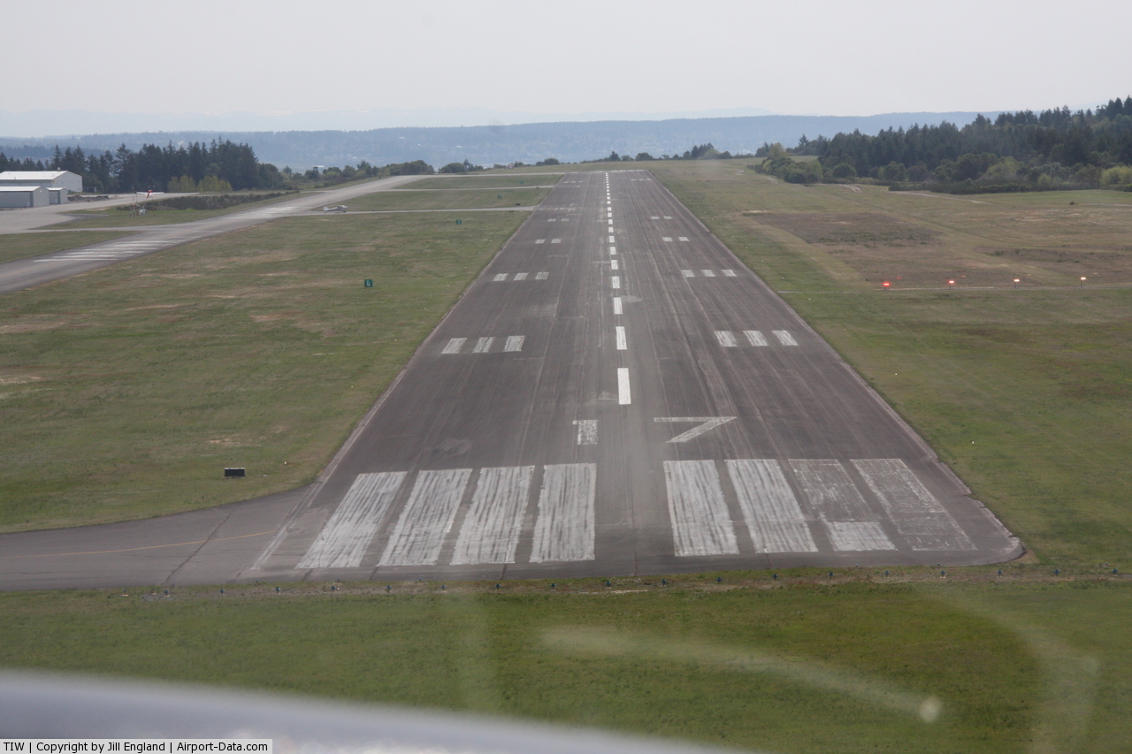
- Runway 17/35: 5,002 x 150 ft. (1,525 x 46 m), Surface: Asphalt / Aggregate
The above content comes from Wikipedia and is published under free licenses – click here to read more.
 |
(Click on the photo to enlarge) |
 |
(Click on the photo to enlarge) |
 |
(Click on the photo to enlarge) |
Location & QuickFacts
| FAA Information Effective: | 2008-09-25 |
| Airport Identifier: | TIW |
| Airport Status: | Operational |
| Longitude/Latitude: | 122-34-41.2000W/47-16-04.6000N
-122.578111/47.267944 (Estimated) |
| Elevation: | 294 ft / 89.61 m (Surveyed) |
| Land: | 644 acres |
| From nearest city: | 4 nautical miles W of Tacoma, WA |
| Location: | Pierce County, WA |
| Magnetic Variation: | 20E (1990) |
Owner & Manager
| Ownership: | Publicly owned |
| Owner: | City Of Tacoma |
| Address: | 747 Market Street, Rm 737
Tacoma, WA 98402 |
| Phone number: | 253-591-5320 |
| Manager: | Mike Slevin
FOR OPERATIONS INFORMATION CONTACT RICH MULLER, OPERATIONS MANAGER 253-853-5844. |
| Address: | 1202 26th Avenue Nw
Gig Harbor, WA 98335 |
| Phone number: | 253-853-5844 |
Airport Operations and Facilities
| Airport Use: | Open to public |
| Wind indicator: | Yes |
| Segmented Circle: | Yes |
| Control Tower: | Yes |
| Lighting Schedule: | DUSK-DAWN
ACTVT MALSR RY 17 & PAPI RY 17 - CTAF. |
| Beacon Color: | Clear-Green (lighted land airport) |
| Landing fee charge: | Yes |
| Sectional chart: | Seattle |
| Region: | ANM - Northwest Mountain |
| Traffic Pattern Alt: | 1000 ft |
| Boundary ARTCC: | ZSE - Seattle |
| Tie-in FSS: | SEA - Seattle |
| FSS on Airport: | No |
| FSS Toll Free: | 1-800-WX-BRIEF |
| NOTAMs Facility: | TIW (NOTAM-d service avaliable) |
| Federal Agreements: | NGY |
Airport Communications
| CTAF: | 118.500 |
| Unicom: | 122.950 |
Airport Services
| Fuel available: | 100LLA |
| Airframe Repair: | MAJOR |
| Power Plant Repair: | MAJOR |
| Bottled Oxygen: | LOW |
| Bulk Oxygen: | NONE |
Runway Information
Runway 17/35
| Dimension: | 5002 x 150 ft / 1524.6 x 45.7 m |
| Surface: | ASPH, Good Condition |
| Surface Treatment: | Aggregate Friction Seal Coat |
| Weight Limit: | Single wheel: 50000 lbs.
Dual wheel: 80000 lbs.
Dual tandem wheel: 80000 lbs.
Dual dual tandem wheel: 150000 lbs. |
| Edge Lights: | Medium |
| |
Runway 17 |
Runway 35 |
| Longitude: | 122-34-36.7611W | 122-34-45.6105W |
| Latitude: | 47-16-29.0830N | 47-15-40.0834N |
| Elevation: | 291.00 ft | 294.00 ft |
| Alignment: | 127 | 7 |
| ILS Type: | ILS
| |
| Traffic Pattern: | Right | Left |
| Markings: | Precision instrument, Fair Condition | Non-precision instrument, Fair Condition |
| Crossing Height: | 50.00 ft | 51.00 ft |
| VASI: | 4-light PAPI on right side | 4-box on left side |
| Visual Glide Angle: | 3.00° | 3.00° |
| Approach lights: | MALSR | |
| Runway End Identifier: | | Yes |
|
Radio Navigation Aids
| ID |
Type |
Name |
Ch |
Freq |
Var |
Dist |
| GR | NDB | Graye | | 216.00 | 18E | 7.2 nm |
| ODD | NDB | Dondo | | 224.00 | 19E | 12.4 nm |
| CAN | NDB | Carney | | 274.00 | 20E | 13.6 nm |
| PWT | NDB | Kitsap | | 206.00 | 20E | 15.3 nm |
| LAC | NDB | Lacomas | | 328.00 | 18E | 15.7 nm |
| RNT | NDB | Renton | | 353.00 | 20E | 20.1 nm |
| MNC | NDB | Mason County | | 348.00 | 19E | 20.8 nm |
| TDO | NDB | Toledo | | 219.00 | 20E | 48.6 nm |
| PAE | VOR/DME | Paine | 043X | 110.60 | 20E | 41.0 nm |
| TCM | VORTAC | Mcchord | 033X | 109.60 | 22E | 8.4 nm |
| SEA | VORTAC | Seattle | 115X | 116.80 | 19E | 14.9 nm |
| OLM | VORTAC | Olympia | 081X | 113.40 | 19E | 22.2 nm |
| SEA | VOT | Seattle-tacoma | | 117.50 | | 15.4 nm |
| BFI | VOT | Boeing Field | | 108.60 | | 19.2 nm |
Remarks
- NOISE SENSITIVE ARPT; FOR NOISE ABATEMENT & TFC PROCEDURES CALL AMGR 253-853-5844.
- DEER ON & INVOF ARPT.
Images and information placed above are from
http://www.airport-data.com/airport/TIW/
We thank them for the data!
| General Info
|
| Country |
United States
|
| State |
WASHINGTON
|
| FAA ID |
TIW
|
| Latitude |
47-16-04.552N
|
| Longitude |
122-34-41.159W
|
| Elevation |
292 feet
|
| Near City |
TACOMA
|
We don't guarantee the information is fresh and accurate. The data may
be wrong or outdated.
For more up-to-date information please refer to other sources.
|
|