 |
|
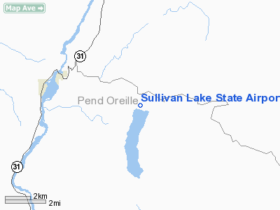
Sullivan Lake State Airport |
Location & QuickFacts
| FAA Information Effective: | 2008-09-25 |
| Airport Identifier: | 09S |
| Airport Status: | Operational |
| Longitude/Latitude: | 117-17-02.3490W/48-50-27.2230N
-117.283986/48.840895 (Estimated) |
| Elevation: | 2614 ft / 796.75 m (Estimated) |
| Land: | 20 acres |
| From nearest city: | 3 nautical miles SE of Metaline Falls, WA |
| Location: | Pend Oreille County, WA |
| Magnetic Variation: | 20E (1985) |
Owner & Manager
| Ownership: | Publicly owned |
| Owner: | Wsdot Aviation Div |
| Address: | 3704 172nd Street Ne, Suite K2, Po Box 3367
Arlington, WA 98223-6336 |
| Phone number: | 360-651-6300 |
| Manager: | Jim Scott |
| Address: | 3704 172nd Street Ne, Suite K2, Po Box 3367
Arlington, WA 98223-6336 |
| Phone number: | 800-552-0666 |
Airport Operations and Facilities
| Airport Use: | Open to public |
| Wind indicator: | Yes |
| Segmented Circle: | No |
| Control Tower: | No |
| Landing fee charge: | No |
| Sectional chart: | Seattle |
| Region: | ANM - Northwest Mountain |
| Boundary ARTCC: | ZSE - Seattle |
| Tie-in FSS: | SEA - Seattle |
| FSS on Airport: | No |
| FSS Toll Free: | 1-800-WX-BRIEF |
| NOTAMs Facility: | SEA (NOTAM-d service avaliable) |
Airport Communications
Airport Services
| Airframe Repair: | NONE |
| Power Plant Repair: | NONE |
| Bottled Oxygen: | NONE |
| Bulk Oxygen: | NONE |
Runway Information
Runway 16/34
| Dimension: | 1765 x 150 ft / 538.0 x 45.7 m |
| Surface: | TURF, Poor Condition
SFC ROUGH. |
| |
Runway 16 |
Runway 34 |
| Longitude: | 117-17-02.3490W | 117-17-02.3500W |
| Latitude: | 48-50-35.9290N | 48-50-18.5170N |
| Elevation: | 2621.00 ft | 2603.00 ft |
| Traffic Pattern: | Left | Left |
| Obstruction: | 181 ft trees, 1700.0 ft from runway, 45 ft right of centerline, 9:1 slope to clear | 10 ft road, 28.0 ft from runway, 1:1 slope to clear |
|
Radio Navigation Aids
| ID |
Type |
Name |
Ch |
Freq |
Var |
Dist |
| ION | NDB | Ione | | 379.00 | 21E | 9.4 nm |
| EF | NDB | Champion | | 206.00 | 20E | 28.5 nm |
| YK | NDB | Brilliant | | 269.00 | 20E | 32.2 nm |
| CG | NDB | Castlegar | | 227.00 | 20E | 38.2 nm |
| SZT | NDB | Sandpoe | | 264.00 | 20E | 43.8 nm |
Remarks
- ARPT CLSD YEARLY 1 OCT-1 JUN.
- PEDESTRIANS; VEHICLES & ANIMALS ON & INVOF RY.
- TREES & FENCES IN PRIMARY SFCS; TREES BOTH SIDES IN TRANSITION SFCS.
- FOR RY CONDS PRIOR TO USE CALL 360-651-6300 OR 1-800-552-0666.
- GROUND DROPS RAPIDLY BEYOND RUNWAY ENDS.
- WATCH FOR GROUND SQUIRREL HOLES IN RY.
- EXISTED PRIOR TO 1959.
Images and information placed above are from
http://www.airport-data.com/airport/09S/
We thank them for the data!
| General Info
|
| Country |
United States
|
| State |
WASHINGTON
|
| FAA ID |
09S
|
| Latitude |
48-50-29.719N
|
| Longitude |
117-17-03.869W
|
| Elevation |
2614 feet
|
| Near City |
METALINE FALLS
|
We don't guarantee the information is fresh and accurate. The data may
be wrong or outdated.
For more up-to-date information please refer to other sources.
|
|


