 |
|
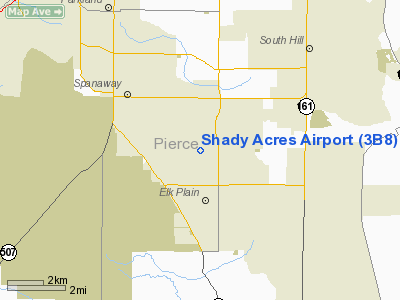
Location & QuickFacts
| FAA Information Effective: | 2008-09-25 |
| Airport Identifier: | 3B8 |
| Airport Status: | Operational |
| Longitude/Latitude: | 122-22-15.9000W/47-04-13.4000N
-122.371083/47.070389 (Estimated) |
| Elevation: | 445 ft / 135.64 m (Estimated) |
| Land: | 10 acres |
| From nearest city: | 3 nautical miles SE of Spanaway, WA |
| Location: | Pierce County, WA |
| Magnetic Variation: | 20E (1985) |
Owner & Manager
| Ownership: | Privately owned |
| Owner: | Shady Acres Apt Inc |
| Address: | 4409 208 St E
Spanaway, WA 98387 |
| Phone number: | 253-846-8953 |
| Manager: | Joseph Price |
| Address: | P. O. Box 4962
Spanaway, WA 98387 |
| Phone number: | 253-846-8953 |
Airport Operations and Facilities
| Airport Use: | Open to public |
| Wind indicator: | Yes |
| Segmented Circle: | No
LANDING PATTERN INDICATOR PAINTED ON RY. |
| Control Tower: | No |
| Lighting Schedule: | DUSK-DAWN |
| Landing fee charge: | No |
| Sectional chart: | Seattle |
| Region: | ANM - Northwest Mountain |
| Boundary ARTCC: | ZSE - Seattle |
| Tie-in FSS: | SEA - Seattle |
| FSS on Airport: | No |
| FSS Toll Free: | 1-800-WX-BRIEF |
| NOTAMs Facility: | SEA (NOTAM-d service avaliable) |
Airport Communications
Airport Services
| Airframe Repair: | NONE |
| Power Plant Repair: | NONE |
| Bottled Oxygen: | NONE |
| Bulk Oxygen: | NONE |
Runway Information
Runway 16/34
| Dimension: | 1800 x 20 ft / 548.6 x 6.1 m |
| Surface: | ASPH, Fair Condition |
| |
Runway 16 |
Runway 34 |
| Traffic Pattern: | Left | Right |
| Markings: | Nonstandard, Fair Condition
RWY 16 ID IS NOT STD DIST FROM RWY END. | Nonstandard, Fair Condition
DSPLCD THLD MKD WITH NSTD CHEVRONS. |
| Displaced threshold: | 0.00 ft | 200.00 ft |
| Obstruction: | 12 ft trees, 200.0 ft from runway
45 FT TREE 17 FT, 81 FT RT. | 15 ft road, 200.0 ft from runway, 38 ft left of centerline
APCH RATIO 0:1 FM DSPLCD THLD TO 4 FT FENCE AT 0 FT, 100 FT L; 33 FT PWR POLE AT 206 FT, 81 FT R.
ROAD AT 8 FT; RWY 34 APCH SLOPE 13:1 TO DSPLCD THR. |
|
Radio Navigation Aids
| ID |
Type |
Name |
Ch |
Freq |
Var |
Dist |
| LAC | NDB | Lacomas | | 328.00 | 18E | 8.5 nm |
| GR | NDB | Graye | | 216.00 | 18E | 10.7 nm |
| ODD | NDB | Dondo | | 224.00 | 19E | 17.8 nm |
| RNT | NDB | Renton | | 353.00 | 20E | 26.3 nm |
| CAN | NDB | Carney | | 274.00 | 20E | 28.0 nm |
| PWT | NDB | Kitsap | | 206.00 | 20E | 29.8 nm |
| MNC | NDB | Mason County | | 348.00 | 19E | 31.1 nm |
| TDO | NDB | Toledo | | 219.00 | 20E | 40.2 nm |
| TCM | VORTAC | Mcchord | 033X | 109.60 | 22E | 6.3 nm |
| SEA | VORTAC | Seattle | 115X | 116.80 | 19E | 22.1 nm |
| OLM | VORTAC | Olympia | 081X | 113.40 | 19E | 22.5 nm |
| SEA | VOT | Seattle-tacoma | | 117.50 | | 22.6 nm |
| BFI | VOT | Boeing Field | | 108.60 | | 27.6 nm |
Remarks
- ALL PATTERNS TO THE EAST.
- SHADY ACRES PAINTED ON RWY MIDFIELD.
- MILITARY ACTVTY ON & INVOF ARPT.
- PLINE EAST TREES. PWR POLE N OF FIELD TREES MRKD WITH ORANGE BALLS.
- PWR PLANTS WITH EMISSIONS THAT MAY NOT BE VSBL .5 & 1 SM NE OF APT.
- PRVDD ALL TFC PATS ARE ESTABD TO THE E FROM THE ARPT.
Images and information placed above are from
http://www.airport-data.com/airport/3B8/
We thank them for the data!
| General Info
|
| Country |
United States
|
| State |
WASHINGTON
|
| FAA ID |
3B8
|
| Latitude |
47-04-13.400N
|
| Longitude |
122-22-15.900W
|
| Elevation |
445 feet
|
| Near City |
SPANAWAY
|
We don't guarantee the information is fresh and accurate. The data may
be wrong or outdated.
For more up-to-date information please refer to other sources.
|
|


