 |
|
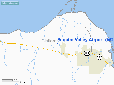
Location & QuickFacts
| FAA Information Effective: | 2008-09-25 |
| Airport Identifier: | W28 |
| Airport Status: | Operational |
| Longitude/Latitude: | 123-11-13.6440W/48-05-53.3320N
-123.187123/48.098148 (Estimated) |
| Elevation: | 144 ft / 43.89 m (Surveyed) |
| Land: | 190 acres |
| From nearest city: | 4 nautical miles NW of Sequim, WA |
| Location: | Clallam County, WA |
| Magnetic Variation: | 21E (1985) |
Owner & Manager
| Ownership: | Privately owned |
| Owner: | Winifred Sallee |
| Address: | 468 Dorothy Hunt Lane
Sequim, WA 98382 |
| Phone number: | 360-683-4444 |
| Manager: | Winifred Sallee |
| Address: | 468 Dorothy Hunt Lane
Sequim, WA 98382 |
| Phone number: | 360-683-4444 |
Airport Operations and Facilities
| Airport Use: | Open to public |
| Wind indicator: | Yes
GPS MONUMENT LOCATED AT WINDSOCK. |
| Segmented Circle: | Yes |
| Control Tower: | No |
| Lighting Schedule: | DUSK-DAWN |
| Beacon Color: | Clear-Green (lighted land airport) |
| Landing fee charge: | No |
| Sectional chart: | Seattle |
| Region: | ANM - Northwest Mountain |
| Boundary ARTCC: | ZSE - Seattle |
| Tie-in FSS: | SEA - Seattle |
| FSS on Airport: | No |
| FSS Toll Free: | 1-800-WX-BRIEF |
| NOTAMs Facility: | SEA (NOTAM-d service avaliable) |
Airport Communications
| CTAF: | 122.700 |
| Unicom: | 122.700 |
Airport Services
| Fuel available: | 100LL |
| Airframe Repair: | MINOR |
| Power Plant Repair: | MAJOR |
| Bottled Oxygen: | NONE |
| Bulk Oxygen: | NONE |
Runway Information
Runway 09L/27R
| Dimension: | 3500 x 100 ft / 1066.8 x 30.5 m |
| Surface: | TURF, Good Condition |
| |
Runway 09L |
Runway 27R |
| Traffic Pattern: | Right | Left |
| Obstruction: | 5 ft fence, 50 ft left of centerline | 41 ft trees, 610.0 ft from runway, 14:1 slope to clear |
|
Runway 09R/27L
| Dimension: | 3510 x 40 ft / 1069.8 x 12.2 m |
| Surface: | ASPH, Good Condition |
| Edge Lights: | Low |
| |
Runway 09R |
Runway 27L |
| Longitude: | 123-11-51.2380W | 123-10-51.8300W |
| Latitude: | 48-05-57.6290N | 48-05-47.4040N |
| Traffic Pattern: | Right | Left |
| Markings: | , | Nonstandard, Fair Condition
RY 27L MKD WITH BROKEN LINE. |
| Obstruction: | 90 ft trees, 1362.0 ft from runway, 12:1 slope to clear | 53 ft trees, 612.0 ft from runway, 40 ft right of centerline, 7:1 slope to clear |
|
Radio Navigation Aids
| ID |
Type |
Name |
Ch |
Freq |
Var |
Dist |
| CL | NDB | Elwha | | 515.00 | 22E | 19.6 nm |
| OPZ | NDB | Lopez Island | | 356.00 | 21E | 25.3 nm |
| FHR | NDB | Friday Harbor | | 284.00 | 20E | 26.5 nm |
| YJ | NDB | Victoria | | 200.00 | 21E | 33.9 nm |
| MB | NDB | Mill Bay | | 293.00 | 21E | 37.2 nm |
| BVS | NDB | Skagit/bay View | | 240.00 | 21E | 38.0 nm |
| PWT | NDB | Kitsap | | 206.00 | 20E | 40.4 nm |
| CAN | NDB | Carney | | 274.00 | 20E | 43.7 nm |
| AP | NDB | Active Pass | | 378.00 | 21E | 46.8 nm |
| NUW | TACAN | Whidbey Island | 085X | | 21E | 26.1 nm |
| CVV | VOR/DME | Penn Cove | 119X | 117.20 | 19E | 20.5 nm |
| PAE | VOR/DME | Paine | 043X | 110.60 | 20E | 38.1 nm |
| YYJ | VOR/DME | Victoria | 084X | 113.70 | 21E | 39.6 nm |
| BFI | VOT | Boeing Field | | 108.60 | | 49.5 nm |
Remarks
- DEER ON & INVOF ARPT.
- PAVED TAXIWAYS CROSS TURF RY 09L/27R.
- TFC PATTERN FLOWN S OF RY 08/26; INSTALL SEGMENTED CIRCLE; POST RY END SIGNS FOR DEPARTURE PATTERNS; INSTALL UNICOM; HAVE RMK ADDED TO AFD RY 08 IS RGT TFC.
Images and information placed above are from
http://www.airport-data.com/airport/W28/
We thank them for the data!
| General Info
|
| Country |
United States
|
| State |
WASHINGTON
|
| FAA ID |
W28
|
| Latitude |
48-05-53.332N
|
| Longitude |
123-11-13.644W
|
| Elevation |
144 feet
|
| Near City |
SEQUIM
|
We don't guarantee the information is fresh and accurate. The data may
be wrong or outdated.
For more up-to-date information please refer to other sources.
|
|


