 |
|
Coordinates: 46°18′20″N 119°18′15″W / 46.30556°N 119.30417°W / 46.30556; -119.30417
| Richland Airport |
| IATA: RLD – ICAO: KRLD – FAA LID: RLD |
| Summary |
| Airport type |
Public |
| Owner |
Port of Benton |
| Serves |
Richland, Washington |
| Elevation AMSL |
394 ft / 120 m |
| Runways |
| Direction |
Length |
Surface |
| ft |
m |
| 1/19 |
4,009 |
1,222 |
Asphalt |
| 8/26 |
3,995 |
1,218 |
Asphalt |
| Statistics (2007) |
| Aircraft operations |
29,000 |
| Based aircraft |
202 |
| Source: Federal Aviation Administration |
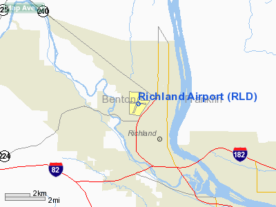
Richland Airport (IATA: RLD, ICAO: KRLD, FAA LID: RLD) is a public airport located two miles (3 km) northwest of the central business district of Richland, a city in Benton County, Washington, United States. It is owned by the Port of Benton.
Facilities and aircraft
Richland Airport covers an area of 564 acres (228 ha) which contains two asphalt paved runways: 1/19 measuring 4,009 x 75 ft (1,222 x 23 m) and 8/26 measuring 3,995 x 100 ft (1,218 x 30 m).
For the 12-month period ending July 31, 2007, the airport had 29,000 general aviation aircraft operations, an average of 79 per day. There are 202 aircraft based at this airport: 87% single-engine, 2% multi-engine, 1% helicopter, 4% glider and 6% ultralight.
The above content comes from Wikipedia and is published under free licenses – click here to read more.
Location & QuickFacts
| FAA Information Effective: | 2008-09-25 |
| Airport Identifier: | RLD |
| Airport Status: | Operational |
| Longitude/Latitude: | 119-18-15.1000W/46-18-20.3000N
-119.304194/46.305639 (Estimated) |
| Elevation: | 394 ft / 120.09 m (Surveyed) |
| Land: | 564 acres |
| From nearest city: | 2 nautical miles NW of Richland, WA |
| Location: | Benton County, WA |
| Magnetic Variation: | 17E (2005) |
Owner & Manager
| Ownership: | Publicly owned |
| Owner: | Port Of Benton |
| Address: | 3100 George Washington Way
Richland, WA 99352 |
| Phone number: | 509-375-3060 |
| Manager: | John Haakenson |
| Address: | 3100 George Washington Way
Richland, WA 99352 |
| Phone number: | 509-375-3060 |
Airport Operations and Facilities
| Airport Use: | Open to public |
| Wind indicator: | Yes |
| Segmented Circle: | Yes |
| Control Tower: | No |
| Lighting Schedule: | DUSK-DAWN
ACTVT MIRL RY 01/19, REIL RYS 01 & 19, MALS RY 19 & ODALS RY 08 - CTAF. VASI RY 26 & PAPI RYS 01,08, & 19 OPR 24 HRS. |
| Beacon Color: | Clear-Green (lighted land airport) |
| Landing fee charge: | No |
| Sectional chart: | Seattle |
| Region: | ANM - Northwest Mountain |
| Traffic Pattern Alt: | 800 ft |
| Boundary ARTCC: | ZSE - Seattle |
| Tie-in FSS: | SEA - Seattle |
| FSS on Airport: | No |
| FSS Toll Free: | 1-800-WX-BRIEF |
| NOTAMs Facility: | RLD (NOTAM-d service avaliable) |
| Federal Agreements: | NGPY |
Airport Communications
| CTAF: | 122.700 |
| Unicom: | 122.700 |
Airport Services
| Fuel available: | 100LLA
FUEL BY MAJOR CREDIT CARD - 24 HR AVAILABILITY. |
| Airframe Repair: | MINOR |
| Power Plant Repair: | MINOR |
| Bottled Oxygen: | NONE |
| Bulk Oxygen: | NONE |
Runway Information
Runway 01/19
| Dimension: | 4009 x 75 ft / 1221.9 x 22.9 m |
| Surface: | ASPH, Good Condition |
| Weight Limit: | Single wheel: 30000 lbs.
Dual wheel: 45000 lbs.
Dual tandem wheel: 70000 lbs. |
| Edge Lights: | Medium |
| |
Runway 01 |
Runway 19 |
| Longitude: | 119-18-30.4266W | 119-18-05.7601W |
| Latitude: | 46-17-59.8516N | 46-18-35.5415N |
| Elevation: | 391.00 ft | 389.00 ft |
| Alignment: | 26 | 127 |
| ILS Type: | | LOCALIZER
|
| Traffic Pattern: | Left | Right |
| Markings: | Non-precision instrument, Good Condition | Non-precision instrument, Good Condition |
| Crossing Height: | 30.00 ft | 30.00 ft |
| VASI: | 2-light PAPI on left side | 2-light PAPI on left side |
| Visual Glide Angle: | 3.00° | 3.00° |
| Approach lights: | | MALS |
| Runway End Identifier: | Yes | Yes |
| Obstruction: | 13 ft ant, 396.0 ft from runway, 258 ft right of centerline, 15:1 slope to clear
CLOSE-IN OBSTN GND. | 24 ft pole, 795.0 ft from runway, 444 ft left of centerline, 24:1 slope to clear |
|
Runway 08/26
| Dimension: | 3995 x 100 ft / 1217.7 x 30.5 m |
| Surface: | ASPH, Good Condition |
| Weight Limit: | Single wheel: 30000 lbs.
Dual wheel: 45000 lbs.
Dual tandem wheel: 70000 lbs. |
| Edge Lights: | Medium |
| |
Runway 08 |
Runway 26 |
| Longitude: | 119-18-40.3573W | 119-17-43.7062W |
| Latitude: | 46-18-24.7665N | 46-18-21.0296N |
| Elevation: | 394.00 ft | 387.00 ft |
| Alignment: | 95 | 127 |
| Traffic Pattern: | Left | Right |
| Markings: | Non-precision instrument, Good Condition | Non-precision instrument, Good Condition |
| Crossing Height: | 40.00 ft | 50.00 ft |
| VASI: | 2-light PAPI on left side | 4-box on left side |
| Visual Glide Angle: | 3.00° | 3.00° |
| Approach lights: | ODALS | |
| Obstruction: | 19 ft gnd, 511.0 ft from runway, 231 ft right of centerline, 16:1 slope to clear | 16 ft rr, 573.0 ft from runway, 23:1 slope to clear |
|
Radio Navigation Aids
| ID |
Type |
Name |
Ch |
Freq |
Var |
Dist |
| PD | NDB | Foris | | 230.00 | 20E | 43.8 nm |
| MW | NDB | Pelly | | 408.00 | 18E | 48.7 nm |
| PSC | VOR/DME | Pasco | 021X | 108.40 | 20E | 8.2 nm |
| ALW | VOR/DME | Walla Walla | 111X | 116.40 | 20E | 44.1 nm |
| PDT | VORTAC | Pendleton | 094X | 114.70 | 20E | 39.6 nm |
| YKM | VORTAC | Yakima | 107X | 116.00 | 21E | 49.8 nm |
Remarks
- RY 08 CLSD NIGHTS TO PART 135 OPNS.
- ROAD 550' WEST APCH END RY 08.
- RETRO-REFLECTIVE DEVICES ALONG TWYS.
Images and information placed above are from
http://www.airport-data.com/airport/RLD/
We thank them for the data!
| General Info
|
| Country |
United States
|
| State |
WASHINGTON
|
| FAA ID |
RLD
|
| Latitude |
46-18-20.286N
|
| Longitude |
119-18-15.067W
|
| Elevation |
391 feet
|
| Near City |
RICHLAND
|
We don't guarantee the information is fresh and accurate. The data may
be wrong or outdated.
For more up-to-date information please refer to other sources.
|
|


