|
|
 |
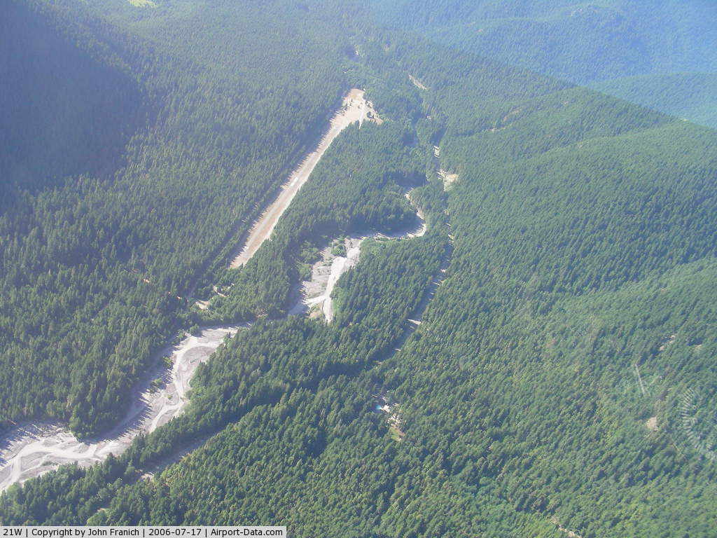
(Click on the photo to enlarge) |
Location & QuickFacts
| FAA Information Effective: | 2008-09-25 |
| Airport Identifier: | 21W |
| Airport Status: | Operational |
| Longitude/Latitude: | 121-32-01.3348W/47-00-46.3965N
-121.533704/47.012888 (Estimated) |
| Elevation: | 2650 ft / 807.72 m (Estimated) |
| Land: | 20 acres |
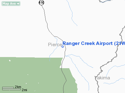
| From nearest city: | 10 nautical miles SE of Greenwater, WA |
| Location: | Pierce County, WA |
| Magnetic Variation: | 19E (1995) |
Owner & Manager
| Ownership: | Publicly owned |
| Owner: | Wsdot Aviation Div |
| Address: | 3704 172nd Street Ne, Suite K2, P.o. Box 3367
Arlington, WA 98223-6336 |
| Phone number: | 360-651-6300 |
| Manager: | Wsdot Aviation Div |
| Address: | 3704 172nd Street Ne, Suite K2, P.o. Box 3367
Arlington, WA 98223-6336 |
| Phone number: | 360-651-6300 |
Airport Operations and Facilities
| Airport Use: | Open to public |
| Segmented Circle: | No |
| Control Tower: | No |
| Sectional chart: | Seattle |
| Region: | ANM - Northwest Mountain |
| Boundary ARTCC: | ZSE - Seattle |
| Tie-in FSS: | SEA - Seattle |
| FSS on Airport: | No |
| FSS Toll Free: | 1-800-WX-BRIEF |
| NOTAMs Facility: | SEA (NOTAM-d service avaliable) |
Airport Communications
Runway Information
Runway 15/33
| Dimension: | 2875 x 30 ft / 876.3 x 9.1 m |
| Surface: | ASPH, Poor Condition
RY 15/33 PAVEMENT HAS CRACKS AND LOOSE ROCKS ON RUNWAY. |
| |
Runway 15 |
Runway 33 |
| Traffic Pattern: | Left | Left |
| Obstruction: | 56 ft trees, 200.0 ft from runway, 87 ft right of centerline
RY 15 +75 FT TREES 0-200 FT 97 FT R OF CNTRLN. | 31 ft trees, 223.0 ft from runway, 45 ft right of centerline
HAS +134 FT TREES FM 200 FT TO 0 FT 75 FT R OF CNTRLN & 45 FT TREES 55 FT L OF CNTRLN. |
|
Radio Navigation Aids
| ID |
Type |
Name |
Ch |
Freq |
Var |
Dist |
| ODD | NDB | Dondo | | 224.00 | 19E | 38.1 nm |
| RNT | NDB | Renton | | 353.00 | 20E | 40.2 nm |
| LAC | NDB | Lacomas | | 328.00 | 18E | 41.9 nm |
| GR | NDB | Graye | | 216.00 | 18E | 44.6 nm |
| TCM | VORTAC | Mcchord | 033X | 109.60 | 22E | 39.4 nm |
| SEA | VORTAC | Seattle | 115X | 116.80 | 19E | 40.6 nm |
| ELN | VORTAC | Ellensburg | 126X | 117.90 | 21E | 44.1 nm |
| SEA | VOT | Seattle-tacoma | | 117.50 | | 40.7 nm |
| BFI | VOT | Boeing Field | | 108.60 | | 44.1 nm |
Remarks
- CLSD OCT 1 TO JUN 1.
- DENSITY ALTITUDE ARPT.
- PEDESTRIANS; VEHICLES & ANIMALS MAY BE ON RY.
- CTC WASHINGTON STATE DIVISION OF AERONAUTICS 360-651-6300 OR 800-552-0666 FOR FACILITY INFORMATION PRIOR TO USE.
- TREES ALONG SIDES OF RY.
- USFS CAMPGROUNDS E & N OF RY.
Images and information placed above are from
http://www.airport-data.com/airport/21W/
We thank them for the data!
| General Info
|
| Country |
United States
|
| State |
WASHINGTON
|
| FAA ID |
21W
|
| Latitude |
47-00-46.397N
|
| Longitude |
121-32-01.335W
|
| Elevation |
2650 feet
|
| Near City |
GREENWATER
|
We don't guarantee the information is fresh and accurate. The data may
be wrong or outdated.
For more up-to-date information please refer to other sources.
|
|