 |
|
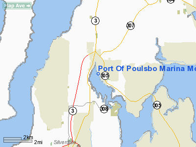
Port Of Poulsbo Marina Moorage Seaplane Base Airport |
Location & QuickFacts
| FAA Information Effective: | 2008-09-25 |
| Airport Identifier: | 83Q |
| Airport Status: | Operational |
| Longitude/Latitude: | 122-38-50.5330W/47-44-02.3400N
-122.647370/47.733983 (Estimated) |
| Elevation: | 0 ft / 0.00 m (Estimated) |
| Land: | 0 acres |
| From nearest city: | 0 nautical miles N of Poulsbo, WA |
| Location: | Kitsap County, WA |
| Magnetic Variation: | 20E (1985) |
Owner & Manager
| Ownership: | Publicly owned |
| Owner: | Port Of Poulsbo
TIDELANDS ARE OWNED BY STATE OF WA AND LEASED TO PORT. |
| Address: | Po Box 732
Poulsbo, WA 98370 |
| Phone number: | 360-779-3505 |
| Manager: | Kirk Stickels |
| Address: | Po Box 732
Poulsbo, WA 98370 |
| Phone number: | 360-779-9905 |
Airport Operations and Facilities
| Airport Use: | Open to public |
| Segmented Circle: | No |
| Control Tower: | No |
| Sectional chart: | Seattle |
| Region: | ANM - Northwest Mountain |
| Boundary ARTCC: | ZSE - Seattle |
| Tie-in FSS: | SEA - Seattle |
| FSS Toll Free: | 1-800-WX-BRIEF |
| NOTAMs Facility: | SEA (NOTAM-d service avaliable) |
Airport Communications
Runway Information
Runway 13/31
| Dimension: | 12000 x 4000 ft / 3657.6 x 1219.2 m |
| Surface: | WATER, |
| |
Runway 13 |
Runway 31 |
| Traffic Pattern: | Left | Left |
|
Radio Navigation Aids
| ID |
Type |
Name |
Ch |
Freq |
Var |
Dist |
| PWT | NDB | Kitsap | | 206.00 | 20E | 15.2 nm |
| CAN | NDB | Carney | | 274.00 | 20E | 20.9 nm |
| RNT | NDB | Renton | | 353.00 | 20E | 22.6 nm |
| ODD | NDB | Dondo | | 224.00 | 19E | 26.1 nm |
| MNC | NDB | Mason County | | 348.00 | 19E | 34.2 nm |
| GR | NDB | Graye | | 216.00 | 18E | 35.1 nm |
| LAC | NDB | Lacomas | | 328.00 | 18E | 43.8 nm |
| BVS | NDB | Skagit/bay View | | 240.00 | 21E | 45.1 nm |
| OPZ | NDB | Lopez Island | | 356.00 | 21E | 46.1 nm |
| CL | NDB | Elwha | | 515.00 | 22E | 48.2 nm |
| NUW | TACAN | Whidbey Island | 085X | | 21E | 37.3 nm |
| PAE | VOR/DME | Paine | 043X | 110.60 | 20E | 18.6 nm |
| CVV | VOR/DME | Penn Cove | 119X | 117.20 | 19E | 30.9 nm |
| SEA | VORTAC | Seattle | 115X | 116.80 | 19E | 22.6 nm |
| TCM | VORTAC | Mcchord | 033X | 109.60 | 22E | 35.9 nm |
| OLM | VORTAC | Olympia | 081X | 113.40 | 19E | 47.0 nm |
| BFI | VOT | Boeing Field | | 108.60 | | 18.7 nm |
| SEA | VOT | Seattle-tacoma | | 117.50 | | 22.4 nm |
Remarks
- ORANGE BUOY 100 FT SW OF TSNT DOCK MARKS LOW TIDE ROCKS.
Images and information placed above are from
http://www.airport-data.com/airport/83Q/
We thank them for the data!
| General Info
|
| Country |
United States
|
| State |
WASHINGTON
|
| FAA ID |
83Q
|
| Latitude |
47-44-02.340N
|
| Longitude |
122-38-50.533W
|
| Elevation |
0 feet
|
| Near City |
POULSBO
|
We don't guarantee the information is fresh and accurate. The data may
be wrong or outdated.
For more up-to-date information please refer to other sources.
|
|


