|
|
| Pearson Field |
 |
| IATA: none – ICAO: KVUO – FAA LID: VUO |
| Summary |
| Airport type |
Public |
| Owner |
City of Vancouver |
| Serves |
Vancouver, Washington |
| Elevation AMSL |
25 ft / 8 m |
| Coordinates |
45°37′14″N 122°39′23″W / 45.62056°N 122.65639°W / 45.62056; -122.65639 |
| Runways |
| Direction |
Length |
Surface |
| ft |
m |
| 8/26 |
3,275 |
998 |
Asphalt |
| Statistics (2006) |
| Aircraft operations |
52,200 |
| Based aircraft |
175 |
| Source: Federal Aviation Administration |
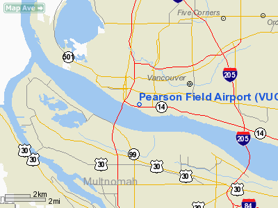
Pearson Field (ICAO: KVUO, FAA LID: VUO), is a city-owned public-use airport located one mile (2 km) southeast of the central business district of Vancouver, a city in Clark County, Washington, United States.
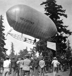
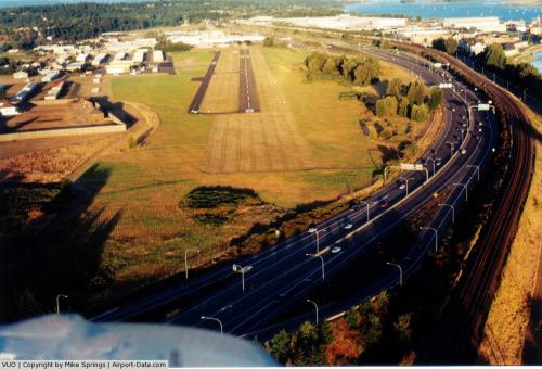
Pearson Field is the oldest operating airfield in the United States dating to the landing of the dirigible Gelatine, piloted by Lincoln Beachey, upon the polo grounds of the Vancouver Barracks in 1905.. Located in the Fort Vancouver National Historic Site, it is also the only airport in the United States that operates totally within the boundaries of a national historic reserve. Primarily used for general aviation, the airfield's lone runway is located directly beneath the final approach to nearby Portland International Airport. The airport lies next to the Lewis and Clark Highway and the Columbia River. It is the only airport in Washington that is a satellite airport.
Although most U.S. airports use the same three-letter location identifier for the FAA and IATA, Pearson Field is assigned VUO by the FAA but has no designation from the IATA. History
Pearson Field's history dates back to the early 1900s and is named for local resident First Lieutenant Alexander Pearson Jr. of the United States Army.
- 1905
- Lincoln Beachey pilots the dirigible Gelatine from the grounds of the 1905 Lewis and Clark Centennial Exposition on the shores of Guild Lake in Portland, Oregon to Vancouver Barracks in the first aerial crossing of the Columbia River. This flight also set an endurance record for flight at the time. Carrying a letter from Theodore Hardee, an official of the fair, to the commandant of the Vancouver Barracks, General Constant Williams, the flight is also the recognized as the first time an airship is used to deliver a letter.
- 1911
- First airplane lands at Pearson Field.
 | |
Lincoln Beachey flying the Gelatine Circa 1905 |
- 1923-1941
- Pearson Field is home to the US Army Air Service.
- 1923
- Commander Lt. Oakley Kelly makes the first non-stop transcontinental flight.
- 1924
- Pearson Field is a stopover point on the army's first round-the-world flight.
- 1925
- Pearson Field is named after Lt. Alexander Pearson by order of Major General John L. Hines
- 1937
- Soviet aviator Valery Chkalov lands at the end of the first non-stop transpolar flight.
- 1994
- City of Vancouver and National Park Service enter into agreement governing the future of Pearson Field.
- 2005
- Pearson Field celebrates its 100-year anniversary.
Facilities and aircraft
Pearson Field covers an area of 140 acres (57 ha) which contains one runway designated 8/26 with a 3,275 x 60 ft (998 x 18 m) asphalt pavement. For the 12-month period ending May 31, 2006, the airport had 52,200 aircraft operations, an average of 143 per day: 97% general aviation, 2% military and 1% air taxi. At that time there were 175 aircraft based at this airport: 97% single-engine and 3% multi-engine.
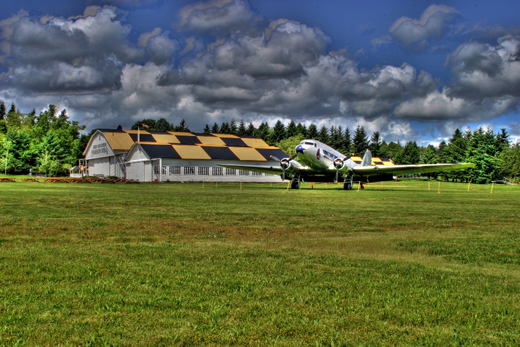
The airfield has a 150 T-hangars and tiedown facilities, with capacity for 175 light aircraft. Located at the airport are the Pearson Air Museum and the Jack Murdock Aviation Center. Located nearby are the Jantzen Beach SuperCenter and the Portland International Raceway.
Transportation
- Lewis and Clark Highway (State Route 14)
- Interstate 5
Economic impact
The state of Washington provides economic impact studies of airports within the state. Pearson Field contributes about 600 jobs to the area. Salaries drawn in relation to business at Pearson total about $11M USD. The total economic activity related to Pearson totals about $38M USD.
The above content comes from Wikipedia and is published under free licenses – click here to read more.
 |
(Click on the photo to enlarge) |
Location & QuickFacts
| FAA Information Effective: | 2008-09-25 |
| Airport Identifier: | VUO |
| Airport Status: | Operational |
| Longitude/Latitude: | 122-39-23.3580W/45-37-13.6290N
-122.656488/45.620452 (Estimated) |
| Elevation: | 25 ft / 7.62 m (Surveyed) |
| Land: | 140 acres |
| From nearest city: | 2 nautical miles SW of Vancouver, WA |
| Location: | Clark County, WA |
| Magnetic Variation: | 19E (1985) |
Owner & Manager
| Ownership: | Publicly owned
CITY OF VANCOUVER AND NPS. |
| Owner: | City Of Vancouver |
| Address: | Po Box 1995
Vancouver, WA 98660 |
| Phone number: | 360-619-1295 |
| Manager: | F.t. Willy Williamson |
| Address: | Po Box 1995
Vancouver, WA 98660 |
| Phone number: | 360-619-1295 |
Airport Operations and Facilities
| Airport Use: | Open to public |
| Wind indicator: | Yes |
| Segmented Circle: | Yes |
| Control Tower: | No |
| Lighting Schedule: | DUSK-DAWN |
| Landing fee charge: | No |
| Sectional chart: | Seattle |
| Region: | ANM - Northwest Mountain |
| Traffic Pattern Alt: | 1000 ft |
| Boundary ARTCC: | ZSE - Seattle |
| Tie-in FSS: | SEA - Seattle |
| FSS on Airport: | No |
| FSS Toll Free: | 1-800-WX-BRIEF |
| NOTAMs Facility: | VUO (NOTAM-d service avaliable) |
| Federal Agreements: | NGPY |
Airport Communications
| CTAF: | 123.000 |
| Unicom: | 123.000 |
Airport Services
| Fuel available: | 100LL
SELF SERVICE FUEL AVBL 24 HRS BY CREDIT CARD. |
| Airframe Repair: | MAJOR |
| Power Plant Repair: | MAJOR |
| Bottled Oxygen: | NONE |
| Bulk Oxygen: | LOW |
Runway Information
Runway 08/26
| Dimension: | 3275 x 60 ft / 998.2 x 18.3 m
RWY 08/26 860 FT STOPWAY ON WEST END. |
| Surface: | ASPH, Good Condition |
| Weight Limit: | Single wheel: 10000 lbs. |
| Edge Lights: | Medium
RY 08 THR RELOCATED 762 FT FOR NIGHT OPERATIONS; 2513 FT OF RY 08/26 LGTD AT NIGHT. |
| |
Runway 08 |
Runway 26 |
| Longitude: | 122-39-46.1640W | 122-39-00.5520W |
| Latitude: | 45-37-15.9340N | 45-37-11.3230N |
| Elevation: | 25.00 ft | 19.00 ft |
| Alignment: | 98 | 127 |
| Traffic Pattern: | Left | Right |
| Markings: | Basic, Good Condition | Basic, Good Condition |
| Crossing Height: | 31.00 ft | 0.00 ft |
| Displaced threshold: | 0.00 ft | 762.00 ft |
| VASI: | 4-box on right side
VASI RY 08 UNUSBL BYD 6 DEG L & R OF RY CENTERLINE. | 2-light PAPI on right side |
| Visual Glide Angle: | 3.75° | 0.00° |
| Runway End Identifier: | Yes | Yes |
| Obstruction: | 218 ft brdg, 2647.0 ft from runway, 482 ft right of centerline, 11:1 slope to clear
+8' POLE AT 100', 170' R. | 36 ft tree, 1056.0 ft from runway, 23:1 slope to clear
APCH SLOPE 44:1 AT DSPLCD THR.
+18' POLES MARKED & LGTD AT 50'; +16' DIKE AT 115'. |
| Decleard distances: | Take off run available 3275.00 ft
Take off distance available 3275.00 ft
Actual stop distance available 3065.00 ft
Landing distance available 3065.00 ft
| Take off run available 3275.00 ft
Take off distance available 3275.00 ft
Actual stop distance available 3275.00 ft
Landing distance available 2513.00 ft
|
|
Radio Navigation Aids
| ID |
Type |
Name |
Ch |
Freq |
Var |
Dist |
| LBH | NDB | Laker | | 332.00 | 20E | 9.5 nm |
| PND | NDB | Banks | | 356.00 | 21E | 16.4 nm |
| LSO | NDB | Kelso | | 256.00 | 21E | 33.9 nm |
| PEN | NDB | Karpen | | 201.00 | 20E | 49.9 nm |
| CBU | TACAN | Columbia | 029X | | 20E | 2.7 nm |
| PDX | VOR/DME | Portland | 055X | 111.80 | 20E | 2.7 nm |
| UBG | VOR/DME | Newberg | 121X | 117.40 | 21E | 21.0 nm |
| BTG | VORTAC | Battle Ground | 113X | 116.60 | 21E | 8.1 nm |
| PDX | VOT | Portland Intl | | 111.00 | | 2.7 nm |
| HIO | VOT | Portland-hillsboro | | 115.20 | | 13.2 nm |
Remarks
- WHEN OPERG OVER THE RY CNTRLN OR RY CNTRLN EXTDD - MAINTAIN AT OR BLO 700 FT MSL DUE TO TFC & WAKE TURBULENCE FROM OVERFLYING ACFT TO/FROM PORTLAND INTERNATIONAL ARPT (PDX) RY 10L/28R. PDX RY 10L/28R EXTDD CNTRLN CROSSES PEARSON RY 08 THLD.
Images and information placed above are from
http://www.airport-data.com/airport/VUO/
We thank them for the data!
| General Info
|
| Country |
United States
|
| State |
WASHINGTON
|
| FAA ID |
VUO
|
| Latitude |
45-37-13.629N
|
| Longitude |
122-39-23.358W
|
| Elevation |
25 feet
|
| Near City |
VANCOUVER
|
We don't guarantee the information is fresh and accurate. The data may
be wrong or outdated.
For more up-to-date information please refer to other sources.
|
|