 |
|
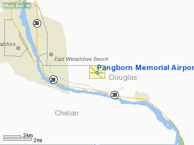
Pangborn Memorial Airport |
| Pangborn Memorial Airport |
| IATA: EAT – ICAO: KEAT – FAA LID: EAT |
| Summary |
| Airport type |
Public |
| Owner |
Ports of Chelan and Douglas Counties |
| Serves |
Wenatchee, Washington |
| Elevation AMSL |
1,249 ft / 381 m |
| Coordinates |
47°23′53″N 120°12′21″W / 47.39806°N 120.20583°W / 47.39806; -120.20583 |
| Runways |
| Direction |
Length |
Surface |
| ft |
m |
| 7/25 |
4,460 |
1,359 |
Asphalt |
| 12/30 |
5,700 |
1,737 |
Asphalt |
| Statistics (2008) |
| Aircraft operations |
44,681 |
| Based aircraft |
132 |
| Source: Federal Aviation Administration |
Pangborn Memorial Airport (IATA: EAT, ICAO: KEAT, FAA LID: EAT) is a public use airport in Douglas County, Washington, United States. It is located four nautical miles (7 km) east of the central business district of Wenatchee, a city in Chelan County. The airport is owned by the Ports of Chelan and Douglas Counties.
The airport is mostly used for general aviation, but is also served by one commercial airline (Horizon Air) providing commuter service to Seattle-Tacoma International. As of September 28th, 2006, Pangborn Memorial began supporting ILS (Instrument Landing System) approaches.
Pangborn Memorial Airport is named for Clyde Pangborn, who in 1931 became the first person to fly non-stop across the Pacific Ocean. Taking off from Misawa, Aomori, Japan with an intended destination of Seattle, he instead landed in Wenatchee. Facilities and aircraft
Pangborn Memorial Airport covers an area of 585 acres (237 ha) at an elevation of 1,249 feet (381 m) above mean sea level. It has two asphalt paved runways: 12/30 is 5,700 by 150 feet (1,737 x 46 m) and 7/25 is 4,460 by 75 feet (1,359 x 23 m).
For the 12-month period ending December 31, 2008, the airport had 44,681 aircraft operations, an average of 122 per day: 69% general aviation, 29% air taxi, 2% scheduled commercial and <1% military. At that time there were 132 aircraft based at this airport: 67% single-engine, 9% multi-engine, 10% jet, 2% helicopter, 11% glider and 1% ultralight.
Airline and destination
| Airlines |
Destinations |
| Horizon Air |
Seattle/Tacoma |
The above content comes from Wikipedia and is published under free licenses – click here to read more.
Location & QuickFacts
| FAA Information Effective: | 2008-09-25 |
| Airport Identifier: | EAT |
| Airport Status: | Operational |
| Longitude/Latitude: | 120-12-20.6547W/47-23-53.1213N
-120.205737/47.398089 (Estimated) |
| Elevation: | 1249 ft / 380.70 m (Surveyed) |
| Land: | 585 acres |
| From nearest city: | 4 nautical miles E of Wenatchee, WA |
| Location: | Douglas County, WA |
| Magnetic Variation: | 19E (1995) |
Owner & Manager
| Ownership: | Publicly owned |
| Owner: | Ports Chelan&douglas Cnty |
| Address: | One Pangborn Drive
East Wenatchee, WA 98802 |
| Phone number: | 509-884-2494 |
| Manager: | Patricia A. Moore |
| Address: | One Pangborn Drive
East Wenatchee, WA 98802 |
| Phone number: | 509-884-2494 |
Airport Operations and Facilities
| Airport Use: | Open to public |
| Wind indicator: | Yes |
| Segmented Circle: | Yes |
| Control Tower: | No |
| Lighting Schedule: | DUSK-DAWN
ACTVT MIRL RY 12/30 & REIL RYS 12 & 30 - CTAF. |
| Beacon Color: | Clear-Green (lighted land airport) |
| Landing fee charge: | No |
| Sectional chart: | Seattle |
| Region: | ANM - Northwest Mountain |
| Boundary ARTCC: | ZSE - Seattle |
| Tie-in FSS: | SEA - Seattle |
| FSS on Airport: | No |
| FSS Toll Free: | 1-800-WX-BRIEF |
| NOTAMs Facility: | EAT (NOTAM-d service avaliable) |
| Certification type/date: | I A S 05/1973
24 HR PPR FOR UNSKED ACR OPNS WITH MORE THAN 30 PSGR SEATS CALL AMGR 509-884-2494. |
| Federal Agreements: | NGY3 |
Airport Communications
| CTAF: | 123.000 |
| Unicom: | 123.000 |
Airport Services
| Fuel available: | 100LLA |
| Airframe Repair: | MAJOR |
| Power Plant Repair: | MAJOR |
| Bottled Oxygen: | NONE |
| Bulk Oxygen: | HIGH/LOW |
Runway Information
Runway 07/25
| Dimension: | 4460 x 75 ft / 1359.4 x 22.9 m |
| Surface: | ASPH, Poor Condition
RUNWAY 7/25 HAS EXTENSIVE CRACKS, VEGATATION, AND SURFACE DETERIORATION. |
| Weight Limit: | Single wheel: 50000 lbs.
Dual wheel: 77000 lbs.
Dual tandem wheel: 136000 lbs. |
| |
Runway 07 |
Runway 25 |
| Longitude: | 120-12-54.4936W | 120-11-49.6649W |
| Latitude: | 47-23-54.9363N | 47-23-54.9138N |
| Elevation: | 1205.00 ft | 1249.00 ft |
| Alignment: | 90 | 127 |
| Traffic Pattern: | Right | Left |
| Markings: | Basic, Poor Condition
RUNWAY MARKINGS ARE FADED AND OBSCURED | Basic, Poor Condition
RUNWAY MARKINGS ARE FADED AND OBSCURED |
| Obstruction: | 25 ft tree, 1000.0 ft from runway, 32:1 slope to clear | , 50:1 slope to clear |
|
Runway 12/30
| Dimension: | 5700 x 150 ft / 1737.4 x 45.7 m |
| Surface: | ASPH, Good Condition
RUNWAY 7/25 HAS EXTENSIVE CRACKS, VEGATATION, AND SURFACE DETERIORATION. |
| Surface Treatment: | Saw-cut or plastic Grooved |
| Weight Limit: | Single wheel: 50000 lbs.
Dual wheel: 77000 lbs.
Dual tandem wheel: 136000 lbs. |
| Edge Lights: | Medium |
| |
Runway 12 |
Runway 30 |
| Longitude: | 120-12-48.8200W | 120-11-50.2600W |
| Latitude: | 47-24-11.6100N | 47-23-31.8100N |
| Elevation: | 1221.00 ft | 1231.00 ft |
| Alignment: | 127 | 127 |
| ILS Type: | ILS/DME
| |
| Traffic Pattern: | Right | Left |
| Markings: | Precision instrument, Good Condition | Non-precision instrument, Good Condition |
| Crossing Height: | 50.00 ft | 0.00 ft |
| VASI: | 4-light PAPI on left side | |
| Visual Glide Angle: | 3.60° | 0.00° |
| Runway End Identifier: | Yes | Yes |
| Obstruction: | 18 ft road, 500.0 ft from runway, 280 ft left of centerline, 16:1 slope to clear | , 50:1 slope to clear |
| Decleard distances: | Take off run available 5700.00 ft
Take off distance available 5700.00 ft
Actual stop distance available 5700.00 ft
Landing distance available 5700.00 ft
| Take off run available 5700.00 ft
Take off distance available 5700.00 ft
Actual stop distance available 5700.00 ft
Landing distance available 5700.00 ft
|
|
Radio Navigation Aids
| ID |
Type |
Name |
Ch |
Freq |
Var |
Dist |
| EAT | FAN MARKER | Malaga | | | 21E | 3.6 nm |
| MW | NDB | Pelly | | 408.00 | 18E | 41.6 nm |
| EAT | VOR/DME | Wenatchee | 047X | 111.00 | 19E | 0.2 nm |
| MWH | VOR/DME | Moses Lake | 097X | 115.00 | 18E | 37.9 nm |
| ELN | VORTAC | Ellensburg | 126X | 117.90 | 21E | 24.7 nm |
| EPH | VORTAC | Ephrata | 073X | 112.60 | 21E | 31.8 nm |
Remarks
- RY 07/25 CLSD WHEN SNOW ON THE GROUND.
- GLIDER ACTIVITY FROM MAR-NOV.
- RY 12 PREFERRED NO WIND RY.
- TWYS D & E CLOSED WHEN SNOW ON THE GROUND
- ESTABD PRIOR TO 15 MAY 1959.
Images and information placed above are from
http://www.airport-data.com/airport/EAT/
We thank them for the data!
| General Info
|
| Country |
United States
|
| State |
WASHINGTON
|
| FAA ID |
EAT
|
| Latitude |
47-23-55.900N
|
| Longitude |
120-12-24.600W
|
| Elevation |
1249 feet
|
| Near City |
WENATCHEE
|
We don't guarantee the information is fresh and accurate. The data may
be wrong or outdated.
For more up-to-date information please refer to other sources.
|
|


