|
|
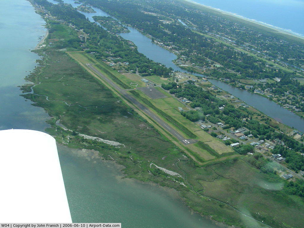
Ocean Shores Muni Airport |
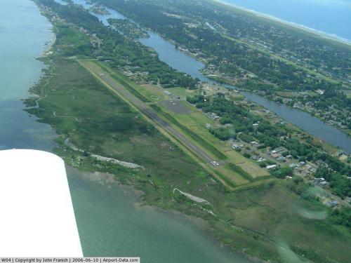 |
(Click on the photo to enlarge) |
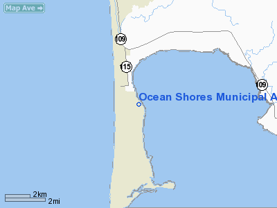
Location & QuickFacts
| FAA Information Effective: | 2008-09-25 |
| Airport Identifier: | W04 |
| Airport Status: | Operational |
| Longitude/Latitude: | 124-08-37.6260W/47-00-13.3130N
-124.143785/47.003698 (Estimated) |
| Elevation: | 13 ft / 3.96 m (Surveyed) |
| Land: | 49 acres |
| From nearest city: | 2 nautical miles NE of Ocean Shores, WA |
| Location: | Grays Harbor County, WA |
| Magnetic Variation: | 20E (1985) |
Owner & Manager
| Ownership: | Publicly owned |
| Owner: | City Of Ocean Shores |
| Address: | City Hall
Ocean Shores, WA 98569 |
| Phone number: | 360-289-2486 |
| Manager: | Ken Lanfier |
| Address: | 2754 Pt Brown Ave Nw
Ocean Shores, WA 98569 |
| Phone number: | 360-289-2754 |
Airport Operations and Facilities
| Airport Use: | Open to public |
| Wind indicator: | Yes |
| Segmented Circle: | Yes |
| Control Tower: | No |
| Lighting Schedule: | DUSK-DAWN
ACTVT LIRL RY 15/33 & SAVASI RYS 15 & 33 - 122.8. |
| Beacon Color: | Clear-Green (lighted land airport) |
| Landing fee charge: | No |
| Sectional chart: | Seattle |
| Region: | ANM - Northwest Mountain |
| Boundary ARTCC: | ZSE - Seattle |
| Tie-in FSS: | SEA - Seattle |
| FSS on Airport: | No |
| FSS Toll Free: | 1-800-WX-BRIEF |
| NOTAMs Facility: | SEA (NOTAM-d service avaliable) |
| Federal Agreements: | N |
Airport Communications
Airport Services
Runway Information
Runway 15/33
| Dimension: | 2700 x 50 ft / 823.0 x 15.2 m
HAS ASPH 50 FT WIDE WITH 12.5 FT GRVL SHOLDERS. |
| Surface: | ASPH, Good Condition |
| Weight Limit: | Single wheel: 12500 lbs. |
| Edge Lights: | Low |
| |
Runway 15 |
Runway 33 |
| Traffic Pattern: | Left | Right |
| Markings: | Basic, Good Condition | Basic, Good Condition |
| Crossing Height: | 22.00 ft | 22.00 ft |
| VASI: | 2-box SAVASI on left side | 2-box SAVASI on left side |
| Visual Glide Angle: | 3.50° | 3.50° |
| Obstruction: | , 50:1 slope to clear | 35 ft trees, 832.0 ft from runway, 120 ft left of centerline, 18:1 slope to clear |
|
Radio Navigation Aids
| ID |
Type |
Name |
Ch |
Freq |
Var |
Dist |
| AST | FAN MARKER | Fort Stevens | | | 22E | 48.4 nm |
| MNC | NDB | Mason County | | 348.00 | 19E | 45.7 nm |
| HQM | VORTAC | Hoquiam | 124X | 117.70 | 19E | 3.4 nm |
Remarks
- PARKING RAMP LOOSE GRAVEL ON SURFACE.
- SEABIRDS IN SAFETY & TAXI AREAS AND ADJACENT WETLANDS.
- TWYS VERY SOFT WHEN WET.
Images and information placed above are from
http://www.airport-data.com/airport/W04/
We thank them for the data!
| General Info
|
| Country |
United States
|
| State |
WASHINGTON
|
| FAA ID |
W04
|
| Latitude |
47-00-13.313N
|
| Longitude |
124-08-37.626W
|
| Elevation |
13 feet
|
| Near City |
OCEAN SHORES
|
We don't guarantee the information is fresh and accurate. The data may
be wrong or outdated.
For more up-to-date information please refer to other sources.
|
|