|
 |
|
||||
|
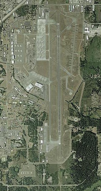
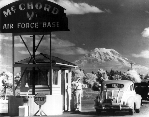
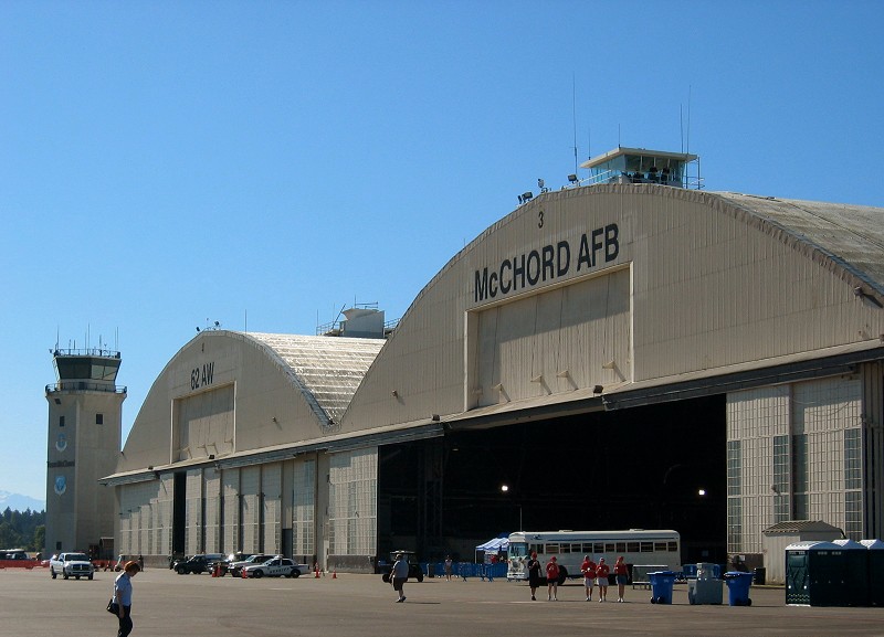
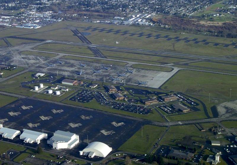
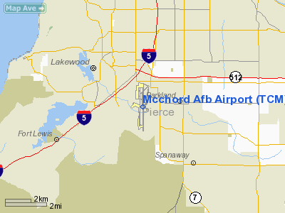
JBLM McChord Field (IATA: TCM, ICAO: KTCM, FAA LID: TCM) is a United States Air Force base in Pierce County, Washington, United States. It was formerly named McChord Air Force Base and is now part of the larger Joint Base Lewis-McChord. It is located adjacent to Lakewood, about one mile south of Tacoma and 40 miles south of Seattle. It was named in honor of Colonel William Caldwell McChord, former Chief of the Training and Operations Division in HQ Army Air Corps. Much of the base is a census-designated place (CDP), which had a population of 4,096 at the 2000 census. Its primary mission is military airlift and is assigned to Air Mobility Command. The McChord Field Historic District was listed on the U.S. National Register of Historic Places on December 12, 2008. UnitsMcChord is home to a wide variety of units and missions. The 62nd Airlift Wing is the active duty host wing on McChord. The 62nd Airlift Wing is joined by its Reserve partner the 446th Airlift Wing. Together, the two wings fly 50 C-17 Globemaster IIIs to provide combat airlift for America. McChord also hosts the Western Air Defense Sector, an Air National Guard unit; the 22nd Special Tactics Squadron; the 361st Recruiting Squadron and a number of other units. The McChord Air Museum is one of the largest and finest military aircraft museums in the United States. HistoryIn 1917, the citizens of Pierce County, Washington approved a bond measure for $2,000,000 to buy 70,000 acres (280 km²) of land to be donated to the Federal Government for use as a military reservation. This land became Camp Lewis (and later Fort Lewis). Ten years later, in 1927, another bond measure was passed to establish an airfield just north of the military reservation. The airfield, named Tacoma Field, officially opened March 14, 1930. On February 28, 1938 the airfield was officially transferred to the United States Government. Three years after the transfer, on July 3, 1940, the airfield was renamed McChord Field, in honor of Colonel William Caldwell McChord, who had been killed in an accident near Richmond, Virginia on August 18, 1937. Col. McChord, (1881–1937), rated as a junior military aviator in 1918, died while trying to force-land his Northrop A-17 near Maidens, Virginia. At the time of his death, he was Chief of the Training and Operations Division in HQ Army Air Corps. Tacoma Field was renamed McChord Field, 17 December 1937. Over the subsequent two decades McChord Field grew to roughly 3,000 acres (12 km²), encompassing the northern tip of the 70,000 acre (280 km²) Ft. Lewis. It became independent of Ft. Lewis in 1947 following the creation of the Air Force under provisions of the National Security Act of 1947 and was subsequently named McChord AFB. On February 1, 2010 it again joined with Ft. Lewis to become Joint Base Lewis-McChord. This initiative was driven by the Base Realignment and Closure Round in 2005 and is designed to combine current infrastructure into one maximizing war fighting capability and efficiency, while saving taxpayer dollars. Major commands to which assigned
Major units assignedOperational history
After the Japanese attack on Pearl Harbor, McChord was camouflaged and windows were blacked out. Squadrons of P-40 and P-43 fighters were assigned to the field. In addition to training pilots, McChord was a clearing station for planes and crews headed for Alaska and the war in the Pacific. Following the end of the war in Europe, McChord redeployed thousands of troops arriving from the European theater to the Pacific. In 1948, the field was re-designated McChord Air Force Base. McChord was instrumental in the development of the Alaskan air defense system. In 1950, McChord became part of the Air Defense Command (ADC). In 1968, the base was relieved of its assignment to the subsequently renamed Aerospace Defense Command when it was turned over to the Military Airlift Command (MAC) as one of three MAC bases in the western United States operating the C-141 Starlifter. ADC, and later Tactical Air Command (TAC) continued to maintain a fighter alert detachment at McChord with F-106 Delta Dart and later F-15 Eagle aircraft. In 1975, TAC divested itself of its C-130 Hercules tactical airlift fleet, transferring all tactical airlift wings, groups and squadrons to MAC. For the 62 AW, this resulted in a significant increase in the wing's total mission capabilities beyond strictly strategic airlift with the arrival of the 36th Tactical Airlift Squadron (36 TAS) and their C-130E aircraft and personnel from Langley AFB, VA. In 1980, following the eruption of Mount St. Helens, a 36 TAS C-130 crew provided communications support during the search for survivors. One week after St Helen's first eruption, a second one occurred. All of the base's flyable aircraft were evacuated following reports that ash was drifting northwest toward McChord. In 1988 McChord became involved in combating devastating Yellowstone National Park forest fires, carrying troops from Fort Lewis to the fire areas. In 1991, Clark Air Base in the Philippines was evacuated due to the eruption of Mount Pinatubo. By June 16, the evacuation order was issued and the first plane load of evacuees arrived at McChord on the 18th. In 1992, with the disestablishment of Military Airlift Command, McChord became an Air Mobility Command base. In November of that same year, two McChord C-141 Starlifters, participating in an air refueling training mission over north central Montana, collided in mid-air, killing all 13 crewmen. As the C-141 was phased out at McChord, it was replaced with the C-17 Globemaster III. McChord AFB and its 62 AW was the second AMC base to receive this aircraft for active duty, the first having been the 437th Airlift Wing (437 AW) at Charleston AFB, South Carolina. McChord has been the host base for the Air Mobility Rodeo in 1998, 2005, 2007 and 2009. On February 1, 2010 it again joined with Ft. Lewis to become Joint Base Lewis-McChord, per BRAC 2005. Like most US military installations, JBLM is closed to the general public, other than during their annual Open House. There is a museum on the base, however, it cannot be visited by the public without prior coordination due to lack of public access. GeographyJoint Base Lewis McChord is at 47°8′17″N 122°29′58″W / 47.13806°N 122.49944°WCoordinates: 47°8′17″N 122°29′58″W / 47.13806°N 122.49944°W. According to the United States Census Bureau, it has a total area of 15.0 km² (5.8 mi²). 15.0 km² (5.8 mi²) of it is land and none of the area is covered with water. DemographicsAs of the census of 2000, there were 4,096 people, 1,004 households, and 978 families residing on the base. The population density was 272.7/km² (706.5/mi²). There were 1,010 housing units, with an average density of 67.2/km² (174.2/mi²). The racial makeup was 76.49% White, 8.54% African American, 0.73% Native American, 4.15% Asian, 0.66% Pacific Islander, 3.17% from other races, and 6.25% from two or more races. 8.08% of the population were Hispanic or Latino of any race. There were 1,004 households out of which 77.7% had children under the age of 18 living with them, 89.9% were married couples living together, 4.4% had a female householder with no husband present, and 2.5% were non-families. 2.0% of all households were made up of individuals. The average household size was 3.46 and the average family size was 3.49. On the base the population was spread out with 36.3% under the age of 18, 22.2% from 18 to 24, 39.5% from 25 to 44, 1.8% from 45 to 64, and 0.1% who were 65 years of age or older. The median age wes 22 years. For every 100 females there were 127.1 males. For every 100 females age 18 and over, there were 137.1 males. The median income for a household was $35,319, and the median income for a family was $35,205. Males have a median income of $23,004 versus $22,216 for females. The per capita income for the base was $12,454. About 5.5% of families and 7.3% of the population were below the poverty line, including 9.5% of those under the age of 18 and none of those 65 and older. Base Realignment, 2005The Department of Defense proposed a major realignment of the base as part of the Base Realignment and Closure program announced on May 13, 2005 which went into effect on February 1, 2010. The above content comes from Wikipedia and is published under free licenses – click here to read more.
Location & QuickFacts
Owner & Manager
Airport Operations and Facilities
Airport Services
Runway InformationRunway 16/34
Runway 160/340
Radio Navigation Aids
Remarks
Images and information placed above are from We thank them for the data!
We don't guarantee the information is fresh and accurate. The data may
be wrong or outdated.
|
|||||||||||||||||||||||||||||||||||||||||||||||||||||||||||||||||||||||||||||||||||||||||||||||||||||||||||||||||||||||||||||||||||||||||||||||||||||||||||||||||||||||||||||||||||||||||||||||||||||||||||||||||||||||||||||||||||||||||||||||||||||||||||||||||||||||||||||||||||||||||||||||||||||||||||||||||||||||||||||||||||||||||||||||||||||||||||||||||||||||||||||||||||

 |
|
Copyright 2004-2024 © by Airports-Worldwide.com, Vyshenskoho st. 36, Lviv 79010, Ukraine Legal Disclaimer |