 |
|
Coordinates: 46°02′49″N 118°25′02″W / 46.04694°N 118.41722°W / 46.04694; -118.41722
| Martin Field |
 |
| Hangar at Martin Field |
| IATA: none – ICAO: none – FAA LID: S95 |
| Summary |
| Airport type |
Public |
| Owner |
David Cheney |
| Serves |
College Place, Washington |
| Elevation AMSL |
746 ft / 227 m |
| Runways |
| Direction |
Length |
Surface |
| ft |
m |
| 5/23 |
3,819 |
1,164 |
Asphalt |
| Statistics (2007) |
| Aircraft operations |
5,000 |
| Based aircraft |
53 |
| Source: Federal Aviation Administration |
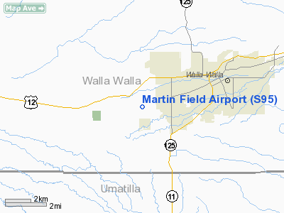
Martin Field (FAA LID: S95) is a privately-owned, public-use airport located one mile (2 km) west of the central business district of College Place, a city in Walla Walla County, Washington, United States. The airport was founded in the early 1940s by Herman L. Martin. During World War II, it served as a training ground for approximately 2500 United States Navy aviators.
Facilities and aircraft
Martin Field covers an area of 170 acres (69 ha) which contains one runway (5/23) with a 3,819 x 60 ft (1,164 x 18 m) asphalt pavement. For the 12-month period ending June 30, 2007, the airport had 5,000 general aviation aircraft operations, an average of 13 per day. At that time there were 53 aircraft based at this airport: 87% single-engine, 2% multi-engine and 11% ultralight.
The above content comes from Wikipedia and is published under free licenses – click here to read more.
Location & QuickFacts
| FAA Information Effective: | 2008-09-25 |
| Airport Identifier: | S95 |
| Airport Status: | Operational |
| Longitude/Latitude: | 118-25-01.8400W/46-02-48.9810N
-118.417178/46.046939 (Estimated) |
| Elevation: | 746 ft / 227.38 m (Estimated) |
| Land: | 170 acres |
| From nearest city: | 1 nautical miles W of College Place, WA |
| Location: | Walla Walla County, WA |
| Magnetic Variation: | 19E (1985) |
Owner & Manager
| Ownership: | Privately owned |
| Owner: | David Cheney |
| Address: | 214 Martin Field Lane
Walla Walla, WA 99362 |
| Phone number: | 509-522-1847 |
| Manager: | David Cheney |
| Address: | 214 Martin Field Lane
Walla Walla, WA 99362 |
| Phone number: | 509-522-1847 |
Airport Operations and Facilities
| Airport Use: | Open to public |
| Wind indicator: | Yes |
| Segmented Circle: | No |
| Control Tower: | No |
| Lighting Schedule: | RDO-CTL
ACTVT NSTD LIRL RY 05/23 AND VASI RYS 05 AND 23 - CTAF |
| Landing fee charge: | Yes |
| Sectional chart: | Seattle |
| Region: | ANM - Northwest Mountain |
| Boundary ARTCC: | ZSE - Seattle |
| Tie-in FSS: | SEA - Seattle |
| FSS on Airport: | No |
| FSS Toll Free: | 1-800-WX-BRIEF |
| NOTAMs Facility: | SEA (NOTAM-d service avaliable) |
Airport Communications
| CTAF: | 122.800 |
| Unicom: | 122.800 |
Airport Services
| Fuel available: | 100LL
24 HR SELF SERVICE CREDIT CARD FUELING FACILITY. |
| Airframe Repair: | MAJOR |
| Power Plant Repair: | MAJOR |
| Bottled Oxygen: | LOW |
Runway Information
Runway 05/23
| Dimension: | 3819 x 60 ft / 1164.0 x 18.3 m |
| Surface: | ASPH, Fair Condition |
| Weight Limit: | Single wheel: 12000 lbs. |
| Edge Lights: | Non-standard lighting system
RY 05/23 NSTD LIRL; SW 1240 FT MED INTST. |
| |
Runway 05 |
Runway 23 |
| Longitude: | 118-25-26.4200W | 118-24-37.2570W |
| Latitude: | 46-02-41.0840N | 46-02-56.8770N |
| Elevation: | 750.00 ft | 740.00 ft |
| Alignment: | 65 | 127 |
| Traffic Pattern: | Left | Left |
| Markings: | Basic, Fair Condition | Basic, Fair Condition |
| VASI: | 2-box on left side | 2-box on right side |
| Runway End Identifier: | No | No |
| Centerline Lights: | No | No |
| Touchdown Lights: | No | No |
| Obstruction: | , 50:1 slope to clear | 15 ft road, 200.0 ft from runway
ROAD 170', ROAD 50 R 0', FENCE & MAIL BOX +3 FT. |
|
Radio Navigation Aids
| ID |
Type |
Name |
Ch |
Freq |
Var |
Dist |
| PD | NDB | Foris | | 230.00 | 20E | 24.9 nm |
| LGD | NDB | La Grande | | 296.00 | 17E | 46.4 nm |
| ALW | VOR/DME | Walla Walla | 111X | 116.40 | 20E | 5.7 nm |
| PSC | VOR/DME | Pasco | 021X | 108.40 | 20E | 31.9 nm |
| PDT | VORTAC | Pendleton | 094X | 114.70 | 20E | 30.3 nm |
Remarks
- PRIVATE ROAD CROSSES 700' FROM SW END OF RW.
Images and information placed above are from
http://www.airport-data.com/airport/S95/
We thank them for the data!
| General Info
|
| Country |
United States
|
| State |
WASHINGTON
|
| FAA ID |
S95
|
| Latitude |
46-02-44.488N
|
| Longitude |
118-25-03.892W
|
| Elevation |
750 feet
|
| Near City |
COLLEGE PLACE
|
We don't guarantee the information is fresh and accurate. The data may
be wrong or outdated.
For more up-to-date information please refer to other sources.
|
|


