 |
|
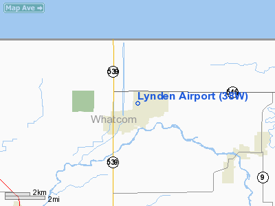
Location & QuickFacts
| FAA Information Effective: | 2008-09-25 |
| Airport Identifier: | 38W |
| Airport Status: | Operational |
| Longitude/Latitude: | 122-27-29.2260W/48-57-21.2260N
-122.458118/48.955896 (Estimated) |
| Elevation: | 106 ft / 32.31 m (Estimated) |
| Land: | 15 acres |
| From nearest city: | 1 nautical miles N of Lynden, WA |
| Location: | Whatcom County, WA |
| Magnetic Variation: | 21E (1985) |
Owner & Manager
| Ownership: | Publicly owned |
| Owner: | City Of Lynden |
| Address: | City Hall, 323 Front Street
Lynden, WA 98264 |
| Phone number: | 360-354-3446 |
| Manager: | Duane Huskey
ALTERNATE CONTACT: JOY FOX-PUBLIC WORKS ASSST |
| Address: | City Hall, 323 Front Street
Lynden, WA 98264
AIRPORT PHYSICAL ADDRESS: 8635 DEPOT ROAD, LYNDEN, WA 98264 |
| Phone number: | 360-354-3446 |
Airport Operations and Facilities
| Airport Use: | Open to public |
| Wind indicator: | Yes |
| Segmented Circle: | Yes |
| Control Tower: | No |
| Lighting Schedule: | RDO-CTL
ACTVT MIRL RY 07/25 & ROTATING BCN - 3 CLICKS CTAF. |
| Beacon Color: | Clear-Green (lighted land airport) |
| Landing fee charge: | No |
| Sectional chart: | Seattle |
| Region: | ANM - Northwest Mountain |
| Boundary ARTCC: | ZSE - Seattle |
| Responsible ARTCC: | ZVR - Vancouver |
| Tie-in FSS: | SEA - Seattle |
| FSS on Airport: | No |
| FSS Toll Free: | 1-800-WX-BRIEF |
| NOTAMs Facility: | SEA (NOTAM-d service avaliable) |
Airport Communications
Airport Services
| Fuel available: | 100LL
AUTOMATED CREDIT CARD SYSTEM FOR FUEL. |
| Bottled Oxygen: | NONE |
| Bulk Oxygen: | NONE |
Runway Information
Runway 07/25
| Dimension: | 2425 x 40 ft / 739.1 x 12.2 m |
| Surface: | ASPH, Good Condition |
| Weight Limit: | Single wheel: 12000 lbs. |
| Edge Lights: | Non-standard lighting system
NO WHITE/RED LIGHTS PAST DISPLACED THRESHOLD. |
| |
Runway 07 |
Runway 25 |
| Longitude: | 122-27-47.3820W | 122-27-11.0700W |
| Latitude: | 48-57-21.6590N | 48-57-20.7920N |
| Traffic Pattern: | Left | Left |
| Markings: | Basic, Fair Condition | Basic, Fair Condition |
| Crossing Height: | 15.00 ft | 15.00 ft |
| Displaced threshold: | 262.00 ft | 433.00 ft |
| VASI: | 2-light PAPI on left side | 2-light PAPI on right side |
| Visual Glide Angle: | 3.00° | 6.00° |
| Obstruction: | 5 ft fence, 292.0 ft from runway, 62 ft left of centerline, 18:1 slope to clear
RWY 07 APCH SLOPE 16:1 TO +17 FT ROAD AT 272 FT FROM DSPLCD THR.
ROAD AT 10', 75' TREES 50' RIGHT AT 0', 20' TREES 20L AT 0'. | 16 ft road, 202.0 ft from runway
RWY 25 APCH SLOPE 39:1 TO DSPLCD THLD; +70 FT TREES 1050 FT 0B.
ROAD AT 50 FT TREES AT 200 FT +50 FT R AT 20 FT FM THLD; 80 FT TREES AT 0 FT 80 FT L; +7 FT BUSHES AT 0 FT LT. |
|
Radio Navigation Aids
| ID |
Type |
Name |
Ch |
Freq |
Var |
Dist |
| XX | NDB | Abbotsford | | 344.00 | 21E | 3.8 nm |
| WC | NDB | White Rock | | 332.00 | 21E | 11.2 nm |
| LU | NDB | Cultus | | 214.00 | 22E | 16.6 nm |
| VR | NDB | Vancouver | | 266.00 | 21E | 27.0 nm |
| BVS | NDB | Skagit/bay View | | 240.00 | 21E | 29.3 nm |
| V | NDB | Victor | | 368.00 | 22E | 33.2 nm |
| AP | NDB | Active Pass | | 378.00 | 21E | 33.2 nm |
| OPZ | NDB | Lopez Island | | 356.00 | 21E | 34.0 nm |
| FHR | NDB | Friday Harbor | | 284.00 | 20E | 34.3 nm |
| YJ | NDB | Victoria | | 200.00 | 21E | 41.7 nm |
| MB | NDB | Mill Bay | | 293.00 | 21E | 46.0 nm |
| HE | NDB | Hope | | 245.00 | 21E | 48.2 nm |
| NUW | TACAN | Whidbey Island | 085X | | 21E | 37.0 nm |
| YYJ | VOR/DME | Victoria | 084X | 113.70 | 21E | 42.9 nm |
| CVV | VOR/DME | Penn Cove | 119X | 117.20 | 19E | 44.0 nm |
| HUH | VORTAC | Whatcom | 077X | 113.00 | 20E | 4.8 nm |
| YVR | VORTAC | Vancouver | 44 | 115.90 | 21E | 28.2 nm |
Remarks
- REPORT ON DOWNWIND ON 122.9
- 1850' BTWN THR LGTS; RY 07 THR LGTS LOCATED 134' PRIOR TO DSPLCD THR.
- NIGHT LDNGS SHOULD BE PERFORMED ON RY 07 - WINDS PERMITTING.
- THR RELCTD 155 FT FOR NIGHT OPNS; RY 25 THR RELCTD 434 FT FOR NIGHT OPNS; 1871 FT LGTD AT NIGHT.
- ESTABD PRIOR TO 15 MAY 1959.
Images and information placed above are from
http://www.airport-data.com/airport/38W/
We thank them for the data!
| General Info
|
| Country |
United States
|
| State |
WASHINGTON
|
| FAA ID |
38W
|
| Latitude |
48-57-21.416N
|
| Longitude |
122-27-27.586W
|
| Elevation |
105 feet
|
| Near City |
LYNDEN
|
We don't guarantee the information is fresh and accurate. The data may
be wrong or outdated.
For more up-to-date information please refer to other sources.
|
|


