 |
|
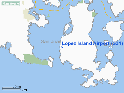
| Lopez Island Airport |
| IATA: none – ICAO: none – FAA LID: S31 |
| Summary |
| Airport type |
Public |
| Owner |
Port of Lopez |
| Location |
Lopez Island, Washington |
| Elevation AMSL |
209 ft / 64 m |
| Coordinates |
48°29′02″N 122°56′16″W / 48.48389°N 122.93778°W / 48.48389; -122.93778 |
| Runways |
| Direction |
Length |
Surface |
| ft |
m |
| 16/34 |
2,904 |
885 |
Asphalt |
| Statistics (2002) |
| Aircraft operations |
31,000 |
| Based aircraft |
34 |
| Source: Federal Aviation Administration |
Lopez Island Airport (FAA LID: S31) is a public use airport located three nautical miles (6 km) south of the central business district of Lopez, a village on Lopez Island in San Juan County, Washington, United States. It is owned by the Port of Lopez. Facilities and aircraft
Lopez Island Airport covers an area of 50 acres (20 ha) at an elevation of 209 feet (64 m) above mean sea level. It has one runway designated 16/34 with an asphalt surface measuring 2,904 by 60 feet (885 x 18 m).
For the 12-month period ending May 31, 2007, the airport had 31,500 aircraft operations, an average of 86 per day: 75% general aviation and 25% air taxi. At that time there were 34 aircraft based at this airport: 94% single-engine, 3% multi-engine and 3% helicopter.
Airlines and destinations
| Airlines |
Destinations |
| San Juan Airlines |
Anacortes, Bellingham |
The above content comes from Wikipedia and is published under free licenses – click here to read more.
Location & QuickFacts
| FAA Information Effective: | 2008-09-25 |
| Airport Identifier: | S31 |
| Airport Status: | Operational |
| Longitude/Latitude: | 122-56-15.6530W/48-29-02.0850N
-122.937681/48.483912 (Estimated) |
| Elevation: | 209 ft / 63.70 m (Estimated) |
| Land: | 50 acres |
| From nearest city: | 3 nautical miles S of Lopez, WA |
| Location: | San Juan County, WA |
| Magnetic Variation: | 21E (1985) |
Owner & Manager
| Ownership: | Publicly owned |
| Owner: | Port Of Lopez |
| Address: | Po Box 907
Lopez, WA 98261 |
| Phone number: | 360-468-4116 |
| Manager: | Helen Cosgrove |
| Address: | Po Box 907
Lopez, WA 98261 |
| Phone number: | 360-468-4116 |
Airport Operations and Facilities
| Airport Use: | Open to public |
| Wind indicator: | Yes |
| Segmented Circle: | Yes |
| Control Tower: | No |
| Lighting Schedule: | DUSK-DAWN |
| Beacon Color: | Clear-Green (lighted land airport) |
| Landing fee charge: | No |
| Sectional chart: | Seattle |
| Region: | ANM - Northwest Mountain |
| Boundary ARTCC: | ZSE - Seattle |
| Tie-in FSS: | SEA - Seattle |
| FSS on Airport: | No |
| FSS Toll Free: | 1-800-WX-BRIEF |
| NOTAMs Facility: | SEA (NOTAM-d service avaliable) |
| Federal Agreements: | NGY |
Airport Communications
Airport Services
| Airframe Repair: | NONE |
| Power Plant Repair: | NONE |
| Bottled Oxygen: | NONE |
| Bulk Oxygen: | NONE |
Runway Information
Runway 16/34
| Dimension: | 2904 x 60 ft / 885.1 x 18.3 m |
| Surface: | ASPH, Good Condition |
| Weight Limit: | Single wheel: 12500 lbs. |
| Edge Lights: | Low
TWY MARKED WITH REFLECTORS. |
| |
Runway 16 |
Runway 34 |
| Longitude: | 122-56-15.7260W | 122-56-15.5800W |
| Latitude: | 48-29-16.4170N | 48-28-47.7530N |
| Elevation: | 209.00 ft | 163.00 ft |
| Traffic Pattern: | Right | Left |
| Markings: | Basic, Good Condition | Basic, Good Condition |
| Crossing Height: | 40.00 ft | 32.00 ft |
| VASI: | 2-light PAPI on left side | 2-light PAPI on left side |
| Visual Glide Angle: | 4.00° | 4.00° |
| Runway End Identifier: | | Yes |
| Obstruction: | 67 ft trees, 502.0 ft from runway, 186 ft left of centerline, 5:1 slope to clear | 58 ft trees, 752.0 ft from runway, 168 ft left of centerline, 9:1 slope to clear |
|
Radio Navigation Aids
| ID |
Type |
Name |
Ch |
Freq |
Var |
Dist |
| OPZ | NDB | Lopez Island | | 356.00 | 21E | 0.7 nm |
| FHR | NDB | Friday Harbor | | 284.00 | 20E | 4.4 nm |
| BVS | NDB | Skagit/bay View | | 240.00 | 21E | 20.7 nm |
| YJ | NDB | Victoria | | 200.00 | 21E | 20.7 nm |
| MB | NDB | Mill Bay | | 293.00 | 21E | 26.3 nm |
| AP | NDB | Active Pass | | 378.00 | 21E | 27.3 nm |
| WC | NDB | White Rock | | 332.00 | 21E | 32.2 nm |
| CL | NDB | Elwha | | 515.00 | 22E | 35.5 nm |
| XX | NDB | Abbotsford | | 344.00 | 21E | 36.6 nm |
| VR | NDB | Vancouver | | 266.00 | 21E | 41.7 nm |
| V | NDB | Victor | | 368.00 | 22E | 44.0 nm |
| LU | NDB | Cultus | | 214.00 | 22E | 47.8 nm |
| NUW | TACAN | Whidbey Island | 085X | | 21E | 13.5 nm |
| CVV | VOR/DME | Penn Cove | 119X | 117.20 | 19E | 16.7 nm |
| YYJ | VOR/DME | Victoria | 084X | 113.70 | 21E | 26.2 nm |
| PAE | VOR/DME | Paine | 043X | 110.60 | 20E | 43.0 nm |
| HUH | VORTAC | Whatcom | 077X | 113.00 | 20E | 31.2 nm |
| YVR | VORTAC | Vancouver | 44 | 115.90 | 21E | 36.6 nm |
Remarks
- RY 16/34 SOFT SHOULDERS & THLDS.
- ESTABD PRIOR TO 1959.
Images and information placed above are from
http://www.airport-data.com/airport/S31/
We thank them for the data!
| General Info
|
| Country |
United States
|
| State |
WASHINGTON
|
| FAA ID |
S31
|
| Latitude |
48-28-57.358N
|
| Longitude |
122-56-12.640W
|
| Elevation |
200 feet
|
| Near City |
LOPEZ
|
We don't guarantee the information is fresh and accurate. The data may
be wrong or outdated.
For more up-to-date information please refer to other sources.
|
|


