 |
|
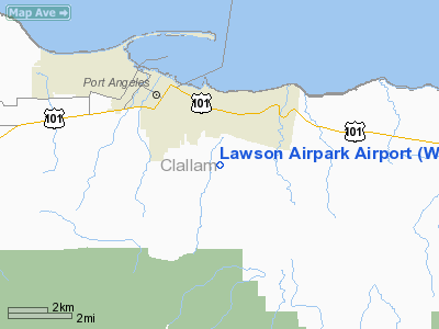
Location & QuickFacts
| FAA Information Effective: | 2008-09-25 |
| Airport Identifier: | WN21 |
| Airport Status: | Operational |
| Longitude/Latitude: | 123-23-52.6660W/48-04-53.3260N
-123.397963/48.081479 (Estimated) |
| Elevation: | 650 ft / 198.12 m (Estimated) |
| Land: | 64 acres |
| From nearest city: | 3 nautical miles SE of Port Angeles, WA |
| Location: | Clallam County, WA |
| Magnetic Variation: | 21E (1985) |
Owner & Manager
| Ownership: | Privately owned |
| Owner: | Dan Lawson |
| Address: | 822 Monroe Rd.
Port Angeles, WA 98362 |
| Phone number: | 206-452-9575 |
| Manager: | Dan Lawson |
| Address: | 822 Monroe Rd.
Port Angeles, WA 98362 |
| Phone number: | 206-452-9575 |
Airport Operations and Facilities
| Airport Use: | Private |
| Wind indicator: | Yes |
| Segmented Circle: | No |
| Control Tower: | No |
| Sectional chart: | Seattle |
| Region: | ANM - Northwest Mountain |
| Boundary ARTCC: | ZSE - Seattle |
| Tie-in FSS: | SEA - Seattle |
| FSS on Airport: | No |
| FSS Toll Free: | 1-800-WX-BRIEF |
Runway Information
Runway 04/22
| Dimension: | 2400 x 70 ft / 731.5 x 21.3 m |
| Surface: | TURF, |
| |
Runway 04 |
Runway 22 |
| Traffic Pattern: | Left | Left |
| Displaced threshold: | 300.00 ft | 0.00 ft |
|
Radio Navigation Aids
| ID |
Type |
Name |
Ch |
Freq |
Var |
Dist |
| CL | NDB | Elwha | | 515.00 | 22E | 11.7 nm |
| FHR | NDB | Friday Harbor | | 284.00 | 20E | 30.6 nm |
| OPZ | NDB | Lopez Island | | 356.00 | 21E | 30.6 nm |
| YJ | NDB | Victoria | | 200.00 | 21E | 33.8 nm |
| MB | NDB | Mill Bay | | 293.00 | 21E | 35.9 nm |
| PWT | NDB | Kitsap | | 206.00 | 20E | 43.9 nm |
| BVS | NDB | Skagit/bay View | | 240.00 | 21E | 45.6 nm |
| CAN | NDB | Carney | | 274.00 | 20E | 46.2 nm |
| AP | NDB | Active Pass | | 378.00 | 21E | 47.8 nm |
| NUW | TACAN | Whidbey Island | 085X | | 21E | 33.8 nm |
| CVV | VOR/DME | Penn Cove | 119X | 117.20 | 19E | 28.7 nm |
| YYJ | VOR/DME | Victoria | 084X | 113.70 | 21E | 39.0 nm |
| PAE | VOR/DME | Paine | 043X | 110.60 | 20E | 46.1 nm |
Remarks
Images and information placed above are from
http://www.airport-data.com/airport/WN21/
We thank them for the data!
| General Info
|
| Country |
United States
|
| State |
WASHINGTON
|
| FAA ID |
WN21
|
| Latitude |
48-04-53.326N
|
| Longitude |
123-23-52.666W
|
| Elevation |
650 feet
|
| Near City |
PORT ANGELES
|
We don't guarantee the information is fresh and accurate. The data may
be wrong or outdated.
For more up-to-date information please refer to other sources.
|
|


