 |
|
Lake Wenatchee State Airport |
| Lake Wenatchee State Airport |
| IATA: none – ICAO: none – FAA LID: 27W |
| Summary |
| Airport type |
Public |
| Owner |
WSDOT Aviation Division |
| Serves |
Leavenworth, Washington |
| Elevation AMSL |
1,939 ft / 591 m |
| Coordinates |
47°49′10″N 120°43′12″W / 47.81944°N 120.72°W / 47.81944; -120.72 |
| Runways |
| Direction |
Length |
Surface |
| ft |
m |
| 9/27 |
2,473 |
754 |
Turf |
| Statistics (2007) |
| Aircraft operations |
600 |
| Source: Federal Aviation Administration |
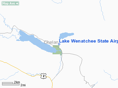
Lake Wenatchee State Airport (FAA LID: 27W) is a public use airport located 14 nautical miles (26 km) northwest of the central business district of Leavenworth, a city in Chelan County, Washington, United States. It is owned by the Washington State DOT Aviation Division.
The airport is located next to Lake Wenatchee State Park with 197 well prepared campsites. Outdoor toilets and space for camping are also available on the airport. Fishing, water recreation, and hiking are available at the nearby lakes.
Facilities and aircraft
Lake Wenatchee State Airport covers an area of 35 acres (14 ha). The 2,473-foot (754 m) turf runway has a 100-foot (30 m) wide center strip outlined with reflectors. Field elevation is 1,939 feet (591 m) above mean sea level and some density altitude problems can be anticipated on hot summer days.
The runway surface is somewhat rough and animals are very common. A local winter recreation club does much of the maintenance, and work crews and equipment are common. Trees surround the airport, and there are trees in both approaches close in. The airport is generally open from June 1 to October 1.
For the 12-month period ending July 31, 2007, the airport had 600 general aviation aircraft operations, an average of 50 per month.
The above content comes from Wikipedia and is published under free licenses – click here to read more.
Location & QuickFacts
| FAA Information Effective: | 2008-09-25 |
| Airport Identifier: | 27W |
| Airport Status: | Operational |
| Longitude/Latitude: | 120-43-11.6190W/47-49-09.8890N
-120.719894/47.819414 (Estimated) |
| Elevation: | 1939 ft / 591.01 m (Estimated) |
| Land: | 35 acres |
| From nearest city: | 14 nautical miles NW of Leavenworth, WA |
| Location: | Chelan County, WA |
| Magnetic Variation: | 20E (1985) |
Owner & Manager
| Ownership: | Publicly owned |
| Owner: | Wsdot Aviation Division |
| Address: | 3704 172nd Street Ne, Suite K2, P.o. Box 3367
Arlington, WA 98223-6336 |
| Phone number: | 360-651-6300 |
| Manager: | Wsdot Aviation Division |
| Address: | 3704 172nd Street Ne, Suite K2, P.o. Box 3367
Arlington, WA 98223-6336 |
| Phone number: | 360-651-6300 |
Airport Operations and Facilities
| Airport Use: | Open to public |
| Wind indicator: | Yes |
| Segmented Circle: | No |
| Control Tower: | No |
| Landing fee charge: | No |
| Sectional chart: | Seattle |
| Region: | ANM - Northwest Mountain |
| Boundary ARTCC: | ZSE - Seattle |
| Tie-in FSS: | SEA - Seattle |
| FSS on Airport: | No |
| FSS Toll Free: | 1-800-WX-BRIEF |
| NOTAMs Facility: | SEA (NOTAM-d service avaliable) |
| Federal Agreements: | S1 |
Airport Communications
Airport Services
| Airframe Repair: | NONE |
| Power Plant Repair: | NONE |
| Bottled Oxygen: | NONE |
| Bulk Oxygen: | NONE |
Runway Information
Runway 09/27
| Dimension: | 2473 x 100 ft / 753.8 x 30.5 m |
| Surface: | TURF, Fair Condition |
| |
Runway 09 |
Runway 27 |
| Longitude: | 120-43-28.7070W | 120-42-54.5310W |
| Latitude: | 47-49-13.9500N | 47-49-05.8280N |
| Elevation: | 1936.00 ft | 0.00 ft |
| Alignment: | 109 | 127 |
| Traffic Pattern: | Left | Left |
| Obstruction: | 15 ft road, 105 ft left of centerline | 15 ft road, 0.0 ft from runway, 104 ft right of centerline |
|
Radio Navigation Aids
| ID |
Type |
Name |
Ch |
Freq |
Var |
Dist |
| EAT | FAN MARKER | Malaga | | | 21E | 36.3 nm |
| EAT | VOR/DME | Wenatchee | 047X | 111.00 | 19E | 32.6 nm |
| ELN | VORTAC | Ellensburg | 126X | 117.90 | 21E | 49.0 nm |
Remarks
- ARPT CLSD YEARLY 1 OCT-1 JUN.
- DENSITY ALTITUDE.
- PEDESTRIANS; VEHICLES & ANIMALS INVOF RY.
- CTC WASHINGTON STATE AVIATION DIVISION 360-651-6300 OR 800-552-0666 FOR FACILITY INFO PRIOR TO USE.
- ESTBD PRIOR TO MAY 1959.
Images and information placed above are from
http://www.airport-data.com/airport/27W/
We thank them for the data!
| General Info
|
| Country |
United States
|
| State |
WASHINGTON
|
| FAA ID |
27W
|
| Latitude |
47-49-09.439N
|
| Longitude |
120-43-11.340W
|
| Elevation |
1936 feet
|
| Near City |
LEAVENWORTH
|
We don't guarantee the information is fresh and accurate. The data may
be wrong or outdated.
For more up-to-date information please refer to other sources.
|
|


