 |
|
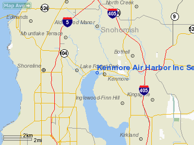
Kenmore Air Harbor Inc Seaplane Base Airport |
| Kenmore Air Harbor Inc. Seaplane Base |
| IATA: KEH – ICAO: none – FAA LID: S60 |
| Summary |
| Airport type |
Public |
| Owner |
Gregg Munro |
| Serves |
Kenmore, Washington |
| Location |
Lake Washington |
| Elevation AMSL |
14 ft / 4 m |
| Coordinates |
47°45′17″N 122°15′33″W / 47.75472°N 122.25917°W / 47.75472; -122.25917 |
| Website |
www.KenmoreAir.com |
| Runways |
| Direction |
Length |
Surface |
| ft |
m |
| 16/34 |
10,000 |
3,048 |
Water |
| 18/36 |
3,000 |
914 |
Water |
| Statistics (2007) |
| Aircraft operations |
48,300 |
| Based aircraft |
60 |
| Source: FAA, WSDOT |
Kenmore Air Harbor or Kenmore Air Harbor Inc. Seaplane Base (IATA: KEH, FAA LID: S60) is a public-use seaplane base located one nautical mile (1.85 km) south of the central business district of Kenmore, a city in King County, Washington, United States. It is situated on the northern end of Lake Washington. History
Kenmore Air was founded in 1946 by three high school friends, reunited after World War II. With one airplane, and a single hangar near a swamp at the North end of Lake Washington (Seattle), Bob Munro, Reg Collins, and Jack Mines gave birth to what was to become the largest and most respected seaplane airline in the world. In 2003 Kenmore Air started an all weather wheel plane passenger and cargo service (Kenmore Air Express) based out of the Boeing Field airport. This new services adds reliable all weather day/night flights to several Puget Sound destinations and also Campbell River BC.
Facilities and aircraft
Kenmore Air Harbor Inc. Seaplane Base covers an area of 5 acres (2 ha) at an elevation of 14 feet (4 m) above mean sea level. It has two seaplane landing areas: 16/34 is 10,000 by 1,000 feet (3,048 x 305 m) and 18/36 is 3,000 by 1,000 feet (914 x 305 m).
For the 12-month period ending December 31, 2007, the airport had 48,300 aircraft operations, an average of 132 per day: 83% air taxi and 17% general aviation. At that time there were 60 single-engine aircraft based at this airport.
Airlines and destinations
| Airlines |
Destinations |
| Kenmore Air |
Lopez Island, Orcas Island, San Juan Island, Victoria, Saanich Peninsula, Nanaimo, Campbell River, Big Bay Area, Sunshine Coast and NE Vancouver Island |
Media appearances
Kenmore Air Harbor is the base for the "San Juan Island Run" mission supplied with Microsoft Flight Simulator X.
The above content comes from Wikipedia and is published under free licenses – click here to read more.
Location & QuickFacts
| FAA Information Effective: | 2008-09-25 |
| Airport Identifier: | S60 |
| Airport Status: | Operational |
| Longitude/Latitude: | 122-15-33.4550W/47-45-17.3520N
-122.259293/47.754820 (Estimated) |
| Elevation: | 14 ft / 4.27 m (Estimated) |
| Land: | 5 acres |
| From nearest city: | 1 nautical miles S of Kenmore, WA |
| Location: | King County, WA |
| Magnetic Variation: | 20E (1985) |
Owner & Manager
| Ownership: | Privately owned |
| Owner: | Gregg Munro |
| Address: | Po Box 82064
Kenmore, WA 98028-0064 |
| Phone number: | 425-486-1257 |
| Manager: | Todd Banks |
| Address: | Po Box 82064
Kenmore, WA 98028-0064 |
| Phone number: | 425-486-1257
EXT. 2220 |
Airport Operations and Facilities
| Airport Use: | Open to public |
| Wind indicator: | Yes |
| Segmented Circle: | No |
| Control Tower: | No |
| Landing fee charge: | No |
| Sectional chart: | Seattle |
| Region: | ANM - Northwest Mountain |
| Boundary ARTCC: | ZSE - Seattle |
| Tie-in FSS: | SEA - Seattle |
| FSS on Airport: | No |
| FSS Toll Free: | 1-800-WX-BRIEF |
| NOTAMs Facility: | SEA (NOTAM-d service avaliable) |
| Federal Agreements: | N |
Airport Communications
| CTAF: | 122.700 |
| Unicom: | 122.700 |
Airport Services
| Fuel available: | 100LLA |
| Airframe Repair: | MAJOR |
| Power Plant Repair: | MAJOR |
| Bottled Oxygen: | NONE |
| Bulk Oxygen: | NONE |
Runway Information
Runway 16/34
| Dimension: | 10000 x 1000 ft / 3048.0 x 304.8 m |
| Surface: | WATER, |
| |
Runway 16 |
Runway 34 |
| Elevation: | 14.00 ft | 14.00 ft |
| Traffic Pattern: | Left | Left |
|
Runway 18/36
| Dimension: | 3000 x 1000 ft / 914.4 x 304.8 m |
| Surface: | WATER, |
| |
Runway 18 |
Runway 36 |
| Elevation: | 14.00 ft | 14.00 ft |
| Traffic Pattern: | Left | Left |
|
Radio Navigation Aids
| ID |
Type |
Name |
Ch |
Freq |
Var |
Dist |
| RNT | NDB | Renton | | 353.00 | 20E | 15.7 nm |
| ODD | NDB | Dondo | | 224.00 | 19E | 23.6 nm |
| PWT | NDB | Kitsap | | 206.00 | 20E | 25.6 nm |
| CAN | NDB | Carney | | 274.00 | 20E | 31.3 nm |
| GR | NDB | Graye | | 216.00 | 18E | 39.0 nm |
| BVS | NDB | Skagit/bay View | | 240.00 | 21E | 43.4 nm |
| MNC | NDB | Mason County | | 348.00 | 19E | 45.3 nm |
| LAC | NDB | Lacomas | | 328.00 | 18E | 46.5 nm |
| NUW | TACAN | Whidbey Island | 085X | | 21E | 39.5 nm |
| PAE | VOR/DME | Paine | 043X | 110.60 | 20E | 9.9 nm |
| CVV | VOR/DME | Penn Cove | 119X | 117.20 | 19E | 34.9 nm |
| SEA | VORTAC | Seattle | 115X | 116.80 | 19E | 19.3 nm |
| TCM | VORTAC | Mcchord | 033X | 109.60 | 22E | 37.5 nm |
| BFI | VOT | Boeing Field | | 108.60 | | 13.8 nm |
| SEA | VOT | Seattle-tacoma | | 117.50 | | 18.8 nm |
Remarks
- APCH SURFACE DATA NOT CHECKED.
- LOADING EQUIP & 100' CRANES PKD ADJ TO FBO AREA CERTAIN PERIODS OF THE YEAR.
- 8 BUOYS MARK 5 MPH SPEED LIMIT AREA WI LANDING ZONE - UNLGTD; SEAPLANES EXEMPT FM 5 MPH SPEED LIMIT.
- UNLGTD CRANE 75' AGL & PILINGS 6' ABOVE WATER RWY 18.
- 2 +6 FT NAVIGATIONAL BUOYS MKG S SIDE OF COMMERCIAL WATERLANE; LGTD WITH BLINKING DIM RED LGTS; BLINK AT APROX 2 SECOND INTVL; EXTREMELY DIFFICULT TO SEE.
- SFC WATERCRAFT ENTERING OPERATING AREA FM CHANNEL E OF RY 16/34.
- ESTABD PRIOR TO 15 MAY 1959.
Images and information placed above are from
http://www.airport-data.com/airport/S60/
We thank them for the data!
| General Info
|
| Country |
United States
|
| State |
WASHINGTON
|
| FAA ID |
S60
|
| Latitude |
47-45-17.352N
|
| Longitude |
122-15-33.455W
|
| Elevation |
14 feet
|
| Near City |
KENMORE
|
We don't guarantee the information is fresh and accurate. The data may
be wrong or outdated.
For more up-to-date information please refer to other sources.
|
|


