 |
|
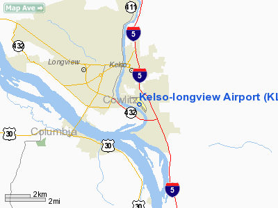
| Southwest Washington Regional Airport |
| IATA: KLS – ICAO: KKLS – FAA LID: KLS |
| Summary |
| Airport type |
Public |
| Owner |
City of Kelso |
| Serves |
Longview-Kelso Metropolitan Area |
| Elevation AMSL |
20 ft / 6 m |
| Coordinates |
46°07′05″N 122°53′54″W / 46.11806°N 122.89833°W / 46.11806; -122.89833 |
| Website |
Official site |
| Runways |
| Direction |
Length |
Surface |
| ft |
m |
| 12/30 |
4,391 |
1,338 |
Asphalt |
| Statistics (2008) |
| Aircraft operations |
40,860 |
| Based aircraft |
71 |
| Source: Federal Aviation Administration |
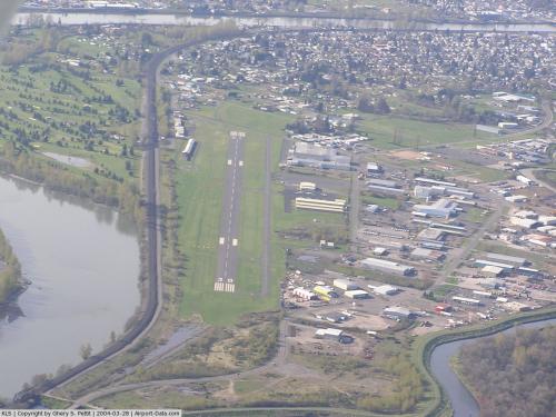
Southwest Washington Regional Airport (IATA: KLS, ICAO: KKLS, FAA LID: KLS) is a city-owned public-use airport located two nautical miles (3.7 km) southeast of the central business district of Kelso, in Cowlitz County, Washington, United States. The airport was renamed in 2009, prior to which it was known as Kelso-Longview Regional Airport or Molt Taylor Field. History
Kelso-Longview Airport opened in May 1941 on 109 acres of a nearby dairy farm, as a training field for amateur pilots, and has since become a regional transportation center for southwest Washington. In 1950 the old landing strip was paved, and in the 1960s the first administration and terminal buildings were built.
Facilities and aircraft
Southwest Washington Regional Airport covers an area of 110 acres (45 ha) at an elevation of 20 feet (6 m) above mean sea level. It has one asphalt paved runway designated 12/30 which measure 4,391 x 100 ft. (1,338 x 30 m). It is separated for takeoffs and landings (the airport, faced with growing air traffic, segmented their runway in 1980).
For the 12-month period ending March 30, 2008, the airport had 40,860 aircraft operations, an average of 111 per day: 94% general aviation, 4% air taxi and 2% military. At that time there were 71 aircraft based at this airport: 85% single-engine, 10% multi-engine, 1% jet and 4% ultralight.
The airport has one passenger terminal consisting of 12 gates. Gates 1-4 are for large jet aircraft and the other gates are for private planes or medium-sized jets.
The above content comes from Wikipedia and is published under free licenses – click here to read more.
 |
(Click on the photo to enlarge) |
Location & QuickFacts
| FAA Information Effective: | 2008-09-25 |
| Airport Identifier: | KLS |
| Airport Status: | Operational |
| Longitude/Latitude: | 122-53-54.2000W/46-07-04.8000N
-122.898389/46.118000 (Estimated) |
| Elevation: | 20 ft / 6.10 m (Surveyed) |
| Land: | 110 acres |
| From nearest city: | 2 nautical miles SE of Kelso, WA |
| Location: | Cowlitz County, WA |
| Magnetic Variation: | 20E (1985) |
Owner & Manager
| Ownership: | Publicly owned |
| Owner: | City Of Kelso |
| Address: | 203 S. Pacific Ave Suite 205
Kelso, WA 98626 |
| Phone number: | 360-423-6590 |
| Manager: | Dennis Wise |
| Address: | 2215 Parrott Way # A
Kelso, WA 98626 |
| Phone number: | 360-414-4333 |
Airport Operations and Facilities
| Airport Use: | Open to public |
| Wind indicator: | Yes |
| Segmented Circle: | Yes |
| Control Tower: | No |
| Lighting Schedule: | DUSK-DAWN
ACTVT MIRL RY 12/30 - CTAF. |
| Beacon Color: | Clear-Green (lighted land airport) |
| Landing fee charge: | No |
| Sectional chart: | Seattle |
| Region: | ANM - Northwest Mountain |
| Boundary ARTCC: | ZSE - Seattle |
| Tie-in FSS: | SEA - Seattle |
| FSS on Airport: | No |
| FSS Toll Free: | 1-800-WX-BRIEF |
| NOTAMs Facility: | KLS (NOTAM-d service avaliable) |
| Federal Agreements: | NGY |
Airport Communications
| CTAF: | 122.800 |
| Unicom: | 122.800 |
Airport Services
| Fuel available: | 100LLA
24 HR SELF SVC CREDIT CARD FUEL FAC. |
| Airframe Repair: | MAJOR |
| Power Plant Repair: | MAJOR |
| Bottled Oxygen: | NONE |
| Bulk Oxygen: | NONE |
Runway Information
Runway 12/30
| Dimension: | 4391 x 100 ft / 1338.4 x 30.5 m |
| Surface: | ASPH, Good Condition |
| Weight Limit: | Single wheel: 38000 lbs.
Dual wheel: 46000 lbs.
Dual tandem wheel: 74000 lbs. |
| Edge Lights: | Non-standard lighting system
RWY 12/30 NSTD SPACING MIRL |
| |
Runway 12 |
Runway 30 |
| Longitude: | 122-54-14.0329W | 122-53-34.2605W |
| Latitude: | 46-07-21.5239N | 46-06-48.1481N |
| Elevation: | 20.00 ft | 16.00 ft |
| Alignment: | 127 | 127 |
| Traffic Pattern: | Right | Left |
| Markings: | Non-precision instrument, Fair Condition | Non-precision instrument, Fair Condition |
| Crossing Height: | 37.00 ft | 40.00 ft |
| VASI: | 4-light PAPI on left side | 4-light PAPI on right side |
| Visual Glide Angle: | 4.00° | 4.00° |
| Runway End Identifier: | Yes | Yes |
| Obstruction: | 38 ft trees, 1201.0 ft from runway, 109 ft left of centerline, 26:1 slope to clear | 25 ft trees, 738.0 ft from runway, 160 ft left of centerline, 21:1 slope to clear
+3' HILL FROM 40' TO 200'; 105L. |
|
Radio Navigation Aids
| ID |
Type |
Name |
Ch |
Freq |
Var |
Dist |
| AST | FAN MARKER | Fort Stevens | | | 22E | 44.8 nm |
| LSO | NDB | Kelso | | 256.00 | 21E | 2.3 nm |
| TDO | NDB | Toledo | | 219.00 | 20E | 21.8 nm |
| PEN | NDB | Karpen | | 201.00 | 20E | 28.7 nm |
| PND | NDB | Banks | | 356.00 | 21E | 30.0 nm |
| LBH | NDB | Laker | | 332.00 | 20E | 39.2 nm |
| CBU | TACAN | Columbia | 029X | | 20E | 34.0 nm |
| PDX | VOR/DME | Portland | 055X | 111.80 | 20E | 33.8 nm |
| AST | VOR/DME | Astoria | 087X | 114.00 | 19E | 41.0 nm |
| UBG | VOR/DME | Newberg | 121X | 117.40 | 21E | 46.1 nm |
| BTG | VORTAC | Battle Ground | 113X | 116.60 | 21E | 25.7 nm |
| PDX | VOT | Portland Intl | | 111.00 | | 33.6 nm |
| HIO | VOT | Portland-hillsboro | | 115.20 | | 34.8 nm |
Remarks
- NMRS FLOCKS OF BIRDS ON & INVOF ARPT.
- ESTABD PRIOR TO 15 MAY 1959.
Images and information placed above are from
http://www.airport-data.com/airport/KLS/
We thank them for the data!
| General Info
|
| Country |
United States
|
| State |
WASHINGTON
|
| FAA ID |
KLS
|
| Latitude |
46-07-04.800N
|
| Longitude |
122-53-54.200W
|
| Elevation |
20 feet
|
| Near City |
KELSO
|
We don't guarantee the information is fresh and accurate. The data may
be wrong or outdated.
For more up-to-date information please refer to other sources.
|
|


