 |
|
Hoskins Field is a baseball park located in Wichita Falls, Texas and was the home of the TCL Wichita Falls Roughnecks for the 2007 season. Before they moved to Wichita Falls, they were called the Graham Roughnecks and belonged to Graham, Texas.
The above content comes from Wikipedia and is published under free licenses – click here to read more.
Location & QuickFacts
| FAA Information Effective: | 2008-09-25 |
| Airport Identifier: | 44T |
| Airport Status: | Operational |
| Longitude/Latitude: | 122-49-39.4880W/46-59-33.3470N
-122.827636/46.992596 (Estimated) |
| Elevation: | 213 ft / 64.92 m (Estimated) |
| Land: | 5 acres |
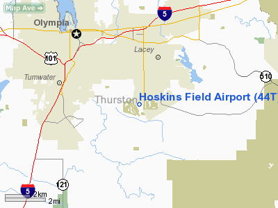
| From nearest city: | 5 nautical miles SE of Olympia, WA |
| Location: | Thurston County, WA |
| Magnetic Variation: | 20E (1985) |
Owner & Manager
| Ownership: | Privately owned |
| Owner: | Chambers Estate Association |
| Address: | 4418 62nd Avenue Se
Olympia, WA 98513-4906 |
| Phone number: | 360-491-6723 |
| Manager: | John Mc Clain |
| Address: | 4418 62nd Avenue Se
Olympia, WA 98513-4906 |
| Phone number: | 360-491-6723 |
Airport Operations and Facilities
| Airport Use: | Open to public |
| Wind indicator: | Yes |
| Segmented Circle: | No |
| Control Tower: | No |
| Landing fee charge: | No |
| Sectional chart: | Seattle |
| Region: | ANM - Northwest Mountain |
| Boundary ARTCC: | ZSE - Seattle |
| Tie-in FSS: | SEA - Seattle |
| FSS on Airport: | No |
| FSS Toll Free: | 1-800-WX-BRIEF |
| NOTAMs Facility: | SEA (NOTAM-d service avaliable) |
Airport Communications
Airport Services
| Airframe Repair: | NONE |
| Power Plant Repair: | NONE |
Runway Information
Runway 07/25
| Dimension: | 2015 x 116 ft / 614.2 x 35.4 m |
| Surface: | TURF, Good Condition |
| |
Runway 07 |
Runway 25 |
| Traffic Pattern: | Left | Left |
| Obstruction: | 45 ft trees | 30 ft trees, 0.0 ft from runway |
|
Radio Navigation Aids
| ID |
Type |
Name |
Ch |
Freq |
Var |
Dist |
| LAC | NDB | Lacomas | | 328.00 | 18E | 11.2 nm |
| GR | NDB | Graye | | 216.00 | 18E | 13.2 nm |
| MNC | NDB | Mason County | | 348.00 | 19E | 18.7 nm |
| CAN | NDB | Carney | | 274.00 | 20E | 25.1 nm |
| PWT | NDB | Kitsap | | 206.00 | 20E | 30.2 nm |
| ODD | NDB | Dondo | | 224.00 | 19E | 30.8 nm |
| TDO | NDB | Toledo | | 219.00 | 20E | 31.1 nm |
| RNT | NDB | Renton | | 353.00 | 20E | 39.2 nm |
| OLM | VORTAC | Olympia | 081X | 113.40 | 19E | 3.3 nm |
| TCM | VORTAC | Mcchord | 033X | 109.60 | 22E | 17.2 nm |
| SEA | VORTAC | Seattle | 115X | 116.80 | 19E | 34.0 nm |
| SEA | VOT | Seattle-tacoma | | 117.50 | | 34.5 nm |
| BFI | VOT | Boeing Field | | 108.60 | | 38.6 nm |
Remarks
- RCMD LAND RY 07, DEPART RY 25 WHEN WIND COND PERMITS.
- RY 07/25 NO LINE OF SIGHT BTN RY ENDS.
- NO HELICOPTERS. NO ULTRALGTS. NOISE ABATEMENT PROCEDURES IN EFFECT; CALL AMGR 360-491-6723. GEESE & DUCKS ON & INVOF ARPT. MOLE HILLS WEST END.
- NON-COMPLIANCE WITH FAR 157.
Images and information placed above are from
http://www.airport-data.com/airport/44T/
We thank them for the data!
| General Info
|
| Country |
United States
|
| State |
WASHINGTON
|
| FAA ID |
44T
|
| Latitude |
46-59-33.347N
|
| Longitude |
122-49-39.488W
|
| Elevation |
213 feet
|
| Near City |
OLYMPIA
|
We don't guarantee the information is fresh and accurate. The data may
be wrong or outdated.
For more up-to-date information please refer to other sources.
|
|


