|
|
Harvey Airfield
(Harvey Field) |
| IATA: S43 – ICAO: S43 |
| Summary |
| Airport type |
Public |
| Owner |
Kandace Harvey |
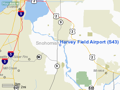
| Location |
Snohomish, Washington |
| Elevation AMSL |
16 ft / 5 m |
| Coordinates |
47°54′29.3510″N 122°06′19.4660″W / 47.90815306°N 122.10540722°W / 47.90815306; -122.10540722 |
| Website |
harveyfield.com |
| Runways |
| Direction |
Length |
Surface |
| ft |
m |
| 33R/15L |
2750 |
838 |
Asphalt |
| 33L/15R |
2660 |
811 |
Turf |
| Statistics (2006) |
| Passengers |
Unknown |
| Aircraft movements |
140,700 |
| Info from Harvey Field website and Snohomish County Business Journal |
Harvey Airfield, a.k.a. Harvey Field, (Its identifier is S43), is a small airport located in Snohomish, Washington. The airfield has one 2,750-foot (840 m) asphalt runway, one 2,660-foot (810 m) turf runway and fourteen hangar bays. It covers an area of approximately 76 acres (310,000 m) and is home to over 350 based aircraft including six helicopters and eight multi-engine planes, and nearly two dozen businesses including a hot-air balloon charter business. History
Harvey Airfield was established in 1944 by Noble and Eldon Harvey and Wesley Loback on the Harvey family's property. In 1947, the family added a restaurant, administration building, and a maintenance shop. The airfield was run by Eldon and Marjorie until Richard and Kandace Harvey began managing airfield operations in the early 1970s. After Richard Harvey died due to cancer in 1995, Kandace Harvey took over ownership and operation of the airport with her four children. They have managed the airfield to date.
Tourism
Since its establishment, Harvey Airfield has played a key role in attracting tourists to Snohomish. It offers balloon, helicopter and biplane rides to tourists, as well as skydiving.
Skydiving
Harvey is home to the Seattle Skydivers, the oldest parachuting club in the United States. Tyson Harvey is the General Manager of Skydive Snohomish, the skydiving charter on the field. The business oversees almost 20,000 jumps every year, most of which are done by Todd Higley, Master Parachute Rigger, who is Tyson's chief adviser and also flies and repairs the center's jump planes, which include a Cessna 182, King Air, Twin Otter, B-17, DC-3, and the worlds only flying example of the Windrider Scorpion Mark II. Todd has been skydiving for 20 years and holds many world records.
Aircraft
Harvey Field is home to over 350-based aircraft and oversees over 140,000 operations per year.
Issues and Goals
In an article for the Snohomish County Business Journal, Kandace Harvey said, “I face three major challenges: land-use and zoning issues as the area grows around us, operating an airport and industrial park in a flood plain, and aircraft noise, We don’t have a lot of difficulty with the sparsely settled rural residential area around us, but at the north end of our runway, the city of Snohomish is close by, just over the Snohomish River. We do get noise complaints from residents of two blocks of homes there. If our zoning will let us continue to grow, we want to extend our runway by 1,000 feet (300 m), which will put aircraft taking off to the north at least another 500 to 700 feet (210 m) higher. People in town would hardly notice it anymore.”
Benefits
A 2001 study by the Washington state Department of Transportation’s Aviation Division credited Harvey Field for providing nearly 450 jobs, more than $7.5 million in annual payrolls and an economic impact on the local community of more than $22.2 million each year. As stated above, the airfield also provides a base for tourism.
Sources
- Snohomish County Business Journal article on Harvey July 2006
The above content comes from Wikipedia and is published under free licenses – click here to read more.
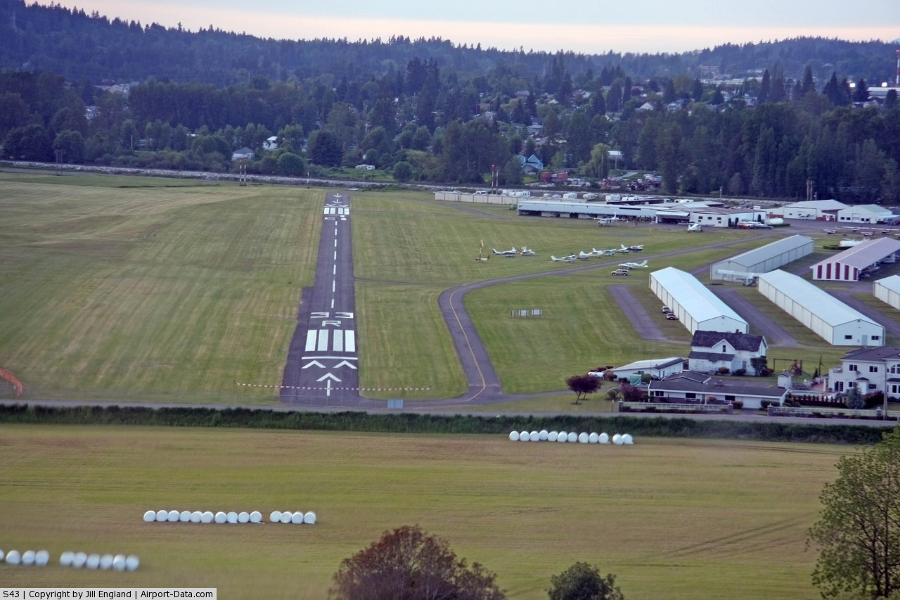
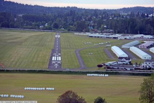
 |
(Click on the photo to enlarge) |
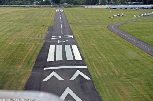
 |
(Click on the photo to enlarge) |
Location & QuickFacts
| FAA Information Effective: | 2008-09-25 |
| Airport Identifier: | S43 |
| Airport Status: | Operational |
| Longitude/Latitude: | 122-06-08.8497W/47-54-17.1212N
-122.102458/47.904756 (Estimated) |
| Elevation: | 16 ft / 4.88 m (Estimated) |
| Land: | 145 acres |
| From nearest city: | 1 nautical miles SW of Snohomish, WA |
| Location: | Snohomish County, WA |
| Magnetic Variation: | 21E (1985) |
Owner & Manager
| Ownership: | Privately owned |
| Owner: | K Harvey |
| Address: | 9900 Airport Way
Snohomish, WA 98296 |
| Phone number: | 360-568-1541 |
| Manager: | K Harvey |
| Address: | 9900 Airport Way
Snohomish, WA 98296 |
| Phone number: | 360-568-1541 |
Airport Operations and Facilities
| Airport Use: | Open to public |
| Wind indicator: | Yes
ONE WIND CONE ONE TEE. |
| Segmented Circle: | No
NON STD TRAFFIC PATTERN INDICATOR LCTD NEAR WIND CONE. |
| Control Tower: | No |
| Lighting Schedule: | DUSK-DAWN |
| Landing fee charge: | No |
| Sectional chart: | Seattle |
| Region: | ANM - Northwest Mountain |
| Traffic Pattern Alt: | 984 ft |
| Boundary ARTCC: | ZSE - Seattle |
| Tie-in FSS: | SEA - Seattle |
| FSS on Airport: | No |
| FSS Toll Free: | 1-800-WX-BRIEF |
| NOTAMs Facility: | SEA (NOTAM-d service avaliable) |
| Federal Agreements: | N |
Airport Communications
| CTAF: | 123.000 |
| Unicom: | 123.000 |
Airport Services
| Fuel available: | 100 A |
| Airframe Repair: | MAJOR |
| Power Plant Repair: | MAJOR |
| Bottled Oxygen: | NONE |
| Bulk Oxygen: | NONE |
Runway Information
Runway 14L/32R
| Dimension: | 2671 x 36 ft / 814.1 x 11.0 m |
| Surface: | ASPH, Good Condition |
| Weight Limit: | Single wheel: 10000 lbs. |
| Edge Lights: | Non-standard lighting system
NSTD LIRL; THLD LIGHTS 360 DEGS GREEN. |
| |
Runway 14L |
Runway 32R |
| Longitude: | 122-06-13.1866W | 122-06-03.0679W |
| Latitude: | 47-54-29.9864N | 47-54-04.5137N |
| Traffic Pattern: | Right | Left |
| Markings: | Numbers only, Good Condition | Numbers only, Good Condition |
| Crossing Height: | 30.00 ft | 30.00 ft |
| Displaced threshold: | 452.00 ft
RY14/32 DSPLCD THLDSS MKD BY PAINTED WHITE LINES. | 241.00 ft |
| VASI: | tri-color on right side | tri-color on right side |
| Visual Glide Angle: | 5.00° | 3.00° |
| Obstruction: | 104 ft trees, 750.0 ft from runway, 205 ft left of centerline, 5:1 slope to clear
RWY 14L APCH SLOPE 14:1 TO +40 FT PLINE 590 FT FM DSPLCD THR.
HI VOLTAGE P-LINE 22 FT HIGH 32 FT FM AER 14 & 25 FT FM MARKER LINE AT 106 FT. | 48 ft trees, 927.0 ft from runway, 10 ft right of centerline, 16:1 slope to clear
RWY 32R APCH SLOPE 6:1 FROM DSPLCD THLD.
RD 50' FM THR; +10' FNC POSTS WITH RED LGTS 50' FM THR; 10' LINE WITH LGTS & FLAGS AT 80'. |
|
Runway 14R/32L
| Dimension: | 2671 x 100 ft / 814.1 x 30.5 m |
| Surface: | TURF, |
| |
Runway 14R |
Runway 32L |
| Longitude: | 122-06-14.4674W | 122-06-04.6767W |
| Latitude: | 47-54-29.7564N | 47-54-04.2284N |
| Traffic Pattern: | Left | Left |
| Displaced threshold: | 452.00 ft | 241.00 ft |
| Obstruction: | 40 ft pline, 138.0 ft from runway, 3:1 slope to clear
RWY 14R APCH SLOPE 14:1 FM DSPLCD THR. | 83 ft trees, 324.0 ft from runway, 50 ft right of centerline, 3:1 slope to clear
RWY 32L APPCH SLOPE 6:1 FROM DSPLCD THLD. |
|
Radio Navigation Aids
| ID |
Type |
Name |
Ch |
Freq |
Var |
Dist |
| RNT | NDB | Renton | | 353.00 | 20E | 25.0 nm |
| ODD | NDB | Dondo | | 224.00 | 19E | 33.6 nm |
| BVS | NDB | Skagit/bay View | | 240.00 | 21E | 36.2 nm |
| PWT | NDB | Kitsap | | 206.00 | 20E | 36.3 nm |
| CAN | NDB | Carney | | 274.00 | 20E | 42.1 nm |
| OPZ | NDB | Lopez Island | | 356.00 | 21E | 47.6 nm |
| GR | NDB | Graye | | 216.00 | 18E | 49.7 nm |
| NUW | TACAN | Whidbey Island | 085X | | 21E | 35.1 nm |
| PAE | VOR/DME | Paine | 043X | 110.60 | 20E | 7.1 nm |
| CVV | VOR/DME | Penn Cove | 119X | 117.20 | 19E | 32.3 nm |
| SEA | VORTAC | Seattle | 115X | 116.80 | 19E | 29.4 nm |
| TCM | VORTAC | Mcchord | 033X | 109.60 | 22E | 48.0 nm |
| BFI | VOT | Boeing Field | | 108.60 | | 24.1 nm |
| SEA | VOT | Seattle-tacoma | | 117.50 | | 28.9 nm |
Remarks
- NOISE ABATEMENT PROCEDURES IN EFFECT; CTC AMGR 360-568-1541.
- RY 14L-32R DSPLCD THLDS MKD BY PAINTED WHITE LINES.
- HELICOPTER TRNG WEST OF RYS 500 FT & BLO.
- ARRIVING HELICOPTER TRAFFIC APPROACH HELIPADS FROM EAST. ARRIVING/DEPARTING HELICOPTER TRAFFIC AVOID FLIGHT THRU (PAJA) DROP ZONE.
- ESTABD PRIOR TO 15 MAY 1959.
Images and information placed above are from
http://www.airport-data.com/airport/S43/
We thank them for the data!
| General Info
|
| Country |
United States
|
| State |
WASHINGTON
|
| FAA ID |
S43
|
| Latitude |
47-54-29.351N
|
| Longitude |
122-06-19.466W
|
| Elevation |
16 feet
|
| Near City |
SNOHOMISH
|
We don't guarantee the information is fresh and accurate. The data may
be wrong or outdated.
For more up-to-date information please refer to other sources.
|
|