 |
|
| Grant County International Airport |
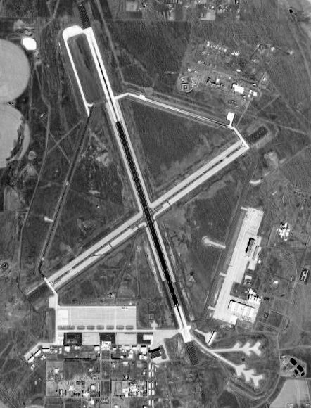 |
| USGS aerial photo, 13 July 1996 |
| IATA: MWH – ICAO: KMWH – FAA LID: MWH |
| Summary |
| Airport type |
Public |
| Owner |
Port of Moses Lake |
| Serves |
Moses Lake, Washington |
| Elevation AMSL |
1,189 ft / 362 m |
| Coordinates |
47°12′31″N 119°19′09″W / 47.20861°N 119.31917°W / 47.20861; -119.31917 |
| Runways |
| Direction |
Length |
Surface |
| ft |
m |
| 14L/32R |
13,503 |
4,116 |
Asphalt/Concrete |
| 4/22 |
10,000 |
3,048 |
Asphalt/Concrete |
| 9/27 |
4,500 |
1,372 |
Concrete |
| 18/36 |
3,327 |
1,014 |
Asphalt |
| 14R/32L |
2,937 |
895 |
Concrete |
| Statistics (2008) |
| Aircraft operations |
69,940 |
| Based aircraft |
43 |
| Source: Federal Aviation Administration |
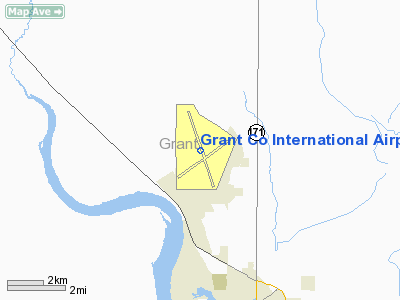
FAA airport diagram Grant County International Airport (IATA: MWH, ICAO: KMWH, FAA LID: MWH) is a public use airport located five nautical miles (9 km) northwest of the central business district of Moses Lake, in Grant County, Washington, United States. It is owned by the Port of Moses Lake.
Its 13,500-foot (4,100 m) runway is one of the longest in the U.S..
Until 1966, the facility was operated by the U.S. Air Force as Larson Air Force Base. Passenger air service to and from Moses Lake ended on June 8, 2010. Overview
With 4,700 acres (1,902 ha) and a main runway 13,500 feet (4,115 m) in length, it is one of the largest airports in the United States. Moses Lake is famous for good flying weather, as it is located on the east side of the Cascade Mountains, in the semi-arid desert of central Washington state.
Grant County International Airport is an alternate landing site for the NASA Space Shuttle.
Scheduled passenger flights on Big Sky Airlines to Boise and Portland were discontinued on September 1, 2006. The service was subsidized by the Essential Air Service program.
The airport had been used for heavy jet training by Japan Airlines for nearly 40 years until the closing of their training offices in March, 2009.
It is also utilized by the U.S. Air Force and Boeing as a testing facility. Most of the traffic at the airport is general and military aviation.
The main campus for Big Bend Community College is also located on the grounds of the airport.
Facilities and aircraft
Grant Co. International Airport covers an area of 4,650 acres (1,882 ha) at an elevation of 1,189 feet (362 m) above mean sea level. It has five paved runways:
- Runway 14L/32R is 13,503 by 200 feet (4,116 x 61 m) with an asphalt/concrete surface
- Runway 4/22 is 10,000 by 100 feet (3,048 x 30 m) with an asphalt/concrete surface
- Runway 9/27 is 3,500 by 90 feet (1,067 x 27 m) with a concrete surface
- Runway 18/36 is 3,327 by 75 feet (1,014 x 23 m) with an asphalt surface
- Runway 14R/32L is 2,936 by 75 feet (895 x 23 m) with a concrete surface
For the 12-month period ending December 31, 2008, the airport had 69,940 aircraft operations, an average of 191 per day: 56% general aviation, 33% military, 8% scheduled commercial and 3% air taxi. At that time there were 43 aircraft based at this airport: 74% single-engine, 19% multi-engine and 7% jet.
The above content comes from Wikipedia and is published under free licenses – click here to read more.
Location & QuickFacts
| FAA Information Effective: | 2008-09-25 |
| Airport Identifier: | MWH |
| Airport Status: | Operational |
| Longitude/Latitude: | 119-19-08.9000W/47-12-30.9000N
-119.319139/47.208583 (Estimated) |
| Elevation: | 1189 ft / 362.41 m (Surveyed) |
| Land: | 4650 acres |
| From nearest city: | 5 nautical miles NW of Moses Lake, WA |
| Location: | Grant County, WA |
| Magnetic Variation: | 18E (1995) |
Owner & Manager
| Ownership: | Publicly owned |
| Owner: | Port Of Moses Lake |
| Address: | 7810 Andrews Street Ne
Moses Lake, WA 98837 |
| Phone number: | 509-762-5363 |
| Manager: | Craig L. Baldwin
EXECUTIVE MANAGER |
| Address: | 7810 Andrews Street Ne
Moses Lake, WA 98837-3204 |
| Phone number: | 509-762-5363 |
Airport Operations and Facilities
| Airport Use: | Open to public |
| Wind indicator: | Yes |
| Segmented Circle: | Yes |
| Control Tower: | Yes |
| Lighting Schedule: | DUSK-DAWN
ACTVT MALSR RY 32R - CTAF. |
| Beacon Color: | Clear-Green (lighted land airport) |
| Landing fee charge: | No |
| Sectional chart: | Seattle |
| Region: | ANM - Northwest Mountain |
| Boundary ARTCC: | ZSE - Seattle |
| Tie-in FSS: | SEA - Seattle |
| FSS on Airport: | No |
| FSS Toll Free: | 1-800-WX-BRIEF |
| NOTAMs Facility: | MWH (NOTAM-d service avaliable) |
| Certification type/date: | I A U 12/1974
PPR FOR ACR OPNS WITH MORE THAN 30 PSGR SEATS 2200-0600 OR FOR ADDNL ARFF INDEX LEVEL SVC CALL AMGR 509-762-5363/5304. |
| Federal Agreements: | NGPY |
Airport Communications
| CTAF: | 118.250 |
| Unicom: | 122.950 |
Airport Services
| Fuel available: | 100 100LLA1+ |
| Airframe Repair: | MAJOR |
| Power Plant Repair: | MAJOR |
| Bottled Oxygen: | NONE |
| Bulk Oxygen: | HIGH |
Runway Information
Runway 04/22
| Dimension: | 10000 x 100 ft / 3048.0 x 30.5 m |
| Surface: | ASPH-CONC, Good Condition |
| Surface Treatment: | Saw-cut or plastic Grooved
FIRST 10000 FT AER 32R GRVD 150 FT WIDE. |
| Weight Limit: | Single wheel: 75000 lbs.
Dual wheel: 100000 lbs.
Dual tandem wheel: 175000 lbs.
Dual dual tandem wheel: 475000 lbs. |
| Edge Lights: | Medium
RY 09/27 MIL LNDG ZONE LGTS ONLY.
NSTD HIRL LOCATED 50 FT FROM RY EDGE MARKINGS. |
| |
Runway 04 |
Runway 22 |
| Longitude: | 119-19-58.5325W | 119-18-01.0982W |
| Latitude: | 47-11-48.2349N | 47-12-45.9838N |
| Elevation: | 1189.00 ft | 1153.00 ft |
| Alignment: | 54 | 127 |
| Traffic Pattern: | Left | Right |
| Markings: | Non-precision instrument, Good Condition | Non-precision instrument, Good Condition |
| Crossing Height: | 50.00 ft | 50.00 ft |
| VASI: | 4-light PAPI on left side | 4-box on left side |
| Visual Glide Angle: | 3.00° | 3.00° |
| Runway End Identifier: | Yes | Yes |
|
Runway 09/27
| Dimension: | 3500 x 90 ft / 1066.8 x 27.4 m |
| Surface: | CONC, Good Condition |
| Surface Treatment: | Saw-cut or plastic Grooved
FIRST 10000 FT AER 32R GRVD 150 FT WIDE. |
| Weight Limit: | Single wheel: 100000 lbs.
Dual wheel: 150000 lbs.
Dual tandem wheel: 270000 lbs.
Dual dual tandem wheel: 475000 lbs. |
| Edge Lights: | Non-standard lighting system
RY 09/27 MIL LNDG ZONE LGTS ONLY.
NSTD HIRL LOCATED 50 FT FROM RY EDGE MARKINGS. |
| |
Runway 09 |
Runway 27 |
| Longitude: | 119-19-00.7701W | 119-18-12.6039W |
| Latitude: | 47-13-03.5992N | 47-12-52.8239N |
| Elevation: | 1162.00 ft | 1152.00 ft |
| Alignment: | 108 | 127 |
| Traffic Pattern: | Left | Right |
|
Runway 14L/32R
| Dimension: | 13503 x 200 ft / 4115.7 x 61.0 m |
| Surface: | ASPH-CONC, Good Condition |
| Surface Treatment: | Saw-cut or plastic Grooved
FIRST 10000 FT AER 32R GRVD 150 FT WIDE. |
| Weight Limit: | Single wheel: 85000 lbs.
Dual wheel: 155000 lbs.
Dual tandem wheel: 320000 lbs.
Dual dual tandem wheel: 600000 lbs. |
| Edge Lights: | Non-standard lighting system
RY 09/27 MIL LNDG ZONE LGTS ONLY.
NSTD HIRL LOCATED 50 FT FROM RY EDGE MARKINGS. |
| |
Runway 14L |
Runway 32R |
| Longitude: | 119-19-35.4306W | 119-18-35.4216W |
| Latitude: | 47-13-32.3673N | 47-11-25.5351N |
| Elevation: | 1168.00 ft | 1166.00 ft |
| Alignment: | 127 | 127 |
| ILS Type: | | ILS
|
| Traffic Pattern: | Left | Right |
| Markings: | Precision instrument, Good Condition | Precision instrument, Good Condition |
| Crossing Height: | 52.00 ft | 75.00 ft |
| VASI: | 6-box on left side | 4-light PAPI on left side |
| Visual Glide Angle: | 3.00° | 3.00° |
| Approach lights: | | MALSR |
| Runway End Identifier: | Yes | |
| Obstruction: | 25 ft bldg, 1081.0 ft from runway, 35:1 slope to clear | , 50:1 slope to clear |
|
Runway 14R/32L
| Dimension: | 2936 x 75 ft / 894.9 x 22.9 m |
| Surface: | CONC, Good Condition |
| Weight Limit: | Single wheel: 100000 lbs.
Dual wheel: 200000 lbs.
Dual tandem wheel: 400000 lbs.
Dual dual tandem wheel: 400000 lbs. |
| |
Runway 14R |
Runway 32L |
| Longitude: | 119-19-48.4477W | 119-19-35.3872W |
| Latitude: | 47-13-26.4893N | 47-12-58.9103N |
| Elevation: | 1168.00 ft | 1170.00 ft |
| Alignment: | 127 | 127 |
| Traffic Pattern: | Right | Left |
| Markings: | Basic, Good Condition | Basic, Good Condition |
| Obstruction: | 9 ft gnd, 620.0 ft from runway, 100 ft right of centerline, 46:1 slope to clear | , 50:1 slope to clear |
|
Runway 18/36
| Dimension: | 3327 x 75 ft / 1014.1 x 22.9 m |
| Surface: | ASPH, Good Condition |
| Weight Limit: | Single wheel: 75000 lbs.
Dual wheel: 170000 lbs.
Dual tandem wheel: 300000 lbs.
Dual dual tandem wheel: 400000 lbs. |
| Edge Lights: | Medium
RY 09/27 MIL LNDG ZONE LGTS ONLY.
NSTD HIRL LOCATED 50 FT FROM RY EDGE MARKINGS. |
| |
Runway 18 |
Runway 36 |
| Longitude: | 119-19-47.4446W | 119-20-02.4514W |
| Latitude: | 47-12-29.8063N | 47-11-58.6046N |
| Elevation: | 1185.00 ft | 1185.00 ft |
| Alignment: | 127 | 18 |
| Traffic Pattern: | Right | Left |
| Markings: | Basic, Good Condition | Basic, Good Condition |
|
Radio Navigation Aids
| ID |
Type |
Name |
Ch |
Freq |
Var |
Dist |
| EAT | FAN MARKER | Malaga | | | 21E | 34.6 nm |
| MW | NDB | Pelly | | 408.00 | 18E | 5.9 nm |
| MWH | VOR/DME | Moses Lake | 097X | 115.00 | 18E | 0.2 nm |
| EAT | VOR/DME | Wenatchee | 047X | 111.00 | 19E | 38.1 nm |
| EPH | VORTAC | Ephrata | 073X | 112.60 | 21E | 11.0 nm |
| ELN | VORTAC | Ellensburg | 126X | 117.90 | 21E | 47.9 nm |
Remarks
- FLOCKS OF LARGE BIRDS INVOF ARPT.
- HVY JET TRNG SFC TO 5000 FT WI 25 MI OF ARPT; PSBL WAKE TURBC FM LARGER ACFT USING RY 14L/32R.
- RY 18/36 AVBL AS AIR CARRIER TWY MOVEMENT AREA ONLY.
- TWY G UNLGTD.
- RY DISTANCE MARKERS RY 14L/32R AND RY 04/22.
- RY 09/27 USED AS ASSAULT STRIP BY C-17 ACFT.
- EXTENSIVE HVY MIL JET ACFT NIGHT TRAINING 1900PM-0300AM LCL DAILY. ANNOUNCE LANDING INTENTIONS ON CTAF AFTER ATCT CLSD.
- RUNWAY 9-27 AND TAXIWAY FOXTROT NOT VISIBLE FROM THE ATCT.
Images and information placed above are from
http://www.airport-data.com/airport/MWH/
We thank them for the data!
| General Info
|
| Country |
United States
|
| State |
WASHINGTON
|
| FAA ID |
MWH
|
| Latitude |
47-12-27.749N
|
| Longitude |
119-19-12.683W
|
| Elevation |
1185 feet
|
| Near City |
MOSES LAKE
|
We don't guarantee the information is fresh and accurate. The data may
be wrong or outdated.
For more up-to-date information please refer to other sources.
|
|


