 |
|
| Ephrata Municipal Airport |
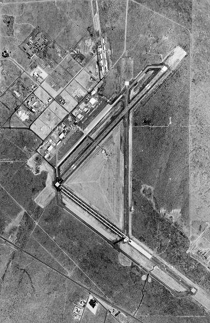 |
| 1996 USGS airphoto |
| IATA: EPH – ICAO: KEPH |
| Summary |
| Airport type |
Public |
| Operator |
Port District No. 9 of Grant County |
| Location |
Ephrata, Washington |
| Elevation AMSL |
1,275 ft / 388.6 m |
| Coordinates |
47°18′27″N 119°30′57″W / 47.3075°N 119.51583°W / 47.3075; -119.51583Coordinates: 47°18′27″N 119°30′57″W / 47.3075°N 119.51583°W / 47.3075; -119.51583 |
| Runways |
| Direction |
Length |
Surface |
| ft |
m |
| 2/20 |
6,700 |
2,042 |
Asphalt |
| 11/29 |
3,843 |
1,171 |
Concrete |
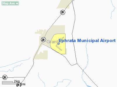
Ephrata Municipal Airport (IATA: EPH, ICAO: KEPH) is a public airport located two miles (3 km) southeast of the central business district (CBD) of Ephrata, a city in Grant County, Washington, USA. The airport covers 2,300 acres (931 ha) and has two runways. History
Established in 1939 as Epharata Army Air Base. It was used initially as a support airfield for bombing and gunnery ranges in the area (Seven Mile Gunnery School). Transferred to Fourth Air Force in 1940 as a group training airfield for B-17 Flying Fortress heavy bombardment units, with new aircraft being obtained from Boeing near Seattle. Later reassigned to Second Air Force when heavy bombardment group training was reassigned to that command. Also used by Air Technical Service Command as an aircraft maintenance and supply depot.
Closed in late 1945 and turned over to War Assets Administration (WAA) for disposal. Transferred to Grant County and developed into a commercial airport in the late 1940s.
The above content comes from Wikipedia and is published under free licenses – click here to read more.
Location & QuickFacts
| FAA Information Effective: | 2008-09-25 |
| Airport Identifier: | EPH |
| Airport Status: | Operational |
| Longitude/Latitude: | 119-31-00.7912W/47-18-29.5808N
-119.516886/47.308217 (Estimated) |
| Elevation: | 1275 ft / 388.62 m (Surveyed) |
| Land: | 2300 acres |
| From nearest city: | 2 nautical miles SE of Ephrata, WA |
| Location: | Grant County, WA |
| Magnetic Variation: | 20E (1965) |
Owner & Manager
| Ownership: | Publicly owned |
| Owner: | Port Dist No 9 Grant Co |
| Address: | Port Of Ephrata Po Box 1089
Ephrata, WA 98823 |
| Phone number: | 509-754-3508 |
| Manager: | Michael Wren |
| Address: | Po Box 1089
Ephrata, WA 98823 |
| Phone number: | 509-754-3508 |
Airport Operations and Facilities
| Airport Use: | Open to public |
| Wind indicator: | Yes |
| Segmented Circle: | Yes |
| Control Tower: | No |
| Lighting Schedule: | DUSK-DAWN
ACTVT MIRL RY 11/29 - CTAF. MIRL RY 02/20, VASI RYS 02 & 20, REIL RYS 11,29, & 20, & PAPI RY 29 OPR SS-SR. |
| Beacon Color: | Clear-Green (lighted land airport) |
| Landing fee charge: | No |
| Sectional chart: | Seattle |
| Region: | ANM - Northwest Mountain |
| Boundary ARTCC: | ZSE - Seattle |
| Tie-in FSS: | SEA - Seattle |
| FSS on Airport: | No |
| FSS Toll Free: | 1-800-WX-BRIEF |
| NOTAMs Facility: | EPH (NOTAM-d service avaliable) |
| Federal Agreements: | NGPSY3 |
Airport Communications
| CTAF: | 122.800 |
| Unicom: | 122.800
UNICOM MONITORED INTERMITTENTLY. |
Airport Services
| Fuel available: | 100LLA
CREDIT CARD FUEL AVBL 0600-2200. |
| Bottled Oxygen: | NONE |
Runway Information
Runway 02/20
| Dimension: | 6700 x 150 ft / 2042.2 x 45.7 m |
| Surface: | ASPH, Fair Condition |
| Weight Limit: | Single wheel: 60000 lbs.
Dual wheel: 90000 lbs.
Dual tandem wheel: 115000 lbs. |
| Edge Lights: | Medium |
| |
Runway 02 |
Runway 20 |
| Longitude: | 119-31-26.1776W | 119-30-20.2363W |
| Latitude: | 47-18-15.6985N | 47-19-04.2921N |
| Elevation: | 1261.00 ft | 1274.00 ft |
| Alignment: | 43 | 127 |
| Traffic Pattern: | Right | Left |
| Markings: | Non-precision instrument, Good Condition | Non-precision instrument, Good Condition |
| Crossing Height: | 60.00 ft | 51.00 ft |
| VASI: | 2-box on left side | 2-box on left side |
| Visual Glide Angle: | 3.50° | 3.00° |
| Runway End Identifier: | | Yes |
| Obstruction: | 58 ft gnd, 2450.0 ft from runway, 550 ft left of centerline, 38:1 slope to clear | , 50:1 slope to clear |
|
Runway 03/21
| Dimension: | 3467 x 150 ft / 1056.7 x 45.7 m |
| Surface: | ASPH, |
| |
Runway 03 |
Runway 21 |
| Longitude: | 119-31-28.6300W | 119-30-54.6100W |
| Latitude: | 47-18-24.0500N | 47-18-49.2600N |
| Elevation: | 1261.00 ft | 1262.00 ft |
| Alignment: | 43 | 127 |
| Traffic Pattern: | Left | Left |
|
Runway 11/29
| Dimension: | 3843 x 60 ft / 1171.3 x 18.3 m |
| Surface: | ASPH, Good Condition |
| Weight Limit: | Single wheel: 40000 lbs.
Dual wheel: 53000 lbs.
Dual tandem wheel: 105000 lbs. |
| Edge Lights: | Medium |
| |
Runway 11 |
Runway 29 |
| Longitude: | 119-31-26.2968W | 119-30-42.1920W |
| Latitude: | 47-18-16.6398N | 47-17-53.4435N |
| Elevation: | 1261.00 ft | 1257.00 ft |
| Alignment: | 127 | 127 |
| Traffic Pattern: | Left | Left |
| Markings: | Basic, Good Condition | Basic, Good Condition |
| Crossing Height: | 0.00 ft | 40.00 ft |
| VASI: | | 2-light PAPI on left side |
| Visual Glide Angle: | 0.00° | 3.00° |
| Runway End Identifier: | Yes | Yes |
| Obstruction: | 52 ft gnd, 1666.0 ft from runway, 293 ft left of centerline, 28:1 slope to clear | , 50:1 slope to clear |
|
Radio Navigation Aids
| ID |
Type |
Name |
Ch |
Freq |
Var |
Dist |
| EAT | FAN MARKER | Malaga | | | 21E | 25.5 nm |
| MW | NDB | Pelly | | 408.00 | 18E | 15.2 nm |
| MWH | VOR/DME | Moses Lake | 097X | 115.00 | 18E | 10.0 nm |
| EAT | VOR/DME | Wenatchee | 047X | 111.00 | 19E | 28.8 nm |
| EPH | VORTAC | Ephrata | 073X | 112.60 | 21E | 5.6 nm |
| ELN | VORTAC | Ellensburg | 126X | 117.90 | 21E | 42.1 nm |
Remarks
- RY 11/29; PARALLEL TWY TO 11/29 & 3 CONNECTOR TWYS NON AIR CARRIER MOVEMENT AREA.
- LNDG ON RWY 11 BY ALL ACFT ARE DISCOURAGED DURING GLIDER OPNS DUE TO TFC CONFLICTS.
- AGRICULTURAL SPRAY PLANES OPERATING FM APR - SEP WITH LOW LEVEL TFC PATTERNS DURG DALGT HRS.
- BE ALERT AEROBATIC ACFT ACTIVITY OVER CENTER OF AIRPORT.
- ULTRA LIGHT ACTIVITY INVOF ARPT.
Images and information placed above are from
http://www.airport-data.com/airport/EPH/
We thank them for the data!
| General Info
|
| Country |
United States
|
| State |
WASHINGTON
|
| FAA ID |
EPH
|
| Latitude |
47-18-27.300N
|
| Longitude |
119-30-57.200W
|
| Elevation |
1276 feet
|
| Near City |
EPHRATA
|
We don't guarantee the information is fresh and accurate. The data may
be wrong or outdated.
For more up-to-date information please refer to other sources.
|
|


