|
|
 |
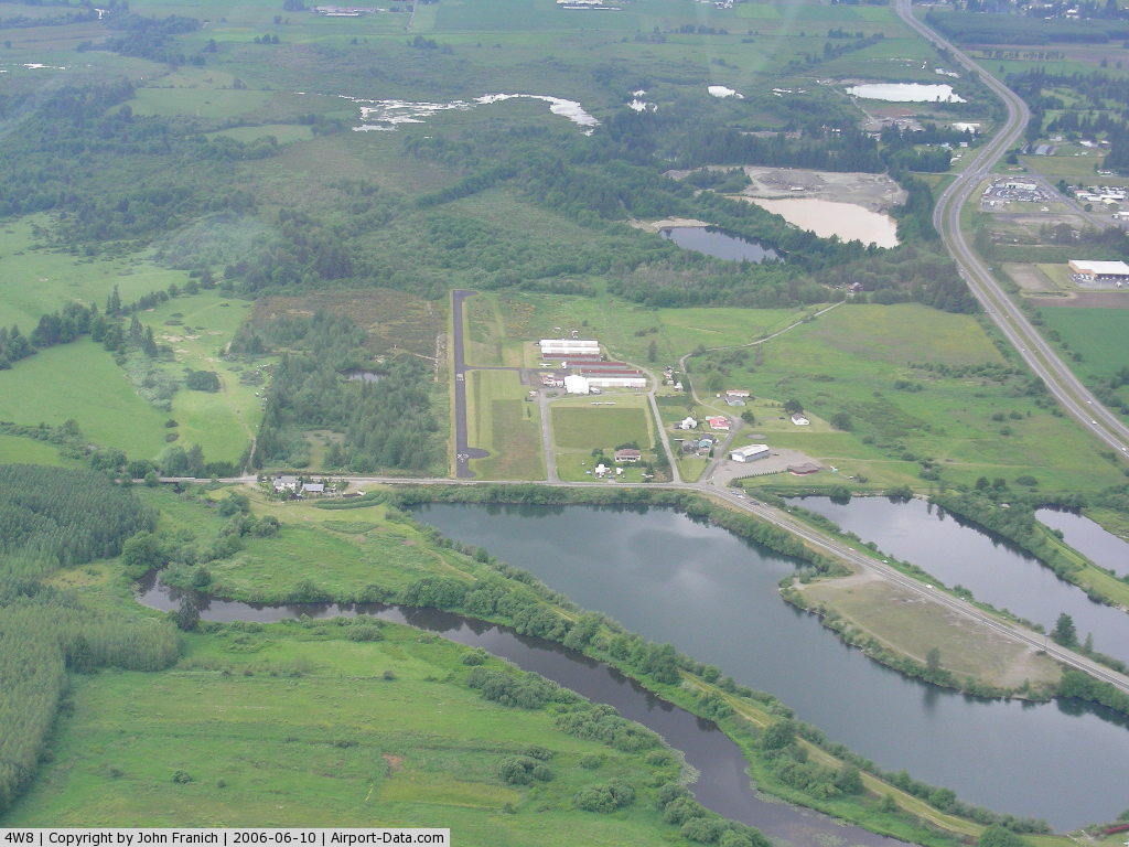
(Click on the photo to enlarge) |
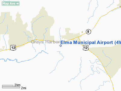
Location & QuickFacts
| FAA Information Effective: | 2008-09-25 |
| Airport Identifier: | 4W8 |
| Airport Status: | Operational |
| Longitude/Latitude: | 123-25-46.7620W/46-59-25.9440N
-123.429656/46.990540 (Estimated) |
| Elevation: | 35 ft / 10.67 m (Estimated) |
| Land: | 30 acres |
| From nearest city: | 1 nautical miles SW of Elma, WA |
| Location: | Grays Harbor County, WA |
| Magnetic Variation: | 20E (1985) |
Owner & Manager
| Ownership: | Privately owned |
| Owner: | Jack Duffy |
| Address: | 34 Airport Way
Elma, WA 98541-9115 |
| Phone number: | 360-482-2228 |
| Manager: | Mike Blake |
| Address: | 34 Airport Way # 30
Elma, WA 98541-9115 |
| Phone number: | 360-593-3439 |
Airport Operations and Facilities
| Airport Use: | Open to public |
| Wind indicator: | Yes |
| Segmented Circle: | No |
| Control Tower: | No |
| Lighting Schedule: | DUSK-DAWN
ACTVT NSTD MIRL RY 07/25 - CTAF. |
| Beacon Color: | Clear-Green (lighted land airport) |
| Landing fee charge: | No |
| Sectional chart: | Seattle |
| Region: | ANM - Northwest Mountain |
| Traffic Pattern Alt: | 800 ft |
| Boundary ARTCC: | ZSE - Seattle |
| Tie-in FSS: | SEA - Seattle |
| FSS on Airport: | No |
| FSS Toll Free: | 1-800-WX-BRIEF |
| NOTAMs Facility: | SEA (NOTAM-d service avaliable) |
Airport Communications
| CTAF: | 122.800 |
| Unicom: | 122.800 |
Airport Services
| Bottled Oxygen: | NONE |
| Bulk Oxygen: | NONE |
Runway Information
Runway 07/25
| Dimension: | 2280 x 30 ft / 694.9 x 9.1 m |
| Surface: | ASPH, Good Condition |
| Edge Lights: | Non-standard lighting system
SW END THLD LGTS 2-360 DEG GREEN; 2-360 DEG RED; NE END THLD LGTS 4-180 DEG GREEN & 180 DEG RED. NSTD MIRL. RY 25 DSPLCD THLD UNLIGHTED; 2095 FT OF RY 07/25 AVBL FOR NIGHT OPNS. |
| |
Runway 07 |
Runway 25 |
| Longitude: | 123-26-03.1930W | 123-25-30.3310W |
| Latitude: | 46-59-25.4610N | 46-59-26.4260N |
| Alignment: | 88 | 127 |
| Traffic Pattern: | Right | Left |
| Markings: | Nonstandard, Fair Condition
VERY NARROW FADED CNTRLN STRIPE; RWY ID NONSTANDARD DIMENSIONS. | Nonstandard, Fair Condition
VERY NARROW FADED CNTRLN STRIPE; RWY ID NONSTANDARD DIMENSIONS. |
| Displaced threshold: | 0.00 ft | 180.00 ft |
| Obstruction: | 19 ft trees, 200.0 ft from runway, 28 ft left of centerline
RWY 07 +25 FT TREES 0-200 FT FM THLD, 60 FT L. | 33 ft trees, 330.0 ft from runway, 57 ft right of centerline, 3:1 slope to clear
RWY 25 APCH RATIO 3:1 MEASURED AT DSPLCD THR.
BRUSH 30 FT L +3 FT RISE 3 FT FROM THLD ON CNTRLN; +3 FT ROAD AT 38 FT; 25 FT BRUSH & TREES 60-200 FT FROM THLD. |
|
Radio Navigation Aids
| ID |
Type |
Name |
Ch |
Freq |
Var |
Dist |
| MNC | NDB | Mason County | | 348.00 | 19E | 20.9 nm |
| CAN | NDB | Carney | | 274.00 | 20E | 34.9 nm |
| GR | NDB | Graye | | 216.00 | 18E | 35.1 nm |
| LAC | NDB | Lacomas | | 328.00 | 18E | 35.8 nm |
| TDO | NDB | Toledo | | 219.00 | 20E | 39.9 nm |
| PWT | NDB | Kitsap | | 206.00 | 20E | 40.8 nm |
| OLM | VORTAC | Olympia | 081X | 113.40 | 19E | 21.7 nm |
| HQM | VORTAC | Hoquiam | 124X | 117.70 | 19E | 29.6 nm |
| TCM | VORTAC | Mcchord | 033X | 109.60 | 22E | 40.2 nm |
Images and information placed above are from
http://www.airport-data.com/airport/4W8/
We thank them for the data!
| General Info
|
| Country |
United States
|
| State |
WASHINGTON
|
| FAA ID |
4W8
|
| Latitude |
46-59-25.345N
|
| Longitude |
123-25-50.570W
|
| Elevation |
28 feet
|
| Near City |
ELMA
|
We don't guarantee the information is fresh and accurate. The data may
be wrong or outdated.
For more up-to-date information please refer to other sources.
|
|