 |
|
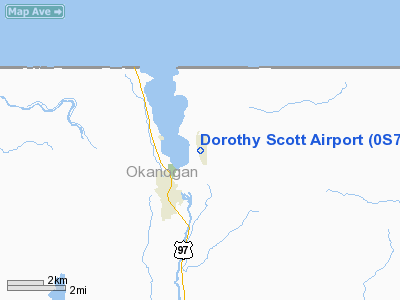
Location & QuickFacts
| FAA Information Effective: | 2008-09-25 |
| Airport Identifier: | 0S7 |
| Airport Status: | Operational |
| Longitude/Latitude: | 119-24-43.0640W/48-57-32.2740N
-119.411962/48.958965 (Estimated) |
| Elevation: | 1064 ft / 324.31 m (Surveyed) |
| Land: | 142 acres |
| From nearest city: | 2 nautical miles NE of Oroville, WA |
| Location: | Okanogan County, WA |
| Magnetic Variation: | 21E (1985) |
Owner & Manager
| Ownership: | Publicly owned |
| Owner: | City Of Oroville |
| Address: | Po Box 2200
Oroville, WA 98844 |
| Phone number: | 509-476-2926 |
| Manager: | Steve Johnston |
| Address: | Po Box 2200
Oroville, WA 98844 |
| Phone number: | 509-476-2227 |
Airport Operations and Facilities
| Airport Use: | Open to public |
| Wind indicator: | Yes |
| Segmented Circle: | Yes |
| Control Tower: | No |
| Lighting Schedule: | DUSK-DAWN
ACTVT MIRL RY 15/33 - CTAF. |
| Beacon Color: | Clear-Green (lighted land airport)
ARPT ROTG BCN LCTD 1500' EAST OF CNTRLN OF ARPT ON TOP OF HILL APRX 900' ABOVE ARPT ELEV. |
| Landing fee charge: | No |
| Sectional chart: | Seattle |
| Region: | ANM - Northwest Mountain |
| Boundary ARTCC: | ZSE - Seattle |
| Tie-in FSS: | SEA - Seattle |
| FSS on Airport: | No |
| FSS Toll Free: | 1-800-WX-BRIEF |
| NOTAMs Facility: | SEA (NOTAM-d service avaliable) |
| Federal Agreements: | N |
Airport Communications
Airport Services
| Fuel available: | 100LL |
| Airframe Repair: | MAJOR |
| Power Plant Repair: | MAJOR |
| Bottled Oxygen: | NONE |
| Bulk Oxygen: | NONE |
Runway Information
Runway 15/33
| Dimension: | 4014 x 50 ft / 1223.5 x 15.2 m |
| Surface: | ASPH, Good Condition |
| Weight Limit: | Single wheel: 5000 lbs. |
| Edge Lights: | Medium |
| |
Runway 15 |
Runway 33 |
| Longitude: | 119-24-50.1150W | 119-24-36.0160W |
| Latitude: | 48-57-51.5230N | 48-57-13.0250N |
| Elevation: | 1064.00 ft | 1058.00 ft |
| Alignment: | 127 | 127 |
| Traffic Pattern: | Right | Left |
| Markings: | Basic, Good Condition | Basic, Good Condition |
| Crossing Height: | 45.00 ft | 0.00 ft |
| VASI: | 2-light PAPI on left side | |
| Visual Glide Angle: | 3.00° | 0.00° |
| Obstruction: | , 50:1 slope to clear | 12 ft road, 200.0 ft from runway |
|
Radio Navigation Aids
| ID |
Type |
Name |
Ch |
Freq |
Var |
Dist |
| ON | NDB | Okanagan | | 356.00 | 20E | 23.9 nm |
| OMK | NDB | Omak | | 219.00 | 19E | 30.7 nm |
| YYF | NDB | Penticton | | 290.00 | 21E | 32.7 nm |
| UNT | NDB | Naramata | | 312.00 | 21E | 39.1 nm |
| YDC | VORTAC | Princeton | 086X | 113.90 | 21E | 45.5 nm |
Remarks
- CUSTOMS TELEPHONE 509-476-2955.
- BRUSH, ROADS & TIE DOWNS IN PRIMARY SFC.
- FLIGHT NOTIFICTION SERVICE (ADCUS) AVBL.
- WILDLIFE ADJ TO RY/TWY.
- EXISTED PRIOR TO 1959
Images and information placed above are from
http://www.airport-data.com/airport/0S7/
We thank them for the data!
| General Info
|
| Country |
United States
|
| State |
WASHINGTON
|
| FAA ID |
0S7
|
| Latitude |
48-57-32.274N
|
| Longitude |
119-24-43.064W
|
| Elevation |
1064 feet
|
| Near City |
OROVILLE
|
We don't guarantee the information is fresh and accurate. The data may
be wrong or outdated.
For more up-to-date information please refer to other sources.
|
|


