|
|
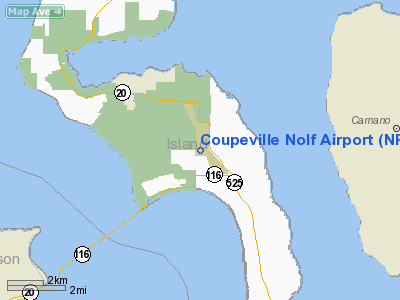
| NOLF Coupeville |
 |
| IATA: none – ICAO: KNRA – FAA LID: NRA |
| Summary |
| Airport type |
Military |
| Operator |
US Navy |
| Location |
Island County, near Coupeville, Washington |
| Elevation AMSL |
199 ft / 61 m |
| Coordinates |
48°11′00″N 122°38′00″W / 48.1833333°N 122.6333333°W / 48.1833333; -122.6333333Coordinates: 48°11′00″N 122°38′00″W / 48.1833333°N 122.6333333°W / 48.1833333; -122.6333333 |
| Runways |
| Direction |
Length |
Surface |
| ft |
m |
| 14/32 |
5,400 |
1646 |
Concrete |
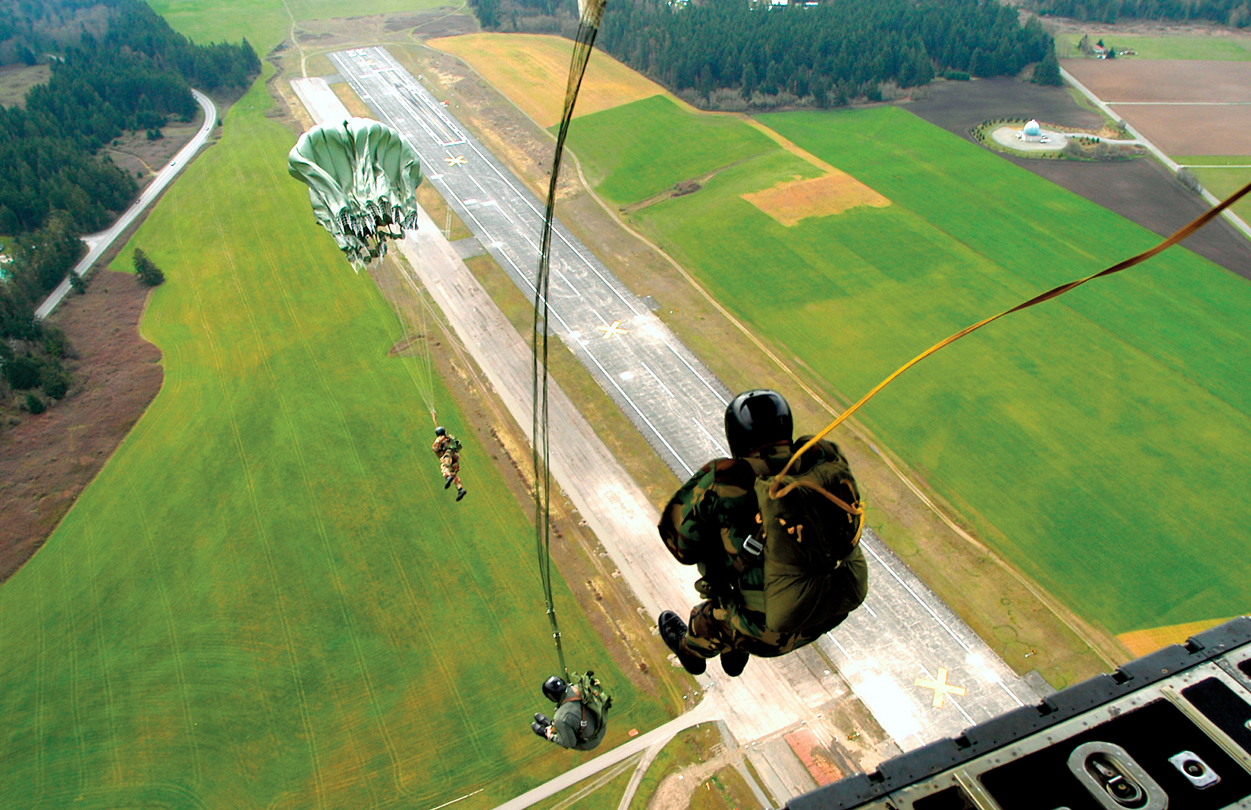
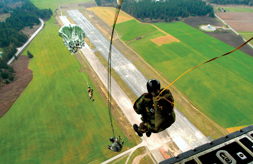
Naval Outlying Field Coupeville (ICAO: KNRA, FAA LID: NRA) is a military airport located two miles (3 km) southeast of Coupeville, Washington, in Island County. It is owned by the United States Navy. NOLF Coupeville nearly touches State Route 20 and is about 10 miles south of NAS Whidbey Island.
The above content comes from Wikipedia and is published under free licenses – click here to read more.
Location & QuickFacts
| FAA Information Effective: | 2008-09-25 |
| Airport Identifier: | NRA |
| Airport Status: | Operational |
| Longitude/Latitude: | 122-38-00.0000W/48-11-00.0000N
-122.633333/48.183333 (Estimated) |
| Elevation: | 199 ft / 60.66 m (Estimated) |
| Land: | 0 acres |
| From nearest city: | 3 nautical miles SE of Coupeville, WA |
| Location: | Island County, WA |
| Magnetic Variation: | 19E (2000) |
Owner & Manager
| Ownership: | Navy owned |
| Owner: | Us Navy |
| Address: | Commanding Officer Attn: Code Aot, 3730 North Charles
Oak Harbor, WA 98278 |
| Phone number: | 360-257-2681/2 |
| Manager: | Us Navy |
| Address: | Commanding Officer Attn: Code Aot, 3730 North Charles
Oak Harbor, WA 98278 |
| Phone number: | 360-257-2681/2 |
Airport Operations and Facilities
| Airport Use: | Private
STRICTLY MILITARY USE ONLY. |
| Wind indicator: | Yes |
| Segmented Circle: | No |
| Control Tower: | No |
| Lighting Schedule: | DUSK-DAWN
BCN OPRS DUSK-DAWN AND DURG IMC. |
| Beacon Color: | Split-Clear-Green (lighted military airport) |
| Sectional chart: | Seattle |
| Region: | ANM - Northwest Mountain |
| Boundary ARTCC: | ZSE - Seattle |
| Tie-in FSS: | SEA - Seattle |
| FSS Toll Free: | 1-800-WX-BRIEF |
| NOTAMs Facility: | NUW (NOTAM-d service avaliable) |
Runway Information
Runway 14/32
| Dimension: | 5400 x 200 ft / 1645.9 x 61.0 m |
| Surface: | CONC, |
| Edge Lights: | Medium |
| |
Runway 14 |
Runway 32 |
| Traffic Pattern: | Right | Right |
|
Radio Navigation Aids
| ID |
Type |
Name |
Ch |
Freq |
Var |
Dist |
| BVS | NDB | Skagit/bay View | | 240.00 | 21E | 19.2 nm |
| OPZ | NDB | Lopez Island | | 356.00 | 21E | 21.2 nm |
| FHR | NDB | Friday Harbor | | 284.00 | 20E | 26.0 nm |
| YJ | NDB | Victoria | | 200.00 | 21E | 41.3 nm |
| CL | NDB | Elwha | | 515.00 | 22E | 41.6 nm |
| PWT | NDB | Kitsap | | 206.00 | 20E | 41.8 nm |
| RNT | NDB | Renton | | 353.00 | 20E | 44.7 nm |
| MB | NDB | Mill Bay | | 293.00 | 21E | 46.5 nm |
| CAN | NDB | Carney | | 274.00 | 20E | 47.2 nm |
| AP | NDB | Active Pass | | 378.00 | 21E | 49.1 nm |
| WC | NDB | White Rock | | 332.00 | 21E | 49.4 nm |
| NUW | TACAN | Whidbey Island | 085X | | 21E | 10.4 nm |
| CVV | VOR/DME | Penn Cove | 119X | 117.20 | 19E | 5.2 nm |
| PAE | VOR/DME | Paine | 043X | 110.60 | 20E | 21.3 nm |
| YYJ | VOR/DME | Victoria | 084X | 113.70 | 21E | 47.1 nm |
| HUH | VORTAC | Whatcom | 077X | 113.00 | 20E | 45.8 nm |
| SEA | VORTAC | Seattle | 115X | 116.80 | 19E | 46.8 nm |
| BFI | VOT | Boeing Field | | 108.60 | | 41.6 nm |
| SEA | VOT | Seattle-tacoma | | 117.50 | | 46.4 nm |
Remarks
- FULL STOP LNDG NOT AUZD UNLESS EMERGENCY.
Images and information placed above are from
http://www.airport-data.com/airport/NRA/
We thank them for the data!
| General Info
|
| Country |
United States
|
| State |
WASHINGTON
|
| FAA ID |
NRA
|
| Latitude |
48-11-00.000N
|
| Longitude |
122-38-00.000W
|
| Elevation |
199 feet
|
| Near City |
COUPEVILLE
|
We don't guarantee the information is fresh and accurate. The data may
be wrong or outdated.
For more up-to-date information please refer to other sources.
|
|