 |
|
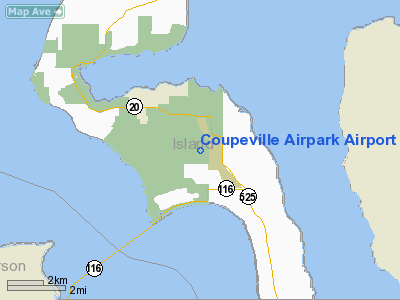
Coupeville Airpark Airport |
Location & QuickFacts
| FAA Information Effective: | 2008-09-25 |
| Airport Identifier: | WN40 |
| Airport Status: | Operational |
| Longitude/Latitude: | 122-38-34.5970W/48-11-25.3510N
-122.642944/48.190375 (Estimated) |
| Elevation: | 200 ft / 60.96 m (Estimated) |
| Land: | 5 acres |
| From nearest city: | 3 nautical miles S of Coupeville, WA |
| Location: | Island County, WA |
| Magnetic Variation: | 21E (1985) |
Owner & Manager
| Ownership: | Privately owned |
| Owner: | Ernest H. Youderian |
| Address: | 585w-500so
Coupeville, WA 98239 |
| Phone number: | 206-678-4147 |
| Manager: | Ernest H. Youderian |
| Address: | 585w-500so
Coupeville, WA 98239 |
| Phone number: | 206-678-4147 |
Airport Operations and Facilities
| Airport Use: | Private |
| Wind indicator: | Yes |
| Segmented Circle: | No |
| Control Tower: | No |
| Landing fee charge: | No |
| Sectional chart: | Seattle |
| Region: | ANM - Northwest Mountain |
| Boundary ARTCC: | ZSE - Seattle |
| Tie-in FSS: | SEA - Seattle |
| FSS on Airport: | No |
| FSS Toll Free: | 1-800-WX-BRIEF |
Runway Information
Runway 06/24
| Dimension: | 2500 x 80 ft / 762.0 x 24.4 m |
| Surface: | TURF, |
| |
Runway 06 |
Runway 24 |
| Traffic Pattern: | Left | Left |
| Obstruction: | 100 ft trees, 400.0 ft from runway | |
|
Radio Navigation Aids
| ID |
Type |
Name |
Ch |
Freq |
Var |
Dist |
| BVS | NDB | Skagit/bay View | | 240.00 | 21E | 19.0 nm |
| OPZ | NDB | Lopez Island | | 356.00 | 21E | 20.6 nm |
| FHR | NDB | Friday Harbor | | 284.00 | 20E | 25.4 nm |
| YJ | NDB | Victoria | | 200.00 | 21E | 40.7 nm |
| CL | NDB | Elwha | | 515.00 | 22E | 41.3 nm |
| PWT | NDB | Kitsap | | 206.00 | 20E | 42.2 nm |
| RNT | NDB | Renton | | 353.00 | 20E | 45.2 nm |
| MB | NDB | Mill Bay | | 293.00 | 21E | 45.9 nm |
| CAN | NDB | Carney | | 274.00 | 20E | 47.5 nm |
| AP | NDB | Active Pass | | 378.00 | 21E | 48.5 nm |
| WC | NDB | White Rock | | 332.00 | 21E | 49.0 nm |
| XX | NDB | Abbotsford | | 344.00 | 21E | 50.0 nm |
| NUW | TACAN | Whidbey Island | 085X | | 21E | 9.9 nm |
| CVV | VOR/DME | Penn Cove | 119X | 117.20 | 19E | 4.6 nm |
| PAE | VOR/DME | Paine | 043X | 110.60 | 20E | 21.9 nm |
| YYJ | VOR/DME | Victoria | 084X | 113.70 | 21E | 46.5 nm |
| HUH | VORTAC | Whatcom | 077X | 113.00 | 20E | 45.4 nm |
| SEA | VORTAC | Seattle | 115X | 116.80 | 19E | 47.3 nm |
| BFI | VOT | Boeing Field | | 108.60 | | 42.1 nm |
| SEA | VOT | Seattle-tacoma | | 117.50 | | 47.0 nm |
Remarks
- CTC WHIDBEY NAS ON 127.9 OR APCH CTL 118.2 OR ATIS ON 134.15. FOR ARPT TFC AREA HOT OR COLD JET TFC ON DLNG & TKOF.
- AIRPARK APPROVED FOR PERSONAL USE ONLY.
Images and information placed above are from
http://www.airport-data.com/airport/WN40/
We thank them for the data!
| General Info
|
| Country |
United States
|
| State |
WASHINGTON
|
| FAA ID |
WN40
|
| Latitude |
48-11-25.351N
|
| Longitude |
122-38-34.597W
|
| Elevation |
200 feet
|
| Near City |
COUPEVILLE
|
We don't guarantee the information is fresh and accurate. The data may
be wrong or outdated.
For more up-to-date information please refer to other sources.
|
|


