|
|
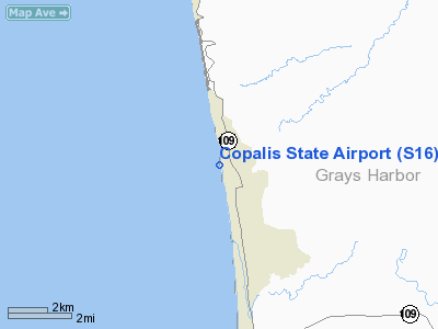
Coordinates: 47°07′29″N 124°11′05″W / 47.12472°N 124.18472°W / 47.12472; -124.18472
| Copalis State Airport |
 |
| IATA: none – ICAO: none – FAA LID: S16 |
| Summary |
| Airport type |
Public |
| Owner |
Washington State DOT |
| Serves |
Copalis Beach, Washington |
| Elevation AMSL |
1 ft / 0 m |
| Runways |
| Direction |
Length |
Surface |
| ft |
m |
| 14/32 |
4,500 |
1,372 |
Sand |
| Statistics (2006) |
| Aircraft operations |
200 |
| Source: Federal Aviation Administration |
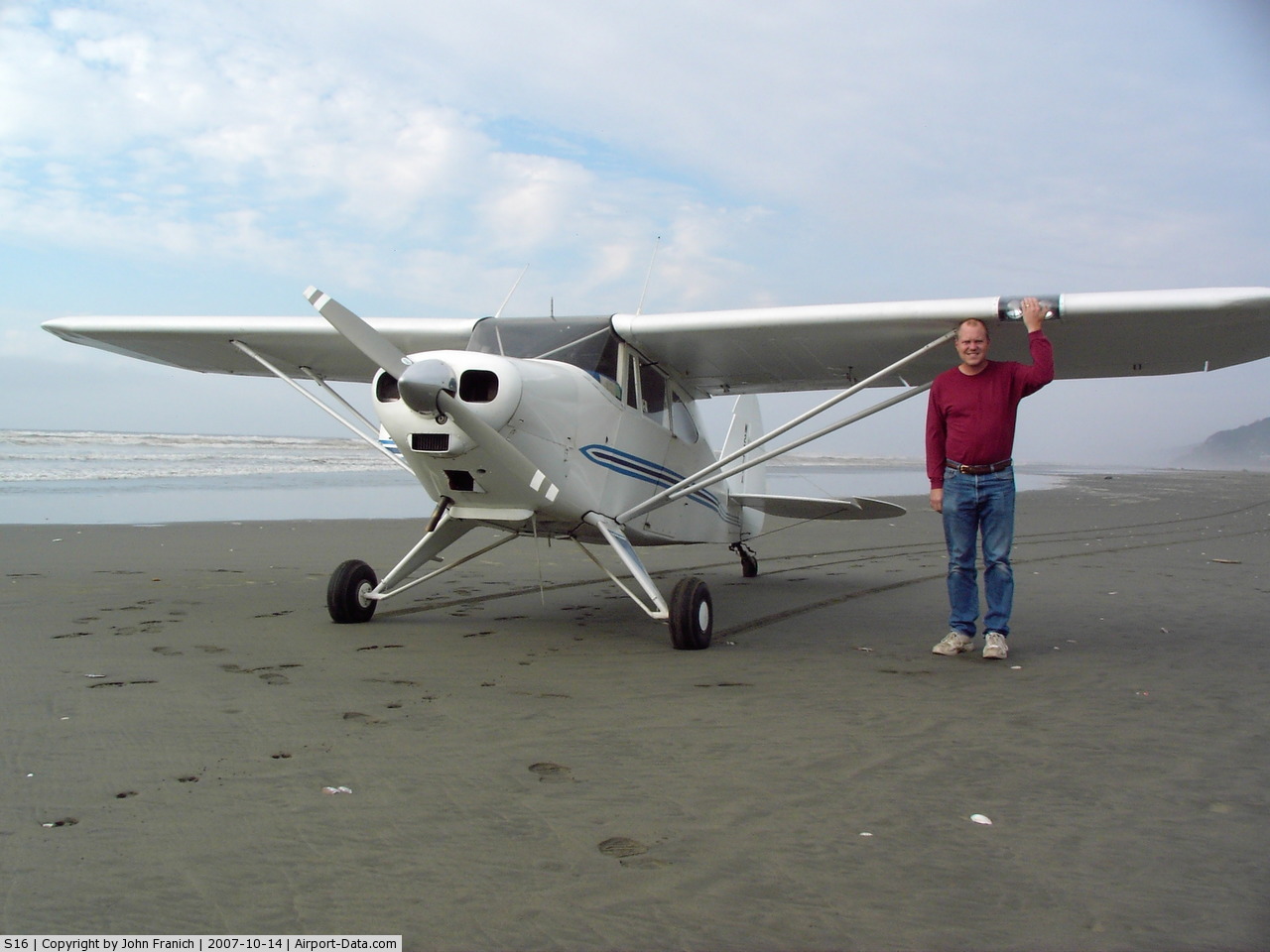
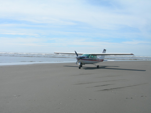
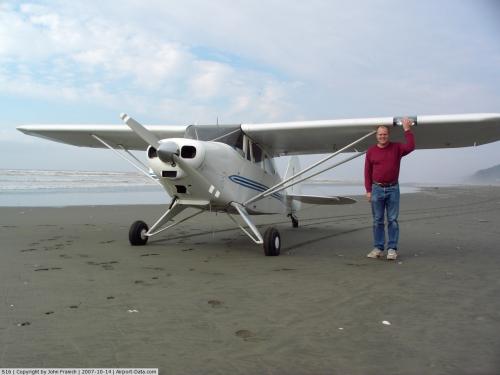
Copalis State Airport (FAA LID: S16), formerly Copalis Beach State Airport, is located on the beach near Copalis Beach, in Grays Harbor County, Washington, United States. It is the only airport in the United States that is located on an ocean beach.
The runway is the 4,500-foot (1,400 m) stretch of ocean beach from the Copalis River on the south to the rocks a mile north. It is only available during low tide.
The above content comes from Wikipedia and is published under free licenses – click here to read more.
 |
(Click on the photo to enlarge) |
Location & QuickFacts
| FAA Information Effective: | 2008-09-25 |
| Airport Identifier: | S16 |
| Airport Status: | Operational |
| Longitude/Latitude: | 124-11-04.6360W/47-07-29.3070N
-124.184621/47.124808 (Estimated) |
| Elevation: | 1 ft / 0.30 m (Estimated) |
| Land: | 16 acres |
| From nearest city: | 2 nautical miles NW of Copalis, WA |
| Location: | Grays Harbor County, WA |
| Magnetic Variation: | 20E (1985) |
Owner & Manager
| Ownership: | Publicly owned |
| Owner: | Washington State Aviation Div |
| Address: | 3704 172nd Street Ne, Suite K2, Po Box 3367
Arlington, WA 98223-6336 |
| Phone number: | 360-651-6300 |
| Manager: | Jim Scott |
| Address: | 3704 172nd Street Ne, Suite K2, Po Box 3367
Arlington, WA 98223-6336 |
| Phone number: | 360-651-6300 |
Airport Operations and Facilities
| Airport Use: | Open to public |
| Wind indicator: | No |
| Segmented Circle: | No |
| Control Tower: | No |
| Landing fee charge: | No |
| Sectional chart: | Seattle |
| Region: | ANM - Northwest Mountain |
| Boundary ARTCC: | ZSE - Seattle |
| Tie-in FSS: | SEA - Seattle |
| FSS on Airport: | No |
| FSS Toll Free: | 1-800-WX-BRIEF |
| NOTAMs Facility: | SEA (NOTAM-d service avaliable) |
Airport Communications
Airport Services
| Airframe Repair: | NONE |
| Power Plant Repair: | NONE |
| Bottled Oxygen: | NONE |
| Bulk Oxygen: | NONE |
Runway Information
Runway 14/32
| Dimension: | 4500 x 150 ft / 1371.6 x 45.7 m |
| Surface: | SAND, Fair Condition |
| |
Runway 14 |
Runway 32 |
| Traffic Pattern: | Right | Left |
| Obstruction: | 2 ft rock | , 50:1 slope to clear |
|
Radio Navigation Aids
| ID |
Type |
Name |
Ch |
Freq |
Var |
Dist |
| MNC | NDB | Mason County | | 348.00 | 19E | 45.5 nm |
| HQM | VORTAC | Hoquiam | 124X | 117.70 | 19E | 10.8 nm |
Remarks
- RY AVBL WHEN TIDE IS LOW & WATCH FOR DEBRIS; LND ON DAMP SAND; DRY SAND IS EXTREMELY SOFT.
- CTC WASHINGTON STATE AVIATION DIVISION 360-651-6300 OR 1-800-552-0666 FOR FACILITY INFORMATION PRIOR TO USE.
- VEHICLES; PEDESTRIANS & ANIMALS ON & INVOF RY.
- RIVER COURSE CHANGE MAY ALTER RY LENGTH.
- STREAM CROSSING 1500 FT FROM THE END OF RY 14.
- EXISTED PRIOR TO 1959.
Images and information placed above are from
http://www.airport-data.com/airport/S16/
We thank them for the data!
| General Info
|
| Country |
United States
|
| State |
WASHINGTON
|
| FAA ID |
S16
|
| Latitude |
47-07-29.307N
|
| Longitude |
124-11-04.636W
|
| Elevation |
1 feet
|
| Near City |
COPALIS
|
We don't guarantee the information is fresh and accurate. The data may
be wrong or outdated.
For more up-to-date information please refer to other sources.
|
|