 |
|
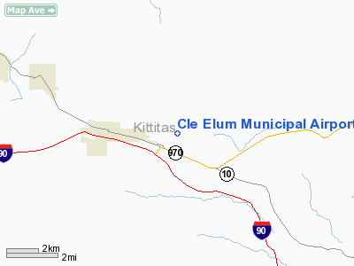
Location & QuickFacts
| FAA Information Effective: | 2008-09-25 |
| Airport Identifier: | S93 |
| Airport Status: | Operational |
| Longitude/Latitude: | 120-53-00.3100W/47-11-39.3340N
-120.883419/47.194259 (Estimated) |
| Elevation: | 1944 ft / 592.53 m (Surveyed) |
| Land: | 160 acres |
| From nearest city: | 1 nautical miles E of Cle Elum, WA |
| Location: | Kittitas County, WA |
| Magnetic Variation: | 20E (1985) |
Owner & Manager
| Ownership: | Publicly owned |
| Owner: | City Of Cle Elum |
| Address: | 119 West 1st Street
Cle Elum, WA 98922 |
| Phone number: | 509-674-2262 |
| Manager: | Jim Leonard |
| Address: | 119 West 1st Street
Cle Elum, WA 98922 |
| Phone number: | 509-674-2262 |
Airport Operations and Facilities
| Airport Use: | Open to public |
| Wind indicator: | Yes |
| Segmented Circle: | Yes
SEGMENTED CIRCLE MRKD WITH TIRES PAINTED WHITE. |
| Control Tower: | No |
| Lighting Schedule: | RDO-CTL
ACTVT ROTG BCN & MIRL RY 07/25 - CTAF. |
| Beacon Color: | Clear-Green (lighted land airport) |
| Landing fee charge: | No |
| Sectional chart: | Seattle |
| Region: | ANM - Northwest Mountain |
| Traffic Pattern Alt: | 1000 ft |
| Boundary ARTCC: | ZSE - Seattle |
| Tie-in FSS: | SEA - Seattle |
| FSS on Airport: | No |
| FSS Toll Free: | 1-800-WX-BRIEF |
| NOTAMs Facility: | SEA (NOTAM-d service avaliable) |
| Federal Agreements: | N |
Airport Communications
Airport Services
| Airframe Repair: | NONE |
| Power Plant Repair: | NONE |
| Bottled Oxygen: | NONE |
| Bulk Oxygen: | NONE |
Runway Information
Runway 07/25
| Dimension: | 2552 x 40 ft / 777.8 x 12.2 m |
| Surface: | ASPH, Poor Condition
RY 07/25 POOR CONDITION; RY & TWY LOOSE GRVL, SPALLING, & PAVEMENT MISSING. POWERED ACFT DO NOT USE GRASSY AREA; GLIDERS ONLY. |
| Edge Lights: | Medium
MIRL OTS INDEFLY. |
| |
Runway 07 |
Runway 25 |
| Longitude: | 120-53-18.7720W | 120-52-41.8490W |
| Latitude: | 47-11-38.8300N | 47-11-39.8370N |
| Elevation: | 1944.00 ft | 1938.00 ft |
| Traffic Pattern: | Right | Left |
| Markings: | Basic, Fair Condition | Basic, Fair Condition |
| Crossing Height: | 20.00 ft | 20.00 ft |
| Displaced threshold: | 130.00 ft | 130.00 ft |
| VASI: | 2-light PAPI on left side
RY 7 PAPI OTS INDEFLY. | 2-light PAPI on left side
RY 25 PAPI OTS INDEFLY. |
| Visual Glide Angle: | 4.00° | 4.00° |
| Obstruction: | 76 ft trees, 330.0 ft from runway, 75 ft left of centerline, 1:1 slope to clear
APCH RATIO 3:1 AT DSPLCD THLD.
3' FENCE 15' FM THR -2' DITCH 10' FM THR. | 74 ft , 438.0 ft from runway, 10 ft right of centerline, 3:1 slope to clear
APCH RATIO 5:1 AT DSPLCD THLD.
RWY 25 4' FENCE 50' FM THR FOR WIDTH OF APRX 100' IN APCH, REMAINING FENCE 8' 3' +3' BERM AT 35' -3' DITCH AT 40', 15' BRUSH, +8' BRUSH 35' 25' L OF CNTRLN, + 10' BRUSH 44' 25' R OF CNTRLN. |
|
Radio Navigation Aids
| ID |
Type |
Name |
Ch |
Freq |
Var |
Dist |
| EAT | FAN MARKER | Malaga | | | 21E | 32.0 nm |
| EAT | VOR/DME | Wenatchee | 047X | 111.00 | 19E | 30.1 nm |
| ELN | VORTAC | Ellensburg | 126X | 117.90 | 21E | 20.2 nm |
| YKM | VORTAC | Yakima | 107X | 116.00 | 21E | 41.6 nm |
Remarks
-
- TREES IN TRANSITION AREA.
- WILDLIFE ON & INVOF OF RUNWAY.
- RY 07/25 HAS 3 FT DEEP HOLE (3 FT WIDE 4 FT LONG) 975 FT FM EAST END OF THLD.
- ARPT CLSD INDEFLY.
- ESTABD PRIOR TO 15 MAY 1959.
Images and information placed above are from
http://www.airport-data.com/airport/S93/
We thank them for the data!
| General Info
|
| Country |
United States
|
| State |
WASHINGTON
|
| FAA ID |
S93
|
| Latitude |
47-10-59.433N
|
| Longitude |
120-53-04.290W
|
| Elevation |
1945 feet
|
| Near City |
CLE ELUM
|
We don't guarantee the information is fresh and accurate. The data may
be wrong or outdated.
For more up-to-date information please refer to other sources.
|
|


