 |
|
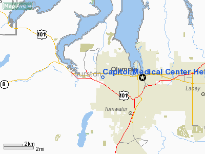
Capitol Medical Center Heliport |
Location & QuickFacts
| FAA Information Effective: | 2008-09-25 |
| Airport Identifier: | WN58 |
| Airport Status: | Operational |
| Longitude/Latitude: | 122-57-03.5100W/47-02-36.3460N
-122.950975/47.043429 (Estimated) |
| Elevation: | 200 ft / 60.96 m (Estimated) |
| Land: | 0 acres |
| From nearest city: | 2 nautical miles W of Olympia, WA |
| Location: | Thurston County, WA |
| Magnetic Variation: | 20E (1985) |
Owner & Manager
| Ownership: | Privately owned |
| Owner: | Black Hills Community Hosp. |
| Address: | 3900 Capitol Mall Drive
Olympia, WA 98502 |
| Phone number: | 206-754-5858 |
| Manager: | Ray Tiedemann, Mgr, Eng Div |
| Address: |
|
| Phone number: | 206-754-5858 |
Airport Operations and Facilities
| Airport Use: | Private
MEDICAL USE. |
| Wind indicator: | Yes |
| Segmented Circle: | No |
| Control Tower: | No |
| Sectional chart: | Seattle |
| Region: | ANM - Northwest Mountain |
| Boundary ARTCC: | ZSE - Seattle |
| Tie-in FSS: | SEA - Seattle |
| FSS Toll Free: | 1-800-WX-BRIEF |
Runway Information
Helipad H1
| Dimension: | 100 x 100 ft / 30.5 x 30.5 m |
| Surface: | CONC, |
| |
Runway H1 |
Runway |
| Traffic Pattern: | Left | Left |
|
Radio Navigation Aids
| ID |
Type |
Name |
Ch |
Freq |
Var |
Dist |
| MNC | NDB | Mason County | | 348.00 | 19E | 13.5 nm |
| GR | NDB | Graye | | 216.00 | 18E | 15.6 nm |
| LAC | NDB | Lacomas | | 328.00 | 18E | 16.3 nm |
| CAN | NDB | Carney | | 274.00 | 20E | 22.5 nm |
| PWT | NDB | Kitsap | | 206.00 | 20E | 28.1 nm |
| ODD | NDB | Dondo | | 224.00 | 19E | 32.5 nm |
| TDO | NDB | Toledo | | 219.00 | 20E | 34.6 nm |
| RNT | NDB | Renton | | 353.00 | 20E | 40.5 nm |
| OLM | VORTAC | Olympia | 081X | 113.40 | 19E | 4.8 nm |
| TCM | VORTAC | Mcchord | 033X | 109.60 | 22E | 20.5 nm |
| SEA | VORTAC | Seattle | 115X | 116.80 | 19E | 35.2 nm |
| HQM | VORTAC | Hoquiam | 124X | 117.70 | 19E | 49.5 nm |
| SEA | VOT | Seattle-tacoma | | 117.50 | | 35.7 nm |
| BFI | VOT | Boeing Field | | 108.60 | | 39.3 nm |
Remarks
- PROVIDED INGRESS/EGRESS ROUTES ARE ESTABLISHED TO AVOID HOVERING AREA.
Images and information placed above are from
http://www.airport-data.com/airport/WN58/
We thank them for the data!
| General Info
|
| Country |
United States
|
| State |
WASHINGTON
|
| FAA ID |
WN58
|
| Latitude |
47-02-36.346N
|
| Longitude |
122-57-03.510W
|
| Elevation |
200 feet
|
| Near City |
OLYMPIA
|
We don't guarantee the information is fresh and accurate. The data may
be wrong or outdated.
For more up-to-date information please refer to other sources.
|
|


