 |
|
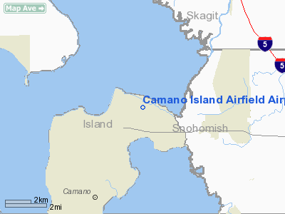
Camano Island Airfield Airport |
Location & QuickFacts
| FAA Information Effective: | 2008-09-25 |
| Airport Identifier: | 13W |
| Airport Status: | Operational |
| Longitude/Latitude: | 122-26-12.5710W/48-15-25.3590N
-122.436825/48.257044 (Estimated) |
| Elevation: | 145 ft / 44.20 m (Estimated) |
| Land: | 16 acres |
| From nearest city: | 3 nautical miles NW of Stanwood, WA |
| Location: | Island County, WA |
| Magnetic Variation: | 21E (1985) |
Owner & Manager
| Ownership: | Privately owned |
| Owner: | Steven & Norma Knopp
CO-OWNER DAN BISCHOFF |
| Address: | 1212 Moore Rd #2
Camano Island, WA 98282 |
| Phone number: | 360-629-4812 |
| Manager: | Steven & Norma Knopp |
| Address: | 1212 Moore Rd #2
Camano Island, WA 98282 |
| Phone number: | 360-629-4812 |
Airport Operations and Facilities
| Airport Use: | Open to public |
| Wind indicator: | Yes |
| Segmented Circle: | No |
| Control Tower: | No |
| Sectional chart: | Seattle |
| Region: | ANM - Northwest Mountain |
| Boundary ARTCC: | ZSE - Seattle |
| Tie-in FSS: | SEA - Seattle |
| FSS on Airport: | No |
| FSS Toll Free: | 1-800-WX-BRIEF |
| NOTAMs Facility: | SEA (NOTAM-d service avaliable) |
Airport Communications
Airport Services
| Airframe Repair: | MAJOR |
| Power Plant Repair: | MAJOR |
| Bottled Oxygen: | NONE |
| Bulk Oxygen: | NONE |
Runway Information
Runway 16/34
| Dimension: | 1750 x 24 ft / 533.4 x 7.3 m |
| Surface: | ASPH, Good Condition |
| |
Runway 16 |
Runway 34 |
| Traffic Pattern: | Right | Right |
| Obstruction: | 51 ft tree, 200.0 ft from runway, 88 ft right of centerline
15 FT TREES AT 45 FT. | 12 ft brush, 200.0 ft from runway, 22 ft right of centerline
ROAD AT 22'; 10' BRUSH AT 55'. |
|
Radio Navigation Aids
| ID |
Type |
Name |
Ch |
Freq |
Var |
Dist |
| BVS | NDB | Skagit/bay View | | 240.00 | 21E | 12.7 nm |
| OPZ | NDB | Lopez Island | | 356.00 | 21E | 23.5 nm |
| FHR | NDB | Friday Harbor | | 284.00 | 20E | 28.6 nm |
| YJ | NDB | Victoria | | 200.00 | 21E | 44.9 nm |
| XX | NDB | Abbotsford | | 344.00 | 21E | 45.6 nm |
| WC | NDB | White Rock | | 332.00 | 21E | 46.4 nm |
| RNT | NDB | Renton | | 353.00 | 20E | 46.6 nm |
| PWT | NDB | Kitsap | | 206.00 | 20E | 47.7 nm |
| LU | NDB | Cultus | | 214.00 | 22E | 48.4 nm |
| CL | NDB | Elwha | | 515.00 | 22E | 49.8 nm |
| NUW | TACAN | Whidbey Island | 085X | | 21E | 10.7 nm |
| CVV | VOR/DME | Penn Cove | 119X | 117.20 | 19E | 11.5 nm |
| PAE | VOR/DME | Paine | 043X | 110.60 | 20E | 21.3 nm |
| HUH | VORTAC | Whatcom | 077X | 113.00 | 20E | 41.8 nm |
| SEA | VORTAC | Seattle | 115X | 116.80 | 19E | 49.7 nm |
| BFI | VOT | Boeing Field | | 108.60 | | 44.2 nm |
| SEA | VOT | Seattle-tacoma | | 117.50 | | 49.2 nm |
Remarks
- STUDENT LANDINGS NOT RCMDD UNLESS ACCOMPANIED BY AN INSTRUCTOR.
- FIRST 1049 FT OF RY 16 HAS 3 % UPHILL SLOP TO THE SOUTH.
- PARALLEL DRIVEWAY ADJACENT TO RY 16/34.
- DO NOT TAXI ON GRASS OCT - MAY.
Images and information placed above are from
http://www.airport-data.com/airport/13W/
We thank them for the data!
| General Info
|
| Country |
United States
|
| State |
WASHINGTON
|
| FAA ID |
13W
|
| Latitude |
48-15-25.359N
|
| Longitude |
122-26-12.571W
|
| Elevation |
145 feet
|
| Near City |
STANWOOD
|
We don't guarantee the information is fresh and accurate. The data may
be wrong or outdated.
For more up-to-date information please refer to other sources.
|
|


