 |
|
| Bellingham International Airport |
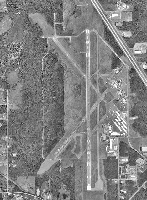 |
| 1998 USGS photo |
| IATA: BLI – ICAO: KBLI – FAA LID: BLI |
| Summary |
| Airport type |
Public |
| Operator |
Port of Bellingham |
| Location |
Whatcom County, near Bellingham, Washington |
| Elevation AMSL |
170 ft / 51.8 m |
| Coordinates |
48°47′33.9″N 122°32′15.1″W / 48.79275°N 122.537528°W / 48.79275; -122.537528Coordinates: 48°47′33.9″N 122°32′15.1″W / 48.79275°N 122.537528°W / 48.79275; -122.537528 |
| Runways |
| Direction |
Length |
Surface |
| ft |
m |
| 16/34 |
6,701 |
2,042 |
Asphalt |
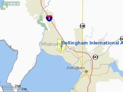
Bellingham International Airport (IATA: BLI, ICAO: KBLI, FAA LID: BLI) is a public airport located three miles (5 km) northwest of Bellingham, in Whatcom County, Washington, USA. The airport has a single runway. Due to the close proximity to British Columbia, the Bellingham International Airport functions somewhat as a reliever airport to the Vancouver International Airport. On the Allegiant Air website the airport is referred to as Bellingham/Vancouver.
In early 2007, Bellingham International hosted service to three destinations by the short-lived Western Airlines. Later the same year, Skybus Airlines provided flights to their hub in Ohio, but shut down quickly like Western Airlines had done earlier. On March 1, 2008, Allegiant Air opened up their sixth base at Bellingham International Airport. The airline currently bases two McDonnell Douglas MD-80 aircraft in Bellingham as part of the expansion. History
In 1936, Whatcom County obtained 200 acres (0.81 km) for an airport at the current airport site. Three runways were planned, but it took almost four years to get the first 5000' x 150' runway cleared and paved. Temporary Port of Entry status was secured early, but the slow construction left it in a continually tenuous state - United Airlines would only base there if the field was safe enough for their DC-3's, and it maintained its Port of Entry status. Ultimately they built a terminal, designed by F. Stanley Piper, and the airport was dedicated in 1940, having employed more than 500 people.
In 1940, the United States Army Corps of Engineers took over the facility and expanded it to three full runways, revetments for parking aircraft, and development of personnel quarters. During World War II the airport was used by Fourth Air Force immediately after the Pearl Harbor Attack for air defense of the Pacific Coast. It was later used by Air Transport Command and Air Technical Service Command as an intermediate ferrying field for Lend-Lease aircraft being flown to Alaska for subsequent transfer to the Soviet Union.
The USAAF closed the facility in September 1946, and it was turned over to the War Assets Administration for disposal. It slowly was returned to Whatcom County and was redeveloped as a civil airport in the late 1940s. Currently, only the longest of the runways (16/34) is used. The two diagonal runways have fallen into disrepair, their easternmost ends used as taxiways between tarmacs and the sole remaining runway.
In September 2010, the airport completed a $26 million resurfacing of the runway to allow aircraft up to the size of Boeing 757s to utilize the airport.
The airport is presently seeking tenders for a $30 million expansion to the terminal which will increase the size of the terminal building from 27,000 square feet (2,500 m) to 85,000 square feet (7,900 m), as well as replacing modular buildings currently at the site and adding a baggage carousel. The cost of the expansion, to be completed by 2013, accelerated from the original completion date of 2018, is covered by surcharges from passengers and parking fees.
Airlines and destinations
| Airlines |
Destinations |
| Alaska Airlines |
Honolulu [begins January 7], Las Vegas |
| Allegiant Air |
Las Vegas, Long Beach, Los Angeles, Oakland, Palm Springs [Seasonal], Phoenix/Mesa, San Diego |
| Horizon Air |
Seattle/Tacoma, Portland (OR) [seasonal] |
| San Juan Airlines |
Eastsound, Friday Harbor, Lopez, Roche Harbor |
The above content comes from Wikipedia and is published under free licenses – click here to read more.
 |
(Click on the photo to enlarge) |
Location & QuickFacts
| FAA Information Effective: | 2008-09-25 |
| Airport Identifier: | BLI |
| Airport Status: | Operational |
| Longitude/Latitude: | 122-32-15.1000W/48-47-33.7000N
-122.537528/48.792694 (Estimated) |
| Elevation: | 170 ft / 51.82 m (Surveyed) |
| Land: | 2190 acres |
| From nearest city: | 3 nautical miles NW of Bellingham, WA |
| Location: | Whatcom County, WA |
| Magnetic Variation: | 20E (1995) |
Owner & Manager
| Ownership: | Publicly owned |
| Owner: | Port Of Bellingham |
| Address: | 1801 Roeder Ave
Bellingham, WA 98227 |
| Phone number: | 360-676-2500 |
| Manager: | Art Choat
AIRPORT DIRECTOR |
| Address: | 4255 Mitchell Way Ste 206
Bellingham, WA 98226 |
| Phone number: | 360-671-5674 |
Airport Operations and Facilities
| Airport Use: | Open to public |
| Wind indicator: | Yes |
| Segmented Circle: | Yes |
| Control Tower: | Yes |
| Lighting Schedule: | DUSK-DAWN
WHEN TWR CLSD ACTIVATE HIRL RY 16-34, MALSR RY 16, REIL RY 34 - CTAF. |
| Beacon Color: | Clear-Green (lighted land airport) |
| Landing fee charge: | Yes
OVER 7500 LBS. |
| Sectional chart: | Seattle |
| Region: | ANM - Northwest Mountain |
| Traffic Pattern Alt: | 1030 ft |
| Boundary ARTCC: | ZSE - Seattle |
| Responsible ARTCC: | ZVR - Vancouver |
| Tie-in FSS: | SEA - Seattle |
| FSS Toll Free: | 1-800-WX-BRIEF |
| NOTAMs Facility: | BLI (NOTAM-d service avaliable) |
| Certification type/date: | I B S 11/1974
PPR FOR UNSKED ACR OPNS WITH MORE THAN 30 PSGR SEATS CALL AMGR 360-671-5674. |
| Federal Agreements: | NGPRY3 |
Airport Communications
| CTAF: | 124.900 |
| Unicom: | 122.950 |
Airport Services
| Fuel available: | 100LLA |
| Airframe Repair: | NONE |
| Power Plant Repair: | MAJOR |
| Bottled Oxygen: | HIGH/LOW |
| Bulk Oxygen: | NONE |
Runway Information
Runway 16/34
| Dimension: | 6701 x 150 ft / 2042.5 x 45.7 m |
| Surface: | ASPH, Fair Condition |
| Surface Treatment: | Aggregate Friction Seal Coat
GROOVED AFSC. |
| Weight Limit: | Single wheel: 75000 lbs.
Dual wheel: 160000 lbs.
Dual tandem wheel: 250000 lbs. |
| Edge Lights: | High |
| |
Runway 16 |
Runway 34 |
| Longitude: | 122-32-15.1993W | 122-32-14.9321W |
| Latitude: | 48-48-06.7495N | 48-47-00.6325N |
| Elevation: | 162.00 ft | 170.00 ft |
| Alignment: | 127 | 127 |
| ILS Type: | ILS/DME
| MLS |
| Traffic Pattern: | Right | Left |
| Markings: | Precision instrument, Good Condition | Precision instrument, Good Condition |
| Crossing Height: | 50.00 ft | 50.00 ft |
| VASI: | 4-light PAPI on left side | 4-box on left side |
| Visual Glide Angle: | 3.00° | 3.00° |
| RVR Equipment: | touchdown | |
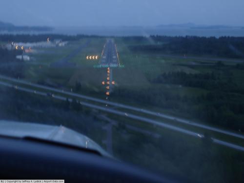
| Approach lights: | MALSR | |
| Runway End Identifier: | | Yes |
| Obstruction: | , 50:1 slope to clear | 54 ft tree, 1400.0 ft from runway, 100 ft left of centerline, 22:1 slope to clear |
|
Radio Navigation Aids
| ID |
Type |
Name |
Ch |
Freq |
Var |
Dist |
| XX | NDB | Abbotsford | | 344.00 | 21E | 13.5 nm |
| WC | NDB | White Rock | | 332.00 | 21E | 14.8 nm |
| BVS | NDB | Skagit/bay View | | 240.00 | 21E | 20.0 nm |
| LU | NDB | Cultus | | 214.00 | 22E | 23.7 nm |
| OPZ | NDB | Lopez Island | | 356.00 | 21E | 24.2 nm |
| FHR | NDB | Friday Harbor | | 284.00 | 20E | 25.2 nm |
| AP | NDB | Active Pass | | 378.00 | 21E | 30.2 nm |
| VR | NDB | Vancouver | | 266.00 | 21E | 30.7 nm |
| YJ | NDB | Victoria | | 200.00 | 21E | 35.3 nm |
| V | NDB | Victor | | 368.00 | 22E | 36.0 nm |
| MB | NDB | Mill Bay | | 293.00 | 21E | 40.3 nm |
| NUW | TACAN | Whidbey Island | 085X | | 21E | 26.8 nm |
| CVV | VOR/DME | Penn Cove | 119X | 117.20 | 19E | 33.8 nm |
| YYJ | VOR/DME | Victoria | 084X | 113.70 | 21E | 37.7 nm |
| HUH | VORTAC | Whatcom | 077X | 113.00 | 20E | 9.3 nm |
| YVR | VORTAC | Vancouver | 44 | 115.90 | 21E | 29.6 nm |
Remarks
- BIRDS ON & INVOF ARPT.
- COMMERCIAL RAMP CLSD TO PVT ACFT.
- ATCT SVC NOT AVBL AT TWY A INVOF TWY G; THE SOUTH HOLD AREA & THE RUNUP AREA DUE TO OBSTRUCTED VISION.
- NOISE ABATEMENT PROCEDURES IN EFFECT CTC AMGR AT 360-671-5674.
- TWY "J", TWY "F" FM TWY "A" EASTWARD TO TWY "D", AND TWY "D" FM TWY "E" TO TWY "F" CLOSED TO AIR CARRIER OPERATIONS.
- TWY "C" FM RY 16/34 TO TWY "A"ONLY 40 FT WIDE.
- ESTABD PRIOR TO 1959.
Images and information placed above are from
http://www.airport-data.com/airport/BLI/
We thank them for the data!
| General Info
|
| Country |
United States
|
| State |
WASHINGTON
|
| FAA ID |
BLI
|
| Latitude |
48-47-33.900N
|
| Longitude |
122-32-15.100W
|
| Elevation |
170 feet
|
| Near City |
BELLINGHAM
|
We don't guarantee the information is fresh and accurate. The data may
be wrong or outdated.
For more up-to-date information please refer to other sources.
|
|


