 |
|
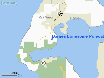
Barnes Lonesome Polecat Ranch Heliport |
Location & QuickFacts
| FAA Information Effective: | 2008-09-25 |
| Airport Identifier: | 3WA5 |
| Airport Status: | Operational |
| Longitude/Latitude: | 122-40-00.0000W/48-15-30.0000N
-122.666667/48.258333 (Estimated) |
| Elevation: | 188 ft / 57.30 m (Estimated) |
| Land: | 21 acres |
| From nearest city: | 3 nautical miles S of Oak Harbor, WA |
| Location: | Island County, WA |
| Magnetic Variation: | 20E (1995) |
Owner & Manager
| Ownership: | Privately owned |
| Owner: | Brooke Barnes |
| Address: | 1000 Balda Road
Oak Harbor, WA 98277 |
| Phone number: | 206-283-4000 |
| Manager: | Brooke Barnes |
| Address: | 1000 Balda Road
Oak Harbor, WA 98277 |
| Phone number: | 206-283-4000 |
Airport Operations and Facilities
| Airport Use: | Private |
| Wind indicator: | Yes |
| Segmented Circle: | No |
| Control Tower: | No |
| Sectional chart: | Seattle |
| Region: | ANM - Northwest Mountain |
| Boundary ARTCC: | ZSE - Seattle |
| Tie-in FSS: | SEA - Seattle |
| FSS on Airport: | No |
| FSS Toll Free: | 1-800-WX-BRIEF |
Runway Information
Runway 07/25
| Dimension: | 500 x 125 ft / 152.4 x 38.1 m |
| Surface: | GRVL-TURF, |
| |
Runway 07 |
Runway 25 |
| Traffic Pattern: | Left | Right |
|
Radio Navigation Aids
| ID |
Type |
Name |
Ch |
Freq |
Var |
Dist |
| BVS | NDB | Skagit/bay View | | 240.00 | 21E | 16.1 nm |
| OPZ | NDB | Lopez Island | | 356.00 | 21E | 16.7 nm |
| FHR | NDB | Friday Harbor | | 284.00 | 20E | 21.6 nm |
| YJ | NDB | Victoria | | 200.00 | 21E | 37.3 nm |
| CL | NDB | Elwha | | 515.00 | 22E | 40.7 nm |
| MB | NDB | Mill Bay | | 293.00 | 21E | 42.6 nm |
| AP | NDB | Active Pass | | 378.00 | 21E | 44.5 nm |
| WC | NDB | White Rock | | 332.00 | 21E | 44.8 nm |
| XX | NDB | Abbotsford | | 344.00 | 21E | 46.1 nm |
| PWT | NDB | Kitsap | | 206.00 | 20E | 46.2 nm |
| RNT | NDB | Renton | | 353.00 | 20E | 49.3 nm |
| NUW | TACAN | Whidbey Island | 085X | | 21E | 5.8 nm |
| CVV | VOR/DME | Penn Cove | 119X | 117.20 | 19E | 2.5 nm |
| PAE | VOR/DME | Paine | 043X | 110.60 | 20E | 25.6 nm |
| YYJ | VOR/DME | Victoria | 084X | 113.70 | 21E | 43.1 nm |
| HUH | VORTAC | Whatcom | 077X | 113.00 | 20E | 41.4 nm |
| BFI | VOT | Boeing Field | | 108.60 | | 46.3 nm |
Images and information placed above are from
http://www.airport-data.com/airport/3WA5/
We thank them for the data!
| General Info
|
| Country |
United States
|
| State |
WASHINGTON
|
| FAA ID |
3WA5
|
| Latitude |
48-15-30.000N
|
| Longitude |
122-40-00.000W
|
| Elevation |
188 feet
|
| Near City |
OAK HARBOR
|
We don't guarantee the information is fresh and accurate. The data may
be wrong or outdated.
For more up-to-date information please refer to other sources.
|
|


