 |
|
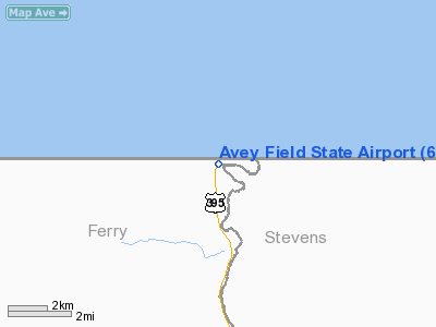
Avey Field State Airport
Avey Field State/Laurier Airport |
| IATA: none – ICAO: none – FAA LID: 69S |
| Summary |
| Airport type |
Public |
| Owner |
WSDOT Aviation Division |
| Operator |
Washington State |
| Serves |
Laurier, Washington |
| Location |
Canada-United States border |
| Elevation AMSL |
1,655 ft / 504 m |
| Coordinates |
48°59′54″N 118°13′22″W / 48.99833°N 118.22278°W / 48.99833; -118.22278 (Avey Field State Airport) |
| Runways |
| Direction |
Length |
Surface |
| ft |
m |
17/35
16/34 |
1,975
2,000 |
602
610 |
Gravel |
| Statistics |
| Aircraft operations |
800 |
| Sources: Federal Aviation Administration and Canada Flight Supplement |
Avey Field State Airport (FAA LID: 69S) is a public use airport located on the border at Laurier, in Ferry County, Washington, United States. It is owned by the Washington State DOT Aviation Division.
Also known as Avey Field State/Laurier Airport, it is one of three airports that straddle the United States and Canadian border (the other two are Piney Pinecreek Border Airport and Coronach/Scobey Border Station Airport). The airport is shared by the State of Washington and the Province of British Columbia. Both the United States Customs Service and Canada Border Services Agency have offices conveniently located on U.S. Route 395 and British Columbia Highway 395 adjacent to the parking area. Laurier consists of the customs office and a post office. Little remains to indicate the thriving mining community of the 1890s. The nearest motels and recreational sites are located in Canada at a distance of 4 miles.
The Canadian recreational community of Christina Lake is 6.5 km (4.0 mi) north along Highway 395 and the Crowsnest Highway/Highway 3, while Orient, Washington, is approximately 10 mi (16 km) south along U.S. Route 395.
Facilities and aircraft
The unattended airport is at an elevation of 1,655 ft (504 m) above mean sea level and covers 10 acres (4 ha). The gravel runway 17-35 measures 1,975 by 40 feet (602 x 12 m). It is marked with retro-reflective devices, but both shoulders are soft and rough.
Mountains and hills surround the airport and there are trees on both approaches. An overflight to verify field conditions and to rule out obstructions (such as pedestrians, vehicles or animals) is recommended. The field is usually open from June 1 to October 1.
For the 12-month period ending December 31, 2006, the airport had 800 general aviation aircraft operations, an average of 66 per month.
The above content comes from Wikipedia and is published under free licenses – click here to read more.
Location & QuickFacts
| FAA Information Effective: | 2008-09-25 |
| Airport Identifier: | 69S |
| Airport Status: | Operational |
| Longitude/Latitude: | 118-13-21.3550W/48-59-54.1660N
-118.222599/48.998379 (Estimated) |
| Elevation: | 1655 ft / 504.44 m (Estimated) |
| Land: | 10 acres |
| From nearest city: | 2 nautical miles SW of Laurier, WA |
| Location: | Ferry County, WA |
| Magnetic Variation: | 20E (1985) |
Owner & Manager
| Ownership: | Publicly owned |
| Owner: | Wash State Aviation Div |
| Address: | 3704 172nd St Ne, Suite K2, Po Box 3367
Arlington, WA 98223-6336 |
| Phone number: | 360-651-6300 |
| Manager: | Jim Scott |
| Address: | 3704 172nd St Ne, Suite K2, Po Box 3367
Arlington, WA 98223-6336 |
| Phone number: | 360-651-6300 |
Airport Operations and Facilities
| Airport Use: | Open to public |
| Wind indicator: | Yes |
| Segmented Circle: | No |
| Control Tower: | No |
| Landing fee charge: | No |
| Sectional chart: | Seattle |
| Region: | ANM - Northwest Mountain |
| Boundary ARTCC: | ZSE - Seattle |
| Tie-in FSS: | SEA - Seattle |
| FSS on Airport: | No |
| FSS Toll Free: | 1-800-WX-BRIEF |
| NOTAMs Facility: | SEA (NOTAM-d service avaliable) |
Airport Communications
Airport Services
| Airframe Repair: | NONE |
| Power Plant Repair: | NONE |
Runway Information
Runway 17/35
| Dimension: | 1975 x 40 ft / 602.0 x 12.2 m |
| Surface: | GRVL, Fair Condition |
| |
Runway 17 |
Runway 35 |
| Longitude: | 118-13-20.1090W | 118-13-22.6010W |
| Latitude: | 49-00-03.8740N | 48-59-44.4590N |
| Alignment: | 127 | 5 |
| Traffic Pattern: | Left | Left |
| Obstruction: | 30 ft trees, 1.0 ft from runway | 30 ft trees, 1.0 ft from runway |
|
Radio Navigation Aids
| ID |
Type |
Name |
Ch |
Freq |
Var |
Dist |
| EF | NDB | Champion | | 206.00 | 20E | 27.8 nm |
| YK | NDB | Brilliant | | 269.00 | 20E | 30.4 nm |
| ION | NDB | Ione | | 379.00 | 21E | 36.4 nm |
| CG | NDB | Castlegar | | 227.00 | 20E | 37.1 nm |
Remarks
- ARPT CLSD YEARLY 1 OCT-1 JUN.
- VEHICLES; PEDESTRIANS & ANIMALS ON & INVOF RY.
- CTC WASHINGTON STATE AVIATION DIVISION 360-651-6300 OR 1-800-552-0666 FOR FACILITY INFORMATION PRIOR TO USE.
- SHOULDERS VERY SOFT AND ROUGH BOTH SIDES OF RY.
- DENSITY ALTITUDE.
- CANADIAN AND U.S. CUSTOMS AVAILABLE ON HWY TO THE WEST.
- UNITED STATES BASED AIRCRAFT SHOULD PARK ON U.S. SIDE OF RAMP (SOUTH) AND CANADIAN BASED AIRCRAFT SHOULD PARK ON NORTH SIDE OF RAMP.
Images and information placed above are from
http://www.airport-data.com/airport/69S/
We thank them for the data!
| General Info
|
| Country |
United States
|
| State |
WASHINGTON
|
| FAA ID |
69S
|
| Latitude |
48-59-59.655N
|
| Longitude |
118-13-31.042W
|
| Elevation |
1655 feet
|
| Near City |
LAURIER
|
We don't guarantee the information is fresh and accurate. The data may
be wrong or outdated.
For more up-to-date information please refer to other sources.
|
|


