 |
|
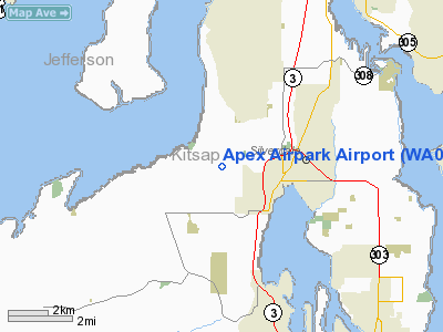
Location & QuickFacts
| FAA Information Effective: | 2008-09-25 |
| Airport Identifier: | WA05 |
| Airport Status: | Operational |
| Longitude/Latitude: | 122-43-59.5430W/47-39-24.3360N
-122.733206/47.656760 (Estimated) |
| Elevation: | 525 ft / 160.02 m (Estimated) |
| Land: | 16 acres |
| From nearest city: | 2 nautical miles NW of Silverdale, WA |
| Location: | Kitsap County, WA |
| Magnetic Variation: | 21E (1975) |
Owner & Manager
| Ownership: | Privately owned |
| Owner: | Apex Property Owners, Inc. |
| Address: | Po Box 1659
Silverdale, WA 98383 |
| Phone number: | 360-307-9160
OR 360-692-1392. |
| Manager: | Bill Swope |
| Address: | 10670 Contact Court
Silverdale, WA 98383 |
| Phone number: | 360-698-7127 |
Airport Operations and Facilities
| Airport Use: | Private |
| Wind indicator: | Yes |
| Segmented Circle: | Yes |
| Control Tower: | No |
| Lighting Schedule: | DUSK-DAWN |
| Beacon Color: | Clear (unlighted land airport) |
| Landing fee charge: | No |
| Sectional chart: | Seattle |
| Region: | ANM - Northwest Mountain |
| Boundary ARTCC: | ZSE - Seattle |
| Tie-in FSS: | SEA - Seattle |
| FSS on Airport: | No |
| FSS Toll Free: | 1-800-WX-BRIEF |
Airport Communications
Airport Services
| Airframe Repair: | MAJOR |
| Power Plant Repair: | MAJOR |
| Bottled Oxygen: | NONE |
| Bulk Oxygen: | NONE |
Runway Information
Runway 17/35
| Dimension: | 2500 x 28 ft / 762.0 x 8.5 m |
| Surface: | ASPH, |
| Edge Lights: | Low |
| |
Runway 17 |
Runway 35 |
| Traffic Pattern: | Left | Right |
| Markings: | Basic, Good Condition
ARPT NAME & SEGEMENTED CIRCLE PAINTED ON RWY AT MIDFIELD. | Basic, Good Condition |
| Runway End Identifier: | No | No |
| Centerline Lights: | No | No |
| Touchdown Lights: | No | No |
| Obstruction: | 50 ft trees, 200.0 ft from runway, 44 ft right of centerline
+3' FENCE 26 RIGHT AT 60', +35' TREE 44R AT 100', 15' BRUSH 67L AT 75'. | 3 ft fence, 200.0 ft from runway, 40 ft right of centerline
+4' SIGN 66R AT 60', +10-+70' BRUSH & TREES 100-125'R FROM THR TO 200'. |
|
Radio Navigation Aids
| ID |
Type |
Name |
Ch |
Freq |
Var |
Dist |
| PWT | NDB | Kitsap | | 206.00 | 20E | 9.9 nm |
| CAN | NDB | Carney | | 274.00 | 20E | 15.4 nm |
| RNT | NDB | Renton | | 353.00 | 20E | 23.2 nm |
| ODD | NDB | Dondo | | 224.00 | 19E | 24.6 nm |
| MNC | NDB | Mason County | | 348.00 | 19E | 28.4 nm |
| GR | NDB | Graye | | 216.00 | 18E | 30.9 nm |
| LAC | NDB | Lacomas | | 328.00 | 18E | 39.7 nm |
| CL | NDB | Elwha | | 515.00 | 22E | 48.0 nm |
| NUW | TACAN | Whidbey Island | 085X | | 21E | 42.1 nm |
| PAE | VOR/DME | Paine | 043X | 110.60 | 20E | 24.3 nm |
| CVV | VOR/DME | Penn Cove | 119X | 117.20 | 19E | 35.3 nm |
| SEA | VORTAC | Seattle | 115X | 116.80 | 19E | 21.7 nm |
| TCM | VORTAC | Mcchord | 033X | 109.60 | 22E | 32.4 nm |
| OLM | VORTAC | Olympia | 081X | 113.40 | 19E | 41.8 nm |
| BFI | VOT | Boeing Field | | 108.60 | | 19.1 nm |
| SEA | VOT | Seattle-tacoma | | 117.50 | | 21.7 nm |
Remarks
- TWY EAST SIDE RWY.
- NO LINE OF SIGHT BTN RWY ENDS.
- ACFT PARKED IN PRIM SFC.
- TREES, ACFT AND BDLGS IN TRANSITION SFCS.
- CTN: CHILDREN AND PETS ETC. ON INVOF ARPT.
- USE CAUTION ON TXY
Images and information placed above are from
http://www.airport-data.com/airport/WA05/
We thank them for the data!
| General Info
|
| Country |
United States
|
| State |
WASHINGTON
|
| FAA ID |
WA05
|
| Latitude |
47-39-24.336N
|
| Longitude |
122-43-59.543W
|
| Elevation |
525 feet
|
| Near City |
SILVERDALE
|
We don't guarantee the information is fresh and accurate. The data may
be wrong or outdated.
For more up-to-date information please refer to other sources.
|
|


