|
|
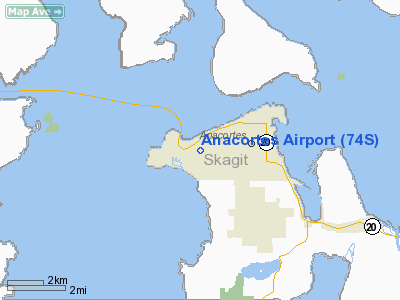
| Anacortes Airport |
 |
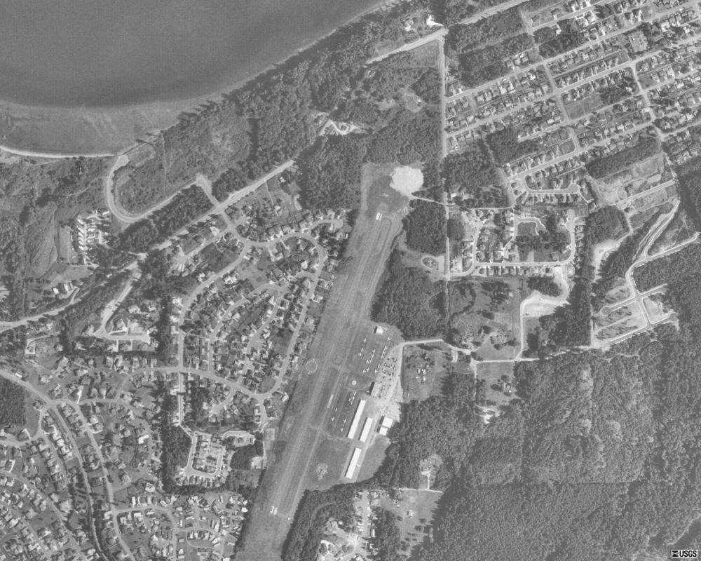
| USGS aerial image as of 21 July 1998 |
| IATA: OTS – ICAO: none – FAA LID: 74S |
| Summary |
| Airport type |
Public |
| Owner |
Port of Anacortes |
| Serves |
Anacortes, Washington |
| Elevation AMSL |
241 ft / 73 m |
| Coordinates |
48°29′56″N 122°39′45″W / 48.49889°N 122.6625°W / 48.49889; -122.6625 |
| Website |
PortOfAnacortes.com/... |
| Runways |
| Direction |
Length |
Surface |
| ft |
m |
| 18/36 |
3,015 |
919 |
Asphalt |
| Statistics (2008) |
| Aircraft operations |
14,500 |
| Based aircraft |
43 |
| Source: Federal Aviation Administration |
Anacortes Airport (IATA: OTS, FAA LID: 74S) is a public use airport located two nautical miles (3.7 km) west of the central business district of Anacortes, a city in Skagit County, Washington, United States. It is owned by the Port of Anacortes. Facilities and aircraft
Anacortes Airport covers an area of 120 acres (49 ha) at an elevation of 241 feet (73 m) above mean sea level. It has one runway designated 18/36 with an asphalt surface measuring 3,015 by 60 feet (919 x 18 m).
For the 12-month period ending May 30, 2008, the airport had 14,500 aircraft operations, an average of 39 per day: 79% general aviation and 21% air taxi. At that time there were 43 aircraft based at this airport: 95% single-engine and 5% multi-engine.
Airline and destinations
| Airlines |
Destinations |
| San Juan Airlines |
Eastsound, Friday Harbor, Lopez, Roche Harbor |
The above content comes from Wikipedia and is published under free licenses – click here to read more.
Location & QuickFacts
| FAA Information Effective: | 2008-09-25 |
| Airport Identifier: | 74S |
| Airport Status: | Operational |
| Longitude/Latitude: | 122-39-44.6240W/48-29-56.3730N
-122.662396/48.498992 (Estimated) |
| Elevation: | 241 ft / 73.46 m (Surveyed) |
| Land: | 120 acres |
| From nearest city: | 2 nautical miles W of Anacortes, WA |
| Location: | Skagit County, WA |
| Magnetic Variation: | 21E (1985) |
Owner & Manager
| Ownership: | Publicly owned |
| Owner: | Port Of Anacortes |
| Address: | Box 297
Anacortes, WA 98221 |
| Phone number: | 360-293-3134 |
| Manager: | John Hachey |
| Address: | Box 297
Anacortes, WA 98221 |
| Phone number: | 360-293-3134 |
Airport Operations and Facilities
| Airport Use: | Open to public |
| Wind indicator: | Yes |
| Segmented Circle: | Yes |
| Control Tower: | No |
| Lighting Schedule: | DUSK-DAWN
ACTVT MIRL & REILS RY 18/36 - CTAF. |
| Beacon Color: | Clear-Green (lighted land airport) |
| Landing fee charge: | No |
| Sectional chart: | Seattle |
| Region: | ANM - Northwest Mountain |
| Boundary ARTCC: | ZSE - Seattle |
| Tie-in FSS: | SEA - Seattle |
| FSS on Airport: | No |
| FSS Toll Free: | 1-800-WX-BRIEF |
| NOTAMs Facility: | SEA (NOTAM-d service avaliable) |
| Federal Agreements: | NGY |
Airport Communications
Airport Services
| Fuel available: | 100 A |
| Airframe Repair: | MAJOR |
| Power Plant Repair: | MAJOR |
| Bottled Oxygen: | NONE |
| Bulk Oxygen: | NONE |
Runway Information
Runway 18/36
| Dimension: | 3015 x 60 ft / 919.0 x 18.3 m |
| Surface: | ASPH, Good Condition |
| Surface Treatment: | Saw-cut or plastic Grooved |
| Weight Limit: | Single wheel: 12500 lbs. |
| Edge Lights: | Medium |
| |
Runway 18 |
Runway 36 |
| Traffic Pattern: | Right | Left |
| Markings: | Basic, Good Condition | Basic, Good Condition |
| Crossing Height: | 40.00 ft | 40.00 ft |
| VASI: | 4-light PAPI on right side | 4-light PAPI on left side |
| Visual Glide Angle: | 3.00° | 3.00° |
| Runway End Identifier: | Yes | Yes |
| Obstruction: | 47 ft trees, 1350.0 ft from runway, 24:1 slope to clear | 20 ft trees, 1158.0 ft from runway, 46:1 slope to clear |
|
Radio Navigation Aids
| ID |
Type |
Name |
Ch |
Freq |
Var |
Dist |
| BVS | NDB | Skagit/bay View | | 240.00 | 21E | 9.9 nm |
| OPZ | NDB | Lopez Island | | 356.00 | 21E | 10.4 nm |
| FHR | NDB | Friday Harbor | | 284.00 | 20E | 14.7 nm |
| WC | NDB | White Rock | | 332.00 | 21E | 30.4 nm |
| YJ | NDB | Victoria | | 200.00 | 21E | 30.6 nm |
| XX | NDB | Abbotsford | | 344.00 | 21E | 31.8 nm |
| AP | NDB | Active Pass | | 378.00 | 21E | 33.6 nm |
| MB | NDB | Mill Bay | | 293.00 | 21E | 36.3 nm |
| LU | NDB | Cultus | | 214.00 | 22E | 39.7 nm |
| VR | NDB | Vancouver | | 266.00 | 21E | 43.4 nm |
| CL | NDB | Elwha | | 515.00 | 22E | 45.4 nm |
| V | NDB | Victor | | 368.00 | 22E | 47.1 nm |
| NUW | TACAN | Whidbey Island | 085X | | 21E | 8.7 nm |
| CVV | VOR/DME | Penn Cove | 119X | 117.20 | 19E | 15.5 nm |
| YYJ | VOR/DME | Victoria | 084X | 113.70 | 21E | 35.4 nm |
| PAE | VOR/DME | Paine | 043X | 110.60 | 20E | 38.1 nm |
| HUH | VORTAC | Whatcom | 077X | 113.00 | 20E | 27.0 nm |
| YVR | VORTAC | Vancouver | 44 | 115.90 | 21E | 39.7 nm |
Remarks
- MILITARY ARRIVAL CORRIDOR N & W OF ARPT.
- RWY 36 PREFERRED CALM WIND RY.
- NOISE ABATEMENT PROCEDURES IN EFFECT; CTC AMGR 360-293-3134.
- NO TOUCH & GO LDGS.
Images and information placed above are from
http://www.airport-data.com/airport/74S/
We thank them for the data!
| General Info
|
| Country |
United States
|
| State |
WASHINGTON
|
| FAA ID |
74S
|
| Latitude |
48-29-56.373N
|
| Longitude |
122-39-44.624W
|
| Elevation |
241 feet
|
| Near City |
ANACORTES
|
We don't guarantee the information is fresh and accurate. The data may
be wrong or outdated.
For more up-to-date information please refer to other sources.
|
|