 |
|
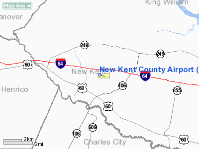
Location & QuickFacts
| FAA Information Effective: | 2008-09-25 |
| Airport Identifier: | W96 |
| Airport Status: | Operational |
| Longitude/Latitude: | 077-07-31.8970W/37-30-11.5250N
-77.125527/37.503201 (Estimated) |
| Elevation: | 123 ft / 37.49 m (Estimated) |
| Land: | 150 acres |
| From nearest city: | 8 nautical miles W of Quinton, VA |
| Location: | New Kent County, VA |
| Magnetic Variation: | 10W (2005) |
Owner & Manager
| Ownership: | Publicly owned |
| Owner: | County Of New Kent |
| Address: | 6901 Terminal Rd
New Kent, VA 23124-0050 |
| Phone number: | 804-932-3984 |
| Manager: | William (bill) Kelly |
| Address: | 6901 Terminal Rd
Quinton, VA 23141-2427 |
| Phone number: | 804-932-3984 |
Airport Operations and Facilities
| Airport Use: | Open to public |
| Wind indicator: | Yes |
| Segmented Circle: | Yes |
| Control Tower: | No |
| Lighting Schedule: | DUSK-DAWN
MIRL & REIL RY 10 & 28 PRESET LOW INTST; TO INCR INTST ACTVT - CTAF. |
| Beacon Color: | Clear-Green (lighted land airport)
ROTG BCN NOT VISIBLE WHEN APPROACHING FM THE NORTH. |
| Landing fee charge: | No |
| Sectional chart: | Washington |
| Region: | AEA - Eastern |
| Traffic Pattern Alt: | 800 ft |
| Boundary ARTCC: | ZDC - Washington |
| Tie-in FSS: | DCA - Leesburg |
| FSS on Airport: | No |
| FSS Toll Free: | 1-800-WX-BRIEF |
| NOTAMs Facility: | DCA (NOTAM-d service avaliable) |
| Federal Agreements: | NGY |
Airport Communications
| CTAF: | 122.800 |
| Unicom: | 122.800 |
Airport Services
| Fuel available: | 100LL
FUEL AVBL 24 HRS, CREDIT CARD REQUIRED WHEN UNATENDED. |
| Bottled Oxygen: | NONE |
| Bulk Oxygen: | NONE |
Runway Information
Runway 10/28
| Dimension: | 3600 x 75 ft / 1097.3 x 22.9 m |
| Surface: | ASPH, Good Condition |
| Weight Limit: | Single wheel: 12500 lbs. |
| Edge Lights: | Medium |
| |
Runway 10 |
Runway 28 |
| Longitude: | 077-07-53.9000W | 077-07-09.9000W |
| Latitude: | 37-30-15.5300N | 37-30-09.5300N |
| Elevation: | 123.00 ft | 123.00 ft |
| Alignment: | 100 | 127 |
| Traffic Pattern: | Left | Left |
| Markings: | Non-precision instrument, Good Condition | Non-precision instrument, Good Condition |
| Crossing Height: | 45.00 ft | 45.00 ft |
| VASI: | 2-light PAPI on right side | 2-light PAPI on left side |
| Visual Glide Angle: | 4.00° | 4.00° |
| Runway End Identifier: | Yes | Yes |
| Obstruction: | 18 ft tree, 399.0 ft from runway, 130 ft left of centerline, 11:1 slope to clear | 15 ft tree, 390.0 ft from runway, 110 ft left of centerline, 12:1 slope to clear |
|
Radio Navigation Aids
| ID |
Type |
Name |
Ch |
Freq |
Var |
Dist |
| CF | NDB | Pubbs | | 392.00 | 09W | 18.7 nm |
| LJK | NDB | Ashey | | 280.00 | 09W | 23.4 nm |
| PTB | NDB | Petersburg | | 284.00 | 08W | 31.0 nm |
| AKQ | NDB | Wakefield | | 274.00 | 09W | 31.8 nm |
| FAF | NDB | Felker | | 226.00 | 08W | 32.7 nm |
| APH | NDB | A P Hill | | 396.00 | 10W | 36.4 nm |
| PJS | NDB | Henry | | 375.00 | 09W | 37.5 nm |
| IQK | NDB | Louisa | | 382.00 | 09W | 46.7 nm |
| EZF | NDB | Shannon | | 237.00 | 10W | 48.4 nm |
| BKT | NDB | Blackstone | | 326.00 | 09W | 49.4 nm |
| LFI | TACAN | Langley | 070X | | 10W | 44.4 nm |
| RIC | VORTAC | Richmond | 088X | 114.10 | 09W | 9.3 nm |
| HPW | VORTAC | Hopewell | 057X | 112.00 | 06W | 10.5 nm |
| HCM | VORTAC | Harcum | 025X | 108.80 | 07W | 20.0 nm |
| FAK | VORTAC | Flat Rock | 080X | 113.30 | 06W | 33.5 nm |
| FKN | VORTAC | Franklin | 043X | 110.60 | 09W | 47.7 nm |
Remarks
- DEER ON & INVOF ARPT.
- ULTRALIGHT ACTIVITY ON & INVOF ARPT.
- GCO AVL ON FREQ 135.075 THRU PCT CLEARANCE DELIVERY.
Images and information placed above are from
http://www.airport-data.com/airport/W96/
We thank them for the data!
| General Info
|
| Country |
United States
|
| State |
VIRGINIA
|
| FAA ID |
W96
|
| Latitude |
37-30-11.525N
|
| Longitude |
077-07-31.897W
|
| Elevation |
123 feet
|
| Near City |
QUINTON
|
We don't guarantee the information is fresh and accurate. The data may
be wrong or outdated.
For more up-to-date information please refer to other sources.
|
|


