 |
|
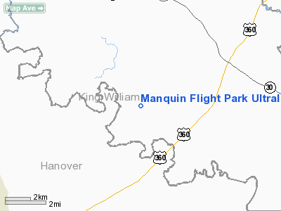
Manquin Flight Park Ultralight Airport |
Location & QuickFacts
| FAA Information Effective: | 2008-09-25 |
| Airport Identifier: | 04VG |
| Airport Status: | Operational |
| Longitude/Latitude: | 077-12-42.5400W/37-42-51.9600N
-77.211817/37.714433 (Estimated) |
| Elevation: | 50 ft / 15.24 m (Estimated) |
| Land: | 180 acres |
| From nearest city: | 4 nautical miles N of Manquin, VA |
| Location: | Washington County, VA |
| Magnetic Variation: | () |
Owner & Manager
| Ownership: | Privately owned |
| Owner: | Manquin Flight Park Inc |
| Address: | P. O. Box 159
Manquin, VA 23106 |
| Phone number: | 804-514-5843 |
| Manager: | Rawling G. Davenport Jr. |
| Address: | P. O. Box 159
Manquin, VA 23106 |
| Phone number: | 804-514-5843 |
Airport Operations and Facilities
| Airport Use: | Private |
| Wind indicator: | Yes |
| Segmented Circle: | No |
| Control Tower: | No |
| Sectional chart: | Washington |
| Region: | AEA - Eastern |
| Boundary ARTCC: | ZTL - Atlanta |
| Tie-in FSS: | DCA - Leesburg |
| FSS Toll Free: | 1-800-WX-BRIEF |
Runway Information
Runway 01/19
| Dimension: | 3500 x 80 ft / 1066.8 x 24.4 m |
| Surface: | TURF, Fair Condition |
| |
Runway 01 |
Runway 19 |
| Traffic Pattern: | Left | Left |
|
Runway 11/29
| Dimension: | 1800 x 70 ft / 548.6 x 21.3 m |
| Surface: | TURF, Fair Condition |
| |
Runway 11 |
Runway 29 |
| Traffic Pattern: | Left | Left |
|
Radio Navigation Aids
| ID |
Type |
Name |
Ch |
Freq |
Var |
Dist |
| LJK | NDB | Ashey | | 280.00 | 09W | 13.2 nm |
| APH | NDB | A P Hill | | 396.00 | 10W | 23.1 nm |
| CF | NDB | Pubbs | | 392.00 | 09W | 25.6 nm |
| EZF | NDB | Shannon | | 237.00 | 10W | 35.1 nm |
| IQK | NDB | Louisa | | 382.00 | 09W | 35.8 nm |
| PTB | NDB | Petersburg | | 284.00 | 08W | 39.2 nm |
| FAF | NDB | Felker | | 226.00 | 08W | 44.7 nm |
| AKQ | NDB | Wakefield | | 274.00 | 09W | 45.1 nm |
| PJS | NDB | Henry | | 375.00 | 09W | 49.0 nm |
| RIC | VORTAC | Richmond | 088X | 114.10 | 09W | 13.8 nm |
| HPW | VORTAC | Hopewell | 057X | 112.00 | 06W | 23.6 nm |
| HCM | VORTAC | Harcum | 025X | 108.80 | 07W | 28.7 nm |
| FAK | VORTAC | Flat Rock | 080X | 113.30 | 06W | 31.4 nm |
| BRV | VORTAC | Brooke | 092X | 114.50 | 09W | 38.0 nm |
| GVE | VORTAC | Gordonsville | 103X | 115.60 | 06W | 48.1 nm |
Remarks
- PROVIDED DALGT VFR ONLY, CLEAR 20:1 APCH, LOW FLYING ACFT SIGNS NEAR ENTRANCE & LOW ROAD/RY ACCESS, MARKER BALLS ON PLINES IF PRESENT, COO-ORD W/ HUNT 4 NM EAST.
Images and information placed above are from
http://www.airport-data.com/airport/04VG/
We thank them for the data!
|
|


