 |
|
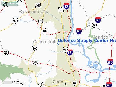
Defense Supply Center Richmond Heliport |
Location & QuickFacts
| FAA Information Effective: | 2008-09-25 |
| Airport Identifier: | VG17 |
| Airport Status: | Operational |
| Longitude/Latitude: | 077-27-02.0000W/37-25-25.0000N
-77.450556/37.423611 (Estimated) |
| Elevation: | 115 ft / 35.05 m (Estimated) |
| Land: | 0 acres |
| From nearest city: | 10 nautical miles N of Richmond, VA |
| Location: | Chesterfield County, VA |
| Magnetic Variation: | 09W (1995) |
Owner & Manager
| Ownership: | Army owned |
| Owner: | U.s. Army |
| Address: | 8000 Jeff Davis Hwy
Richmond, VA 23297-5201 |
| Phone number: | 804-279-4888 |
| Manager: | Dennis B. Lacey |
| Address: | 8000 Jeff Davis Hwy
Richmond, VA 23297-5201 |
| Phone number: | 804-279-4888 |
Airport Operations and Facilities
| Airport Use: | Private |
| Wind indicator: | Yes |
| Segmented Circle: | No |
| Control Tower: | No |
| Lighting Schedule: | DUSK-DAWN |
| Sectional chart: | Washington |
| Region: | AEA - Eastern |
| Boundary ARTCC: | ZDC - Washington |
| Tie-in FSS: | DCA - Leesburg |
| FSS Toll Free: | 1-800-WX-BRIEF |
Runway Information
Helipad H1
| Dimension: | 98 x 98 ft / 29.9 x 29.9 m |
| Surface: | ASPH, Good Condition |
| |
Runway H1 |
Runway |
| Traffic Pattern: | Left | Left |
|
Radio Navigation Aids
| ID |
Type |
Name |
Ch |
Freq |
Var |
Dist |
| CF | NDB | Pubbs | | 392.00 | 09W | 5.4 nm |
| PTB | NDB | Petersburg | | 284.00 | 08W | 18.6 nm |
| LJK | NDB | Ashey | | 280.00 | 09W | 21.1 nm |
| BKT | NDB | Blackstone | | 326.00 | 09W | 33.5 nm |
| AKQ | NDB | Wakefield | | 274.00 | 09W | 34.1 nm |
| APH | NDB | A P Hill | | 396.00 | 10W | 40.4 nm |
| IQK | NDB | Louisa | | 382.00 | 09W | 40.8 nm |
| FAF | NDB | Felker | | 226.00 | 08W | 43.3 nm |
| FVX | NDB | Farmville | | 367.00 | 07W | 47.4 nm |
| ELQ | NDB | Emporia | | 261.00 | 10W | 48.4 nm |
| PJS | NDB | Henry | | 375.00 | 09W | 49.0 nm |
| RIC | VORTAC | Richmond | 088X | 114.10 | 09W | 7.8 nm |
| HPW | VORTAC | Hopewell | 057X | 112.00 | 06W | 17.0 nm |
| FAK | VORTAC | Flat Rock | 080X | 113.30 | 06W | 19.1 nm |
| HCM | VORTAC | Harcum | 025X | 108.80 | 07W | 35.3 nm |
| LVL | VORTAC | Lawrenceville | 076X | 112.90 | 08W | 42.4 nm |
| FKN | VORTAC | Franklin | 043X | 110.60 | 09W | 47.5 nm |
| GVE | VORTAC | Gordonsville | 103X | 115.60 | 06W | 48.7 nm |
Remarks
- PRVDD ACCURATE INGRESS/EGRESS ROUTE, CLEAR 8:1 SLOPE, APPROPRIATE INGRESS/EGRESS MKGS, LGTD WINDSOCK FOR NGT OPNS, CONTROL VEHICULAR TFC DURG HELICOPTER OPNS, RED OBSTN LGT FENCE AT SOUTH EDGE OF PAD.
Images and information placed above are from
http://www.airport-data.com/airport/VG17/
We thank them for the data!
| General Info
|
| Country |
United States
|
| State |
VIRGINIA
|
| FAA ID |
VG17
|
| Latitude |
37-25-25.000N
|
| Longitude |
077-27-02.000W
|
| Elevation |
115 feet
|
| Near City |
RICHMOND
|
We don't guarantee the information is fresh and accurate. The data may
be wrong or outdated.
For more up-to-date information please refer to other sources.
|
|


