 |
|
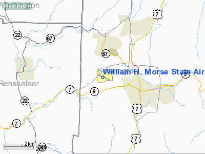
William H. Morse State Airport |
Coordinates: 42°53′28″N 073°14′46″W / 42.89111°N 73.24611°W / 42.89111; -73.24611
| William H. Morse State Airport |
| IATA: none – ICAO: KDDH – FAA LID: DDH |
| Summary |
| Airport type |
Public |
| Owner |
State of Vermont |
| Location |
Bennington, Vermont |
| Elevation AMSL |
827 ft / 252 m |
| Runways |
| Direction |
Length |
Surface |
| ft |
m |
| 13/31 |
3,704 |
1,129 |
Asphalt |
| Statistics (2005) |
| Aircraft operations |
27,290 |
| Based aircraft |
50 |
| Source: Federal Aviation Administration |
William H. Morse State Airport (ICAO: KDDH, FAA LID: DDH) is a state-owned public-use airport located three miles (5 km) west of the central business district of Bennington, a town in Bennington County, Vermont, United States. It is also referred to as "Southwest Vermont's Airport". It is the hub of cargo airline AirNow.
Although most U.S. airports use the same three-letter location identifier for the FAA and IATA, William H. Morse State Airport is assigned DDH by the FAA but has no designation from the IATA.
Facilities and aircraft
William H. Morse State Airport covers an area of 100 acres (40 ha) which contains one asphalt paved runway (13/31) measuring 3,704 x 75 ft (1,129 x 23 m).
For the 12-month period ending April 30, 2005, the airport had 27,290 aircraft operations, an average of 74 per day: 89% general aviation, 11% air taxi and <1% military. There are 50 aircraft based at this airport: 48% single engine, 36% multi-engine, 4% helicopters and 12% ultralights.
The above content comes from Wikipedia and is published under free licenses – click here to read more.
Location & QuickFacts
| FAA Information Effective: | 2008-09-25 |
| Airport Identifier: | DDH |
| Airport Status: | Operational |
| Longitude/Latitude: | 073-14-45.9000W/42-53-28.3000N
-73.246083/42.891194 (Estimated) |
| Elevation: | 827 ft / 252.07 m (Surveyed) |
| Land: | 100 acres |
| From nearest city: | 3 nautical miles W of Bennington, VT |
| Location: | Bennington County, VT |
| Magnetic Variation: | 14W (1980) |
Owner & Manager
| Ownership: | Publicly owned |
| Owner: | State Of Vermont |
| Address: | 133 State St
Montpelier, VT 05633 |
| Phone number: | 802-828-2833 |
| Manager: | Tim Maroney |
| Address: | 1563 Walloomsak Road
Bennington, VT 05201 |
| Phone number: | 802-753-5212 |
Airport Operations and Facilities
| Airport Use: | Open to public |
| Wind indicator: | Yes |
| Segmented Circle: | Yes |
| Control Tower: | No |
| Lighting Schedule: | DUSK-DAWN
ACTVT MIRL RY 13/31 & REIL RYS 13 & 31 & PAPI RYS 13 & 31 - CTAF. |
| Beacon Color: | Clear-Green (lighted land airport) |
| Landing fee charge: | No |
| Sectional chart: | New York |
| Region: | ANE - New England |
| Boundary ARTCC: | ZBW - Boston |
| Tie-in FSS: | BTV - Burlington |
| FSS on Airport: | No |
| FSS Toll Free: | 1-800-WX-BRIEF |
| NOTAMs Facility: | BTV (NOTAM-d service avaliable) |
| Federal Agreements: | NGY |
Airport Communications
| CTAF: | 122.800 |
| Unicom: | 122.800 |
Airport Services
| Fuel available: | 100LLA
100LL SELF-SVC AVBL 24 HRS. |
| Airframe Repair: | MAJOR |
| Power Plant Repair: | MAJOR |
| Bottled Oxygen: | NONE |
| Bulk Oxygen: | NONE |
Runway Information
Runway 13/31
| Dimension: | 3704 x 75 ft / 1129.0 x 22.9 m |
| Surface: | ASPH, Fair Condition |
| Weight Limit: | Single wheel: 12500 lbs. |
| Edge Lights: | Medium |
| |
Runway 13 |
Runway 31 |
| Longitude: | 073-15-07.7591W | 073-14-23.9887W |
| Latitude: | 42-53-37.0145N | 42-53-19.6245N |
| Elevation: | 794.00 ft | 827.00 ft |
| Alignment: | 118 | 127 |
| Traffic Pattern: | Left | Right |
| Markings: | Basic, Good Condition | Basic, Good Condition |
| Crossing Height: | 45.00 ft | 45.00 ft |
| VASI: | 4-light PAPI on left side | 4-light PAPI on right side |
| Visual Glide Angle: | 4.00° | 4.00° |
| Runway End Identifier: | Yes | Yes
RY 31 REIL OTS INDEFLY. |
| Obstruction: | 159 ft hill, 2781.0 ft from runway, 549 ft right of centerline, 16:1 slope to clear | 17 ft gnd, 208.0 ft from runway, 203 ft right of centerline
+20 FT GND 250 FT R OF CNTRLN. |
|
Radio Navigation Aids
| ID |
Type |
Name |
Ch |
Freq |
Var |
Dist |
| PSF | FAN MARKER | Abyss | | | 13W | 26.2 nm |
| GBR | FAN MARKER | Sheffield | | | 13W | 46.2 nm |
| R | FAN MARKER | Chitt | | | 14W | 46.4 nm |
| VWD | NDB | Mount Snow | | 224.00 | 15W | 17.0 nm |
| DXT | NDB | Dalton | | 370.00 | 15W | 25.5 nm |
| HEU | NDB | Hunter | | 356.00 | 14W | 30.4 nm |
| SXD | NDB | Springfield | | 265.00 | 15W | 36.8 nm |
| GBR | NDB | Great Barrington | | 395.00 | 14W | 43.1 nm |
| PFH | NDB | Philmont | | 272.00 | 13W | 43.8 nm |
| ORE | NDB | Orange | | 205.00 | 15W | 46.6 nm |
| CNH | NDB | Claremont | | 233.00 | 16W | 47.9 nm |
| JJH | NDB | Johnstown | | 523.00 | 14W | 48.2 nm |
| CAM | VOR/DME | Cambridge | 097X | 115.00 | 14W | 7.5 nm |
| CTR | VOR/DME | Chester | 098X | 115.10 | 13W | 38.4 nm |
| RUT | VOR/DME | Rutland | 47X | 111.00 | 15W | 40.3 nm |
| ALB | VORTAC | Albany | 100X | 115.30 | 13W | 26.0 nm |
| GFL | VORTAC | Glens Falls | 039X | 110.20 | 14W | 31.5 nm |
| EEN | VORTAC | Keene | 031X | 109.40 | 14W | 42.5 nm |
| BAF | VORTAC | Barnes | 077X | 113.00 | 14W | 49.7 nm |
| ALB | VOT | Albany County | | 108.20 | | 26.9 nm |
Remarks
- RY CONDS MAY NOT BE MONITORED OR REPORTED WHEN THE ARPT IS UNATNDD.
- NOISE ABATEMENT PROCEDURES IN EFFECT. AVOID OVER FLYING HOMES SE OF ARPT. NOISE SENSITIVE AREA APCH END RY 31. PREFERRED USE RY IS 13. IF PRACTICAL ACFT DEP RY 13 USE BEST CLIMB RATE & WHEN ABOVE 400 FT AGL TURN LEFT WITHIN 1 MILE OF DEP END OF RY 13.
- GEESE ON & INVOF ARPT.
- GCO AVBL ON FREQ 121.725 THRU BTV CD & FLT SVCS.
- RY 13 THLD HAZARDOUS BIRD ACTIVITY.
- EXISTED PRIOR TO 1959.
Images and information placed above are from
http://www.airport-data.com/airport/DDH/
We thank them for the data!
| General Info
|
| Country |
United States
|
| State |
VERMONT
|
| FAA ID |
DDH
|
| Latitude |
42-53-28.797N
|
| Longitude |
073-14-47.067W
|
| Elevation |
826 feet
|
| Near City |
BENNINGTON
|
We don't guarantee the information is fresh and accurate. The data may
be wrong or outdated.
For more up-to-date information please refer to other sources.
|
|


