 |
|
| Warren-Sugarbush Airport |
| IATA: none – ICAO: none – FAA LID: 0B7 |
| Summary |
| Airport type |
Public |
| Owner |
Granite Intersection Inc |
| Serves |
Warren, Vermont |
| Elevation AMSL |
1,470 ft / 448 m |
| Coordinates |
44°07′00.218″N 072°49′37.409″W / 44.11672722°N 72.82705806°W / 44.11672722; -72.82705806 |
| Runways |
| Direction |
Length |
Surface |
| ft |
m |
| 04/22 |
2,575 |
785 |
Asphalt |
| Statistics (2005) |
| Aircraft operations |
18,500 |
| Based aircraft |
70 |
| Source: Federal Aviation Administration |
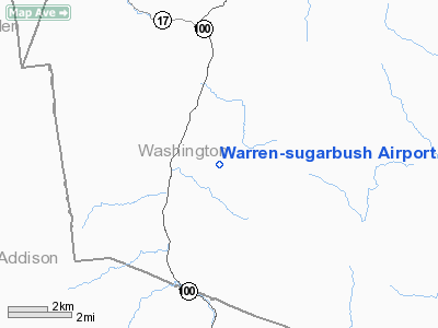
Warren-Sugarbush Airport is a public use airport in Washington County, Vermont, United States. It is owned by Granite Intersection Inc and is located two nautical miles (3.74 km) east of the central business district of the Town of Warren .
Although most U.S. airports use the same three-letter location identifier for the FAA and IATA, this airport is assigned 0B7 by the FAA but has no designation from the IATA.
Facilities and aircraft
Warren-Sugarbush Airport covers an area of 125 acres (50.6 ha) at an elevation of 1,470 feet (448 m) above mean sea level. It has one runway designated 04/22 with an asphalt surface measuring 4,575 by 30 feet (1,394 x 9.1 m).
For the 12-month period ending January 1, 2005, the airport had 18,500 aircraft operations, an average of 51 per day: 100% general aviation. At that time there were 70 aircraft based at this airport: 29% single-engine, and 71% gliders.
The above content comes from Wikipedia and is published under free licenses – click here to read more.
Location & QuickFacts
| FAA Information Effective: | 2008-09-25 |
| Airport Identifier: | 0B7 |
| Airport Status: | Operational |
| Longitude/Latitude: | 072-49-37.4090W/44-07-00.2180N
-72.827058/44.116727 (Estimated) |
| Elevation: | 1470 ft / 448.06 m (Estimated) |
| Land: | 125 acres |
| From nearest city: | 2 nautical miles E of Warren, VT |
| Location: | Washington County, VT |
| Magnetic Variation: | 16W (1985) |
Owner & Manager
| Ownership: | Privately owned |
| Owner: | Granite Intersection Inc |
| Address: | Box One
Waitsfield, VT 05673 |
| Phone number: | 802-496-2290 |
| Manager: | Rick Hanson |
| Address: | Po Box 123
Warren, VT 05674 |
| Phone number: | 802-496-2290 |
Airport Operations and Facilities
| Airport Use: | Open to public |
| Wind indicator: | Yes |
| Segmented Circle: | Yes
SEGMENTED CIRCLE NSTD. |
| Control Tower: | No |
| Landing fee charge: | No |
| Sectional chart: | Montreal |
| Region: | ANE - New England |
| Boundary ARTCC: | ZBW - Boston |
| Tie-in FSS: | BTV - Burlington |
| FSS on Airport: | No |
| FSS Toll Free: | 1-800-WX-BRIEF |
| NOTAMs Facility: | BTV (NOTAM-d service avaliable) |
| Federal Agreements: | N |
Airport Communications
| CTAF: | 123.000 |
| Unicom: | 123.000 |
Airport Services
| Fuel available: | 100LL
SELF SERVE |
Runway Information
Runway 04/22
| Dimension: | 2575 x 30 ft / 784.9 x 9.1 m |
| Surface: | ASPH, |
| Weight Limit: | Single wheel: 8500 lbs. |
| |
Runway 04 |
Runway 22 |
| Traffic Pattern: | Right | Left |
| Markings: | Numbers only, Good Condition | Numbers only, Good Condition |
| Runway End Identifier: | Yes | Yes |
| Centerline Lights: | No | No |
| Touchdown Lights: | No | No |
| Obstruction: | 30 ft tree, 332.0 ft from runway, 110 ft right of centerline, 4:1 slope to clear | 42 ft tree, 321.0 ft from runway, 125 ft left of centerline, 3:1 slope to clear |
|
Radio Navigation Aids
| ID |
Type |
Name |
Ch |
Freq |
Var |
Dist |
| MPV | FAN MARKER | Brook | | | | 14.3 nm |
| R | FAN MARKER | Chitt | | | 14W | 29.5 nm |
| VKN | NDB | Mount Mansfield | | 268.00 | 16W | 17.2 nm |
| DYO | NDB | Smuto | | 221.00 | 15W | 25.3 nm |
| JRV | NDB | Morrisville/stowe | | 375.00 | 16W | 29.6 nm |
| IVV | NDB | White River | | 379.00 | 16W | 36.9 nm |
| LAH | NDB | Hanover | | 276.00 | 15W | 37.6 nm |
| LLX | NDB | Lyndonville | | 353.00 | 16W | 41.5 nm |
| CNH | NDB | Claremont | | 233.00 | 16W | 49.1 nm |
| MPV | VOR/DME | Montpelier | 045X | 110.80 | 16W | 16.4 nm |
| RUT | VOR/DME | Rutland | 47X | 111.00 | 15W | 35.9 nm |
| LEB | VOR/DME | Lebanon | 084X | 113.70 | 15W | 37.3 nm |
| BTV | VORTAC | Burlington | 122X | 117.50 | 15W | 22.8 nm |
| PLB | VORTAC | Plattsburgh | 116X | 116.90 | 15W | 45.4 nm |
| BTV | VOT | Burlington Intl | | 109.00 | | 25.2 nm |
Remarks
- EXTENSIVE GLIDER ACTIVITY ON ARPT SFC TO 18000 FT DALGT HOURS.
- ARPT CLSD NOV-APR.
- NO LINE OF SIGHT BTN RY ENDS.
- TOUCH & GO LDGS NOT PERMITTED.
- OCCASIONAL AEROBATIC ACTIVITY; ARPT MAY BE CLSD DURG THIS ACTIVITY; CHECK NOTAMS.
- GRASS AREAS NOT AUTHORIZED FOR TAKEOFFS & LDGS WITHOUT FIRST CHECKING UNICOM FOR FIELD CONDS.
- SEE AIRSPACE CASE 97-ANE-41-NRA.
Images and information placed above are from
http://www.airport-data.com/airport/0B7/
We thank them for the data!
| General Info
|
| Country |
United States
|
| State |
VERMONT
|
| FAA ID |
0B7
|
| Latitude |
44-07-00.218N
|
| Longitude |
072-49-37.409W
|
| Elevation |
1470 feet
|
| Near City |
WARREN
|
We don't guarantee the information is fresh and accurate. The data may
be wrong or outdated.
For more up-to-date information please refer to other sources.
|
|


