 |
|
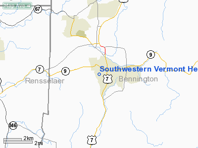
Southwestern Vermont Heliport |
Location & QuickFacts
| FAA Information Effective: | 2008-09-25 |
| Airport Identifier: | VT04 |
| Airport Status: | Operational |
| Longitude/Latitude: | 073-12-27.3000W/42-52-28.2900N
-73.207583/42.874525 (Estimated) |
| Elevation: | 800 ft / 243.84 m (Estimated) |
| Land: | 0 acres |
| From nearest city: | 0 nautical miles S of Bennington, VT |
| Location: | Bennington County, VT |
| Magnetic Variation: | 15W (1995) |
Owner & Manager
| Ownership: | Privately owned |
| Owner: | Sw Vermont Medical Center |
| Address: | 100 Hospital Drive
Bennington, VT 05201 |
| Phone number: | 802-442-6361 |
| Manager: | Mark Cappello |
| Address: | 100 Hospital Drive
Bennington, VT 05201 |
| Phone number: | 802-447-5121 |
Airport Operations and Facilities
| Airport Use: | Private |
| Segmented Circle: | No |
| Control Tower: | No |
| Region: | ANE - New England |
| Boundary ARTCC: | ZBW - Boston |
| Tie-in FSS: | BTV - Burlington |
| FSS Toll Free: | 1-800-WX-BRIEF |
Runway Information
Helipad H1
| Dimension: | 84 x 35 ft / 25.6 x 10.7 m |
| Surface: | ASPH, |
| |
Runway H1 |
Runway |
| Traffic Pattern: | Left | Left |
|
Radio Navigation Aids
| ID |
Type |
Name |
Ch |
Freq |
Var |
Dist |
| PSF | FAN MARKER | Abyss | | | 13W | 25.2 nm |
| GBR | FAN MARKER | Sheffield | | | 13W | 45.4 nm |
| R | FAN MARKER | Chitt | | | 14W | 46.9 nm |
| VWD | NDB | Mount Snow | | 224.00 | 15W | 15.5 nm |
| DXT | NDB | Dalton | | 370.00 | 15W | 24.3 nm |
| HEU | NDB | Hunter | | 356.00 | 14W | 32.0 nm |
| SXD | NDB | Springfield | | 265.00 | 15W | 36.2 nm |
| GBR | NDB | Great Barrington | | 395.00 | 14W | 42.5 nm |
| PFH | NDB | Philmont | | 272.00 | 13W | 43.8 nm |
| ORE | NDB | Orange | | 205.00 | 15W | 44.7 nm |
| CNH | NDB | Claremont | | 233.00 | 16W | 47.2 nm |
| CAM | VOR/DME | Cambridge | 097X | 115.00 | 14W | 9.4 nm |
| CTR | VOR/DME | Chester | 098X | 115.10 | 13W | 36.9 nm |
| RUT | VOR/DME | Rutland | 47X | 111.00 | 15W | 40.8 nm |
| ALB | VORTAC | Albany | 100X | 115.30 | 13W | 27.4 nm |
| GFL | VORTAC | Glens Falls | 039X | 110.20 | 14W | 33.2 nm |
| EEN | VORTAC | Keene | 031X | 109.40 | 14W | 40.7 nm |
| BAF | VORTAC | Barnes | 077X | 113.00 | 14W | 48.0 nm |
| ALB | VOT | Albany County | | 108.20 | | 28.2 nm |
Remarks
- PRVDD VFR; INGRESS/EGRESS TO THE SE ONLY; ALL USERS ARE NOTIFIED OF CONDITIONS ABOVE.
Images and information placed above are from
http://www.airport-data.com/airport/VT04/
We thank them for the data!
| General Info
|
| Country |
United States
|
| State |
VERMONT
|
| FAA ID |
VT04
|
| Latitude |
42-52-28.290N
|
| Longitude |
073-12-27.300W
|
| Elevation |
800 feet
|
| Near City |
BENNINGTON
|
We don't guarantee the information is fresh and accurate. The data may
be wrong or outdated.
For more up-to-date information please refer to other sources.
|
|


