 |
|
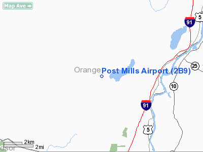
| Post Mills Airport |
| IATA: none – ICAO: none – FAA LID: 2B9 |
| Summary |
| Airport type |
Public |
| Owner |
Brian Boland |
| Serves |
Post Mills, Vermont |
| Elevation AMSL |
693 ft / 211 m |
| Coordinates |
43°53′03.246″N 072°15′13.332″W / 43.884235°N 72.25370333°W / 43.884235; -72.25370333 |
| Runways |
| Direction |
Length |
Surface |
| ft |
m |
| 04/22 |
2,900 |
884 |
Turf |
| 05/23 |
2,300 |
701 |
Turf |
| Statistics (2009) |
| Aircraft operations |
4,333 |
| Based aircraft |
33 |
| Source: Federal Aviation Administration |
Post Mills Airport is a public use airport in Orange County, Vermont, United States. It is owned by Brian Boland and is located within the central business district of the Village of Post Mills.
Although most U.S. airports use the same three-letter location identifier for the FAA and IATA, this airport is assigned 2B9 by the FAA but has no designation from the IATA
Facilities and aircraft
Post Mills Airport covers an area of 50 acres (20.2 ha) at an elevation of 693 feet (211 m) above mean sea level. It has two turf runways designated 04/22, with a surface measuring 2,900 by 80 feet (884 x 24 m) and 05/23, with a surface measuring 2,300 by 80 feet (701 x 24 m).
For the 12-month period ending June 2, 2009, the airport had 4,333 aircraft operations, an average of 12 per day: 100% general aviation with a few air taxi and ultralights. At that time there were 33 aircraft based at this airport: 73% single-engine, 18% gliders and 9% ultralights.
The above content comes from Wikipedia and is published under free licenses – click here to read more.
Location & QuickFacts
| FAA Information Effective: | 2008-09-25 |
| Airport Identifier: | 2B9 |
| Airport Status: | Operational |
| Longitude/Latitude: | 072-15-13.3320W/43-53-03.2460N
-72.253703/43.884235 (Estimated) |
| Elevation: | 693 ft / 211.23 m (Surveyed) |
| Land: | 50 acres |
| From nearest city: | 0 nautical miles E of Post Mills, VT |
| Location: | Orange County, VT |
| Magnetic Variation: | 16W (1985) |
Owner & Manager
| Ownership: | Privately owned |
| Owner: | Brian Boland |
| Address: | Po Box 51
Post Mills, VT 05058 |
| Phone number: | 802-333-9254 |
| Manager: | Brian Boland |
| Address: | Po Box 51
Post Mills, VT 05058 |
| Phone number: | 802-333-9254 |
Airport Operations and Facilities
| Airport Use: | Open to public |
| Wind indicator: | Yes |
| Segmented Circle: | No |
| Control Tower: | No |
| Landing fee charge: | No |
| Sectional chart: | New York |
| Region: | ANE - New England |
| Boundary ARTCC: | ZBW - Boston |
| Tie-in FSS: | BTV - Burlington |
| FSS on Airport: | No |
| FSS Toll Free: | 1-800-WX-BRIEF |
| NOTAMs Facility: | BTV (NOTAM-d service avaliable) |
| Federal Agreements: | N |
Airport Communications
| CTAF: | 122.800 |
| Unicom: | 122.800 |
Airport Services
| Airframe Repair: | MINOR |
| Power Plant Repair: | MINOR |
| Bottled Oxygen: | NONE |
| Bulk Oxygen: | NONE |
Runway Information
Runway 04/22
| Dimension: | 2900 x 80 ft / 883.9 x 24.4 m |
| Surface: | TURF, Good Condition |
| |
Runway 04 |
Runway 22 |
| Traffic Pattern: | Right | Left |
| Markings: | None, | None, |
| Runway End Identifier: | No | No |
| Touchdown Lights: | No | No |
| Obstruction: | 20 ft tree, 50 ft left of centerline | 15 ft road, 0.0 ft from runway |
|
Runway 05/23
| Dimension: | 2300 x 80 ft / 701.0 x 24.4 m |
| Surface: | TURF, Good Condition |
| |
Runway 05 |
Runway 23 |
| Traffic Pattern: | Right | Left |
| Markings: | None, | None, |
| Runway End Identifier: | No | No |
| Centerline Lights: | No | No |
| Touchdown Lights: | No | No |
| Obstruction: | 20 ft brush | 15 ft road, 0.0 ft from runway |
|
Radio Navigation Aids
| ID |
Type |
Name |
Ch |
Freq |
Var |
Dist |
| MPV | FAN MARKER | Brook | | | | 31.5 nm |
| R | FAN MARKER | Chitt | | | 14W | 34.6 nm |
| LCI | FAN MARKER | Laconia | | | | 40.1 nm |
| HIE | FAN MARKER | Witey | | | 17W | 41.5 nm |
| LAH | NDB | Hanover | | 276.00 | 15W | 11.4 nm |
| IVV | NDB | White River | | 379.00 | 16W | 21.5 nm |
| CNH | NDB | Claremont | | 233.00 | 16W | 31.4 nm |
| DYO | NDB | Smuto | | 221.00 | 15W | 32.3 nm |
| VKN | NDB | Mount Mansfield | | 268.00 | 16W | 35.7 nm |
| LC | NDB | Blnap | | 328.00 | 16W | 37.5 nm |
| GMA | NDB | Mahn | | 386.00 | 17W | 37.8 nm |
| LLX | NDB | Lyndonville | | 353.00 | 16W | 38.5 nm |
| SXD | NDB | Springfield | | 265.00 | 15W | 39.7 nm |
| JRV | NDB | Morrisville/stowe | | 375.00 | 16W | 44.1 nm |
| LEB | VOR/DME | Lebanon | 084X | 113.70 | 15W | 12.5 nm |
| MPV | VOR/DME | Montpelier | 045X | 110.80 | 16W | 14.8 nm |
| RUT | VOR/DME | Rutland | 47X | 111.00 | 15W | 37.1 nm |
| CON | VORTAC | Concord | 076X | 112.90 | 15W | 49.7 nm |
Remarks
- NO SNOW REMOVAL. ARPT OPEN TO SKI ACFT ONLY WHEN SNOW COVERED. CALL 802-333-9254 FOR INFO.
- ULTRALIGHTS; GLIDERS & HOT AIR BALLOONS ON & INVOF ARPT.
- TREES 400 FT FM END OF RYS 22 & 23.
- ARPT EXISTED PRIOR TO 1959.
Images and information placed above are from
http://www.airport-data.com/airport/2B9/
We thank them for the data!
| General Info
|
| Country |
United States
|
| State |
VERMONT
|
| FAA ID |
2B9
|
| Latitude |
43-53-03.246N
|
| Longitude |
072-15-13.332W
|
| Elevation |
693 feet
|
| Near City |
POST MILLS
|
We don't guarantee the information is fresh and accurate. The data may
be wrong or outdated.
For more up-to-date information please refer to other sources.
|
|


