 |
|
Coordinates: 44°53′20″N 072°13′45″W / 44.88889°N 72.22917°W / 44.88889; -72.22917
| Newport State Airport |
| IATA: EFK – ICAO: KEFK – FAA LID: EFK |
| Summary |
| Airport type |
Public |
| Owner |
State of Vermont |
| Serves |
Newport, Vermont |
| Elevation AMSL |
930 ft / 283 m |
| Runways |
| Direction |
Length |
Surface |
| ft |
m |
| 5/23 |
4,000 |
1,219 |
Asphalt |
| 18/36 |
4,000 |
1,219 |
Asphalt |
| Statistics (2008) |
| Aircraft operations |
8,784 |
| Based aircraft |
20 |
| Source: Federal Aviation Administration |
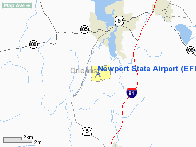
Newport State Airport (IATA: EFK, ICAO: KEFK, FAA LID: EFK) is a public airport located three miles (5 km) southwest of the central business district of Newport, a city in Orleans County, Vermont, United States. It is owned by the State of Vermont. Facilities and aircraft
Newport State Airport covers an area of 540 acres (219 ha) which contains two asphalt paved runways (5/23 and 18/36), each measuring 4,000 x 100 ft (1,219 x 30 m).
For the 12-month period ending August 18, 1997, the airport had 7,140 aircraft operations, an average of 19 per day: 97% general aviation and 3% military. There are 17 aircraft based at this airport: 88% single engine and 12% multi-engine.
Phish farewell concert
On August 14 - August 15, 2004 the airport served as the site of Coventry, the former final live concert appearance by the musical group Phish, attended by tens of thousands of fans.
The above content comes from Wikipedia and is published under free licenses – click here to read more.
Location & QuickFacts
| FAA Information Effective: | 2008-09-25 |
| Airport Identifier: | EFK |
| Airport Status: | Operational |
| Longitude/Latitude: | 072-13-44.9700W/44-53-19.6700N
-72.229158/44.888797 (Estimated) |
| Elevation: | 930 ft / 283.46 m (Surveyed) |
| Land: | 540 acres |
| From nearest city: | 3 nautical miles SW of Newport, VT |
| Location: | Orleans County, VT |
| Magnetic Variation: | 17W (1995) |
Owner & Manager
| Ownership: | Publicly owned |
| Owner: | State Of Vermont |
| Address: | 133 State St
Montpelier, VT 05602 |
| Phone number: | 802-828-1083 |
| Manager: | Dan Gauvin |
| Address: | Airport Road
Newport, VT 05855 |
| Phone number: | 802-334-5001 |
Airport Operations and Facilities
| Airport Use: | Open to public |
| Wind indicator: | Yes |
| Segmented Circle: | Yes |
| Control Tower: | No |
| Lighting Schedule: | DUSK-DAWN
ACTVT MIRL RY 18/36 AND PAPI RY 36 - CTAF. |
| Beacon Color: | Clear-Green (lighted land airport) |
| Landing fee charge: | No |
| Sectional chart: | Montreal |
| Region: | ANE - New England |
| Boundary ARTCC: | ZBW - Boston |
| Tie-in FSS: | BTV - Burlington |
| FSS on Airport: | No |
| FSS Toll Free: | 1-800-WX-BRIEF |
| NOTAMs Facility: | BTV (NOTAM-d service avaliable) |
| Federal Agreements: | NGY3 |
Airport Communications
| CTAF: | 122.800 |
| Unicom: | 122.800 |
Airport Services
| Fuel available: | 100LLA
24/7 SELF SERVE. |
| Airframe Repair: | MAJOR |
| Power Plant Repair: | MINOR |
| Bottled Oxygen: | NONE |
| Bulk Oxygen: | NONE |
Runway Information
Runway 05/23
| Dimension: | 4000 x 100 ft / 1219.2 x 30.5 m |
| Surface: | ASPH, Fair Condition |
| Weight Limit: | Single wheel: 30000 lbs.
Dual wheel: 44000 lbs. |
| |
Runway 05 |
Runway 23 |
| Longitude: | 072-14-05.5020W | 072-13-38.1370W |
| Latitude: | 44-53-04.9630N | 44-53-39.3160N |
| Elevation: | 922.00 ft | 926.00 ft |
| Alignment: | 30 | 127 |
| Traffic Pattern: | Left | Left |
| Markings: | Basic, Fair Condition | Basic, Fair Condition |
| Obstruction: | 45 ft trees, 349.0 ft from runway, 191 ft left of centerline, 3:1 slope to clear | 73 ft tree, 1254.0 ft from runway, 176 ft right of centerline, 14:1 slope to clear |
|
Runway 18/36
| Dimension: | 4000 x 100 ft / 1219.2 x 30.5 m |
| Surface: | ASPH, |
| Weight Limit: | Single wheel: 30000 lbs.
Dual wheel: 44000 lbs. |
| Edge Lights: | Medium |
| |
Runway 18 |
Runway 36 |
| Longitude: | 072-13-47.9080W | 072-13-28.4970W |
| Latitude: | 44-53-35.6460N | 44-52-58.6710N |
| Elevation: | 929.00 ft | 917.00 ft |
| Alignment: | 127 | 127 |
| Traffic Pattern: | Left | Left |
| Markings: | Non-precision instrument, Good Condition | Non-precision instrument, Good Condition |
| Crossing Height: | 0.00 ft | 69.00 ft |
| VASI: | | 2-light PAPI on left side |
| Visual Glide Angle: | 0.00° | 4.00° |
| Runway End Identifier: | | Yes |
| Obstruction: | 38 ft tree, 247.0 ft from runway, 386 ft right of centerline, 1:1 slope to clear | 73 ft trees, 986.0 ft from runway, 439 ft right of centerline, 11:1 slope to clear |
|
Radio Navigation Aids
| ID |
Type |
Name |
Ch |
Freq |
Var |
Dist |
| MPV | FAN MARKER | Brook | | | | 38.8 nm |
| HIE | FAN MARKER | Witey | | | 17W | 42.4 nm |
| EFK | NDB | Newport | | 242.00 | 17W | 4.4 nm |
| JRV | NDB | Morrisville/stowe | | 375.00 | 16W | 24.1 nm |
| LLX | NDB | Lyndonville | | 353.00 | 16W | 24.6 nm |
| VKN | NDB | Mount Mansfield | | 268.00 | 16W | 36.1 nm |
| GMA | NDB | Mahn | | 386.00 | 17W | 39.3 nm |
| SC | NDB | Sherbrooke | | 362.00 | 17W | 39.9 nm |
| HXK | NDB | Hornebrook | | 281.00 | 17W | 48.6 nm |
| BML | VOR/DME | Berlin | 041X | 110.40 | 17W | 47.1 nm |
| MPV | VOR/DME | Montpelier | 045X | 110.80 | 16W | 49.2 nm |
| YSC | VORTAC | Sherbrooke | 079X | 113.20 | 17W | 31.8 nm |
| BTV | VOT | Burlington Intl | | 109.00 | | 46.8 nm |
Remarks
- GULLS ON & INVOF ARPT.
- RWY 05/23 CLSD WINTER MONTHS.
- RY CONDS MAY NOT BE MONITORED OR REPORTED WHEN THE ARPT IS UNATNDD.
- ESTAB PRIOR 1959
Images and information placed above are from
http://www.airport-data.com/airport/EFK/
We thank them for the data!
| General Info
|
| Country |
United States
|
| State |
VERMONT
|
| FAA ID |
EFK
|
| Latitude |
44-53-19.670N
|
| Longitude |
072-13-44.970W
|
| Elevation |
930 feet
|
| Near City |
NEWPORT
|
We don't guarantee the information is fresh and accurate. The data may
be wrong or outdated.
For more up-to-date information please refer to other sources.
|
|


