 |
|
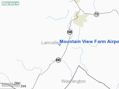
Mountain View Farm Airport |
Location & QuickFacts
| FAA Information Effective: | 2008-09-25 |
| Airport Identifier: | VT64 |
| Airport Status: | Operational |
| Longitude/Latitude: | 072-38-28.4200W/44-30-55.1900N
-72.641228/44.515331 (Estimated) |
| Elevation: | 1200 ft / 365.76 m (Estimated) |
| Land: | 0 acres |
| From nearest city: | 5 nautical miles S of Morristown, VT |
| Location: | Lamoille County, VT |
| Magnetic Variation: | 16W (1995) |
Owner & Manager
| Ownership: | Privately owned |
| Owner: | John Tonelli |
| Address: | 124 East 84th St
New York, NY 10028 |
| Phone number: | 212-504-6619 |
| Manager: | John Tonelli |
| Address: | 124 East 84th St
New York, NY 10028 |
| Phone number: | 212-504-6619 |
Airport Operations and Facilities
| Airport Use: | Private |
| Segmented Circle: | No |
| Control Tower: | No |
| Region: | ANE - New England |
| Boundary ARTCC: | ZBW - Boston |
| Tie-in FSS: | BTV - Burlington |
| FSS Toll Free: | 1-800-WX-BRIEF |
Runway Information
Runway 02/20
| Dimension: | 1500 x 60 ft / 457.2 x 18.3 m |
| Surface: | TURF, |
| |
Runway 02 |
Runway 20 |
| Traffic Pattern: | Left | Left |
|
Radio Navigation Aids
| ID |
Type |
Name |
Ch |
Freq |
Var |
Dist |
| MPV | FAN MARKER | Brook | | | | 11.7 nm |
| HIE | FAN MARKER | Witey | | | 17W | 47.1 nm |
| JRV | NDB | Morrisville/stowe | | 375.00 | 16W | 4.5 nm |
| VKN | NDB | Mount Mansfield | | 268.00 | 16W | 8.1 nm |
| LLX | NDB | Lyndonville | | 353.00 | 16W | 26.2 nm |
| EFK | NDB | Newport | | 242.00 | 17W | 32.9 nm |
| GMA | NDB | Mahn | | 386.00 | 17W | 42.0 nm |
| MPV | VOR/DME | Montpelier | 045X | 110.80 | 16W | 27.1 nm |
| BTV | VORTAC | Burlington | 122X | 117.50 | 15W | 24.3 nm |
| PLB | VORTAC | Plattsburgh | 116X | 116.90 | 15W | 39.1 nm |
| BTV | VOT | Burlington Intl | | 109.00 | | 22.0 nm |
Remarks
- OPNS DURING DAYLGT VFR ONLY.
- PRVDD NO CONFLICT WITH MORRISVILLE STOWE STATE ARPT; DAYLGT VFR OPNS; USERS ARE ADVISED OF THESE CONDTIONS.
Images and information placed above are from
http://www.airport-data.com/airport/VT64/
We thank them for the data!
| General Info
|
| Country |
United States
|
| State |
VERMONT
|
| FAA ID |
VT64
|
| Latitude |
44-30-55.190N
|
| Longitude |
072-38-28.420W
|
| Elevation |
1200 feet
|
| Near City |
MORRISTOWN
|
We don't guarantee the information is fresh and accurate. The data may
be wrong or outdated.
For more up-to-date information please refer to other sources.
|
|


