 |
|
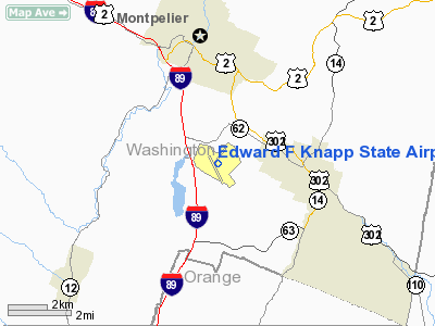
Edward F Knapp State Airport |
Coordinates: 44°12′13″N 072°33′44″W / 44.20361°N 72.56222°W / 44.20361; -72.56222
| Edward F. Knapp State Airport |
| IATA: MPV – ICAO: KMPV – FAA LID: MPV |
| Summary |
| Airport type |
Public |
| Owner |
State of Vermont |
| Serves |
Barre / Montpelier |
| Elevation AMSL |
1,165 ft / 355 m |
| Runways |
| Direction |
Length |
Surface |
| ft |
m |
| 17/35 |
5,002 |
1,525 |
Asphalt |
| 5/23 |
4,022 |
1,226 |
Asphalt |
| Statistics (1998) |
| Aircraft operations |
32,000 |
| Based aircraft |
57 |
| Source: Federal Aviation Administration |
Edward F. Knapp State Airport (IATA: MPV, ICAO: KMPV, FAA LID: MPV) is a general aviation airport located in Berlin, Vermont, United States; it is located three miles (5 km) west of the central business district of Barre. As well as serving Barre, it also serves the Montpelier region. It currently has no scheduled airline service, but the airport was formerly served by Air New England.
The airport began a major construction project in April 2010, constructing a new taxiway, as well repaving the runway and expanding the apron near the terminal area. The $6.2 million project was funded by the American Recovery and Reinvestment Act of 2009.
Facilities and aircraft
Edward F. Knapp State Airport covers an area of 259 acres (105 ha) which contains two asphalt paved runways: 17/35 measuring 5,002 x 100 ft (1,525 x 30 m) and 5/23 measuring 4,022 x 100 ft (1,226 x 30 m).
For the 12-month period ending July 17, 1998, the airport had 32,000 aircraft operations, an average of 87 per day: 94% general aviation, 3% air taxi and 3% military. There are 57 aircraft based at this airport: 96% single engine and 4% multi-engine.
The above content comes from Wikipedia and is published under free licenses – click here to read more.
Location & QuickFacts
| FAA Information Effective: | 2008-09-25 |
| Airport Identifier: | MPV |
| Airport Status: | Operational |
| Longitude/Latitude: | 072-33-44.3860W/44-12-12.6180N
-72.562329/44.203505 (Estimated) |
| Elevation: | 1165 ft / 355.09 m (Surveyed) |
| Land: | 259 acres |
| From nearest city: | 3 nautical miles W of Barre/montpelier, VT |
| Location: | Washington County, VT |
| Magnetic Variation: | 16W (1995) |
Owner & Manager
| Ownership: | Publicly owned |
| Owner: | Transportation Agcy Rapt Div |
| Address: | 133 State St
Montpelier, VT 05633 |
| Phone number: | 802-828-2833 |
| Manager: | John Roberti |
| Address: | Vt Flying Svc, 1979 Airport Road-berlin
Barre, VT 05641 |
| Phone number: | 802-223-2221 |
Airport Operations and Facilities
| Airport Use: | Open to public |
| Wind indicator: | Yes |
| Segmented Circle: | Yes |
| Control Tower: | No |
| Lighting Schedule: | DUSK-DAWN
ACTVT MIRL RY 17/35 & MALSR RY 17 - CTAF. |
| Beacon Color: | Clear-Green (lighted land airport) |
| Landing fee charge: | No |
| Sectional chart: | Montreal |
| Region: | ANE - New England |
| Boundary ARTCC: | ZBW - Boston |
| Tie-in FSS: | BTV - Burlington |
| FSS on Airport: | No |
| FSS Toll Free: | 1-800-WX-BRIEF |
| NOTAMs Facility: | MPV (NOTAM-d service avaliable) |
| Federal Agreements: | NGY3 |
Airport Communications
| CTAF: | 122.800 |
| Unicom: | 122.800
UNICOM BASE STN NOT MANNED CONT. |
Airport Services
| Fuel available: | 100LLA |
| Airframe Repair: | MAJOR |
| Power Plant Repair: | MAJOR |
| Bottled Oxygen: | NONE |
| Bulk Oxygen: | NONE |
Runway Information
Runway 05/23
| Dimension: | 4022 x 100 ft / 1225.9 x 30.5 m
150 FT TURN-AROUNDS AT BOTH END OF RY 17 & 35. |
| Surface: | ASPH, Good Condition |
| Weight Limit: | Single wheel: 30000 lbs.
Dual wheel: 46000 lbs. |
| |
Runway 05 |
Runway 23 |
| Longitude: | 072-33-55.1029W | 072-33-25.5411W |
| Latitude: | 44-12-08.9851N | 44-12-42.5230N |
| Elevation: | 1113.00 ft | 1085.00 ft |
| Alignment: | 32 | 127 |
| Traffic Pattern: | Left | Left |
| Markings: | Basic, Good Condition | Basic, Good Condition |
| Displaced threshold: | 516.00 ft | 0.00 ft |
| Runway End Identifier: | No | No |
| Centerline Lights: | No | No |
| Touchdown Lights: | No | No |
| Obstruction: | 74 ft tree, 991.0 ft from runway, 322 ft left of centerline, 11:1 slope to clear
APCH RATIO 24:1 TO DSPLCD THLD. | 20 ft trees, 525.0 ft from runway, 163 ft left of centerline, 16:1 slope to clear |
|
Runway 17/35
| Dimension: | 5002 x 100 ft / 1524.6 x 30.5 m
150 FT TURN-AROUNDS AT BOTH END OF RY 17 & 35. |
| Surface: | ASPH, Fair Condition |
| Weight Limit: | Single wheel: 31000 lbs.
Dual wheel: 70000 lbs. |
| Edge Lights: | Medium |
| |
Runway 17 |
Runway 35 |
| Longitude: | 072-34-04.0190W | 072-33-31.4575W |
| Latitude: | 44-12-23.8349N | 44-11-40.3611N |
| Elevation: | 1092.00 ft | 1165.00 ft |
| Alignment: | 127 | 127 |
| ILS Type: | ILS/DME
| |
| Traffic Pattern: | Left | Left |
| Markings: | Precision instrument, Fair Condition | Non-precision instrument, Fair Condition |
| Crossing Height: | 50.00 ft | 0.00 ft |
| Displaced threshold: | 0.00 ft | 487.00 ft |
| VASI: | 4-light PAPI on left side | |
| Visual Glide Angle: | 3.00° | 0.00° |
| Approach lights: | MALSR | |
| Runway End Identifier: | No | Yes |
| Centerline Lights: | No | No |
| Touchdown Lights: | No | No |
| Obstruction: | 12 ft tree, 343.0 ft from runway, 347 ft left of centerline, 11:1 slope to clear | 145 ft tree, 2200.0 ft from runway, 100 ft left of centerline, 14:1 slope to clear
APCH RATIO 22:1 TO DSPLCD THLD. |
|
Radio Navigation Aids
| ID |
Type |
Name |
Ch |
Freq |
Var |
Dist |
| MPV | FAN MARKER | Brook | | | | 8.1 nm |
| R | FAN MARKER | Chitt | | | 14W | 38.4 nm |
| HIE | FAN MARKER | Witey | | | 17W | 44.0 nm |
| VKN | NDB | Mount Mansfield | | 268.00 | 16W | 12.4 nm |
| JRV | NDB | Morrisville/stowe | | 375.00 | 16W | 22.6 nm |
| LLX | NDB | Lyndonville | | 353.00 | 16W | 29.2 nm |
| DYO | NDB | Smuto | | 221.00 | 15W | 34.4 nm |
| LAH | NDB | Hanover | | 276.00 | 15W | 34.4 nm |
| IVV | NDB | White River | | 379.00 | 16W | 38.9 nm |
| GMA | NDB | Mahn | | 386.00 | 17W | 38.9 nm |
| EFK | NDB | Newport | | 242.00 | 17W | 48.0 nm |
| MPV | VOR/DME | Montpelier | 045X | 110.80 | 16W | 8.6 nm |
| LEB | VOR/DME | Lebanon | 084X | 113.70 | 15W | 34.9 nm |
| RUT | VOR/DME | Rutland | 47X | 111.00 | 15W | 44.0 nm |
| BTV | VORTAC | Burlington | 122X | 117.50 | 15W | 29.1 nm |
| BTV | VOT | Burlington Intl | | 109.00 | | 29.8 nm |
Remarks
- NO SNOW REMOVAL ON RY 05/23; RY CLOSED WHEN SNOW COVERED.
- FLD COND RPRT MAY NOT BE AVBL AND/OR CURRENT AT NIGHT.
- RY CONDS MAY NOT BE MONITORED OR REPORTED WHEN THE ARPT IS UNATNDD.
- JET TRAFFIC DO NOT USE SOUTHERNMOST TWY STUB.
- EXISTED PRIOR TO 1959
Images and information placed above are from
http://www.airport-data.com/airport/MPV/
We thank them for the data!
| General Info
|
| Country |
United States
|
| State |
VERMONT
|
| FAA ID |
MPV
|
| Latitude |
44-12-12.618N
|
| Longitude |
072-33-44.386W
|
| Elevation |
1165 feet
|
| Near City |
BARRE/MONTPELIER
|
We don't guarantee the information is fresh and accurate. The data may
be wrong or outdated.
For more up-to-date information please refer to other sources.
|
|


