 |
|
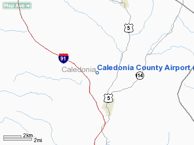
| Caledonia County Airport |
| IATA: LLX – ICAO: KCDA – FAA LID: CDA |
| Summary |
| Airport type |
Public |
| Owner |
State of Vermont |
| Serves |
Caledonia County |
| Location |
Lyndonville, Vermont |
| Elevation AMSL |
1,188 ft / 362 m |
| Coordinates |
44°34′09″N 072°01′05″W / 44.56917°N 72.01806°W / 44.56917; -72.01806 |
| Runways |
| Direction |
Length |
Surface |
| ft |
m |
| 2/20 |
3,300 |
1,006 |
Asphalt |
| Statistics (2007) |
| Aircraft operations |
4,690 |
| Based aircraft |
18 |
| Source: Federal Aviation Administration |
Caledonia County Airport (IATA: LLX, ICAO: KCDA, FAA LID: CDA, formerly 6B8) is a state-owned public-use airport located three nautical miles (6 km) north of the central business district of Lyndonville, a village in Caledonia County, Vermont, United States. It is also known as Caledonia County State Airport
Although most U.S. airports use the same three-letter location identifier for the FAA and IATA, this airport is assigned CDA by the FAA and LLX by the IATA (which assigned CDA to Cooinda, Northern Territory, Australia).
Facilities and aircraft
Caledonia County Airport covers an area of 78 acres (32 ha) at an elevation of 1,188 feet (362 m) above mean sea level. It has one asphalt paved runway designated 2/20 which measures 3,300 by 60 feet (1,006 x 18 m).
For the 12-month period ending December 12, 2007, the airport had 4,690 aircraft operations, an average of 12 per day: 97% general aviation, 2% air taxi and 1% military. At that time there were 18 aircraft based at this airport, all single-engine.
The above content comes from Wikipedia and is published under free licenses – click here to read more.
Location & QuickFacts
| FAA Information Effective: | 2008-09-25 |
| Airport Identifier: | CDA |
| Airport Status: | Operational |
| Longitude/Latitude: | 072-01-04.7240W/44-34-08.8110N
-72.017979/44.569114 (Estimated) |
| Elevation: | 1188 ft / 362.10 m (Surveyed) |
| Land: | 78 acres |
| From nearest city: | 3 nautical miles N of Lyndonville, VT |
| Location: | Caledonia County, VT |
| Magnetic Variation: | 16W (1995) |
Owner & Manager
| Ownership: | Publicly owned |
| Owner: | State Of Vermont |
| Address: | 133 State St
Montpelier, VT 05602 |
| Phone number: | 802-828-2833 |
| Manager: | Thomas Winans |
| Address: | 2107 Pudding Hill Road
Lyndonville, VT 05851-8985 |
| Phone number: | 802-626-3353
HOME 802-626-3604. |
Airport Operations and Facilities
| Airport Use: | Open to public |
| Wind indicator: | Yes |
| Segmented Circle: | Yes |
| Control Tower: | No |
| Lighting Schedule: | RDO-CTL
ACTVT REIL RY 02 & NSTD LIRL RY 02/20 - CTAF. |
| Landing fee charge: | No |
| Sectional chart: | Montreal |
| Region: | ANE - New England |
| Traffic Pattern Alt: | 1012 ft |
| Boundary ARTCC: | ZBW - Boston |
| Tie-in FSS: | BTV - Burlington |
| FSS on Airport: | No |
| FSS Toll Free: | 1-800-WX-BRIEF |
| NOTAMs Facility: | BTV (NOTAM-d service avaliable) |
| Federal Agreements: | NGY |
Airport Communications
| CTAF: | 122.800 |
| Unicom: | 122.800 |
Airport Services
| Fuel available: | 100LL |
| Bottled Oxygen: | NONE |
| Bulk Oxygen: | NONE |
Runway Information
Runway 02/20
| Dimension: | 3300 x 60 ft / 1005.8 x 18.3 m |
| Surface: | ASPH, Fair Condition |
| Weight Limit: | Single wheel: 12500 lbs. |
| Edge Lights: | Non-standard lighting system
HAS NSTD LIRL DUE TO NO AMBER/CLEAR GLOBES. |
| |
Runway 02 |
Runway 20 |
| Longitude: | 072-01-08.0640W | 072-01-01.3670W |
| Latitude: | 44-33-52.6910N | 44-34-24.9350N |
| Elevation: | 1178.00 ft | 1188.00 ft |
| Alignment: | 8 | 127 |
| Traffic Pattern: | Left | Left |
| Markings: | Non-precision instrument, Good Condition | Non-precision instrument, Good Condition |
| Runway End Identifier: | Yes | |
| Obstruction: | 45 ft trees, 207.0 ft from runway, 317 ft right of centerline | 112 ft trees, 1766.0 ft from runway, 362 ft right of centerline, 13:1 slope to clear |
|
Radio Navigation Aids
| ID |
Type |
Name |
Ch |
Freq |
Var |
Dist |
| HIE | FAN MARKER | Witey | | | 17W | 22.9 nm |
| MPV | FAN MARKER | Brook | | | | 31.2 nm |
| LLX | NDB | Lyndonville | | 353.00 | 16W | 3.9 nm |
| GMA | NDB | Mahn | | 386.00 | 17W | 18.9 nm |
| EFK | NDB | Newport | | 242.00 | 17W | 24.0 nm |
| JRV | NDB | Morrisville/stowe | | 375.00 | 16W | 24.4 nm |
| VKN | NDB | Mount Mansfield | | 268.00 | 16W | 31.0 nm |
| HXK | NDB | Hornebrook | | 281.00 | 17W | 35.9 nm |
| MPV | VOR/DME | Montpelier | 045X | 110.80 | 16W | 34.5 nm |
| BML | VOR/DME | Berlin | 041X | 110.40 | 17W | 35.8 nm |
| YSC | VORTAC | Sherbrooke | 079X | 113.20 | 17W | 46.0 nm |
| BTV | VOT | Burlington Intl | | 109.00 | | 48.9 nm |
Remarks
- MECHANIC ON CALL PPR - CALL 802-626-3353.
- RY CONDS MAY NOT BE MONITORED OR REPORTED WHEN ARPT IS UNATNDD.
- GCO AVBL ON FREQ 121.725 THRU BTV CD & FLT SVCS.
Images and information placed above are from
http://www.airport-data.com/airport/CDA/
We thank them for the data!
We don't guarantee the information is fresh and accurate. The data may
be wrong or outdated.
For more up-to-date information please refer to other sources.
|
|


